by Abigail Auld
Winnipeg, Manitoba
|
The histories of Winnipeg and the Hudson’s Bay Company (HBC) are closely bound. Upper Fort Garry, one of the HBC’s earliest posts, contributed largely to the city’s early growth. Today, Winnipeg plays a significant role as geographic home of the Hudson’s Bay Company Archives at the Archives of Manitoba. This longstanding relationship is evident in the wealth of Winnipeg-related HBCA holdings including maps, architectural drawings, photographs and business records. Together, this material draws attention to the profound influence the HBC has had on Winnipeg’s urban development. Early maps delineate HBC-owned property. Architectural drawings present numerous built and unbuilt HBC buildings. Newspaper clippings and correspondence concerning municipal development document HBC officials’ involvement in local civic affairs. The following records drawn from the HBCA demonstrate both the breadth of material available and pervasiveness of the HBC’s impact on Winnipeg’s built environment.
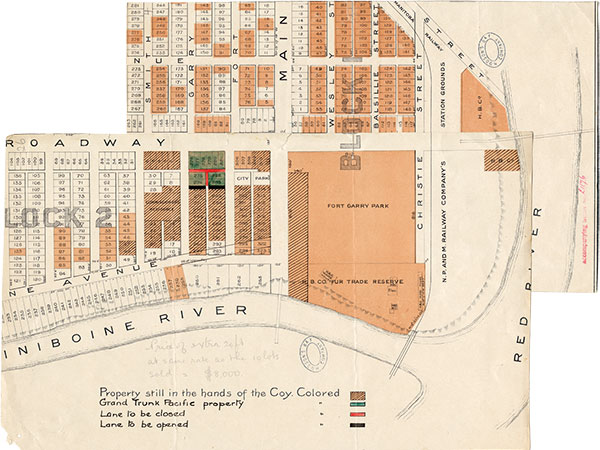
These portions of a larger map show Block One of the HBC Reserve, which was divided into four blocks. Block Two (between Assiniboine, Broadway, Main, and Kennedy) was developed as an upper-class residential neighborhood, whereas Blocks Three and Four (between Broadway, Notre Dame, Main, and Colony Creek) became mixed business-residential areas. Block One, which was plagued by flooding and difficult to develop, became a shantytown in the 1870s. [1]
Source: HBCA-A12-L-140-2-4-fos.04 &26.
The HBC transferred control of Rupert’s Land to the British Crown with the 1869 Deed of Surrender after two centuries of proprietorship. As part of this agreement the HBC received monetary compensation, a percentage of township lots across the western fertile belt, mineral rights and land holdings surrounding each HBC post. This amounted to 450 acres around Upper Fort Garry that was known as the HBC Reserve. The Reserve occupied much of the land within Winnipeg when the city was incorporated in 1873. Along with other large landowners (though no holdings compared to those of the HBC), the company resisted incorporation. In 1874 the HBC paid $595,312 in taxes, contributing significantly to Winnipeg’s infrastructure improvements, which were almost non-existent at the time. [2]
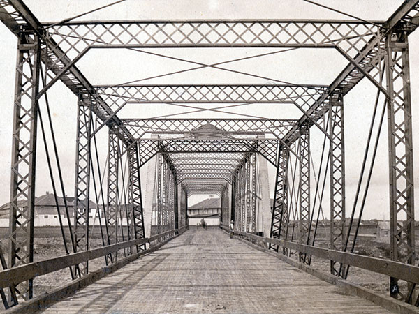
The Red River and Assiniboine Bridge Company, a subsidiary of the Hudson’s Bay Company, built the first two traffic bridges in Winnipeg. The Main Street Bridge, built in 1881, was operated by the company for only a year before being purchased by the City of Winnipeg. On 15 April 1882, the company opened a second bridge that extended Broadway across the Red River. The company operated the Broadway Bridge until 1909 when it was sold to the City of St. Boniface for $59,000. The Broadway Bridge continued in operation until 1917 and was replaced by the Provencher Bridge in 1918. [3]
Soon after the Manitoba Provincial Legislature was completed in 1920, planning began for a grand boulevard approach to building. The City of Winnipeg orchestrated a series of exchanges between landowners that included private citizens, the Province of Manitoba and the Hudson’s Bay Company. Construction on Memorial Boulevard began in 1925, with the HBC covering the cost of local improvements on both sides of the street along its frontage.
The Main Street Bridge, built by the HBC in 1881, crossed the Assiniboine River south of Upper Fort Garry.
Source: Hudson’s Bay Company Archives, 1987-363-W-200-17a.
While the HBC’s commercial presence is still visible at Portage and Memorial, its original retail location in Winnipeg remains somewhat inconspicuous. The Company’s first department store in the city opened in 1881 at the corner of Main Street and York Avenue. While the warehouse-like structure no longer exists, the store’s powerhouse still stands in the lane south of York Avenue between Main and Fort Street. The powerhouse was built by local architect John Woodman in 1906 and supplied energy to various surrounding HBC buildings including Hudson’s Bay House, built in 1910 (now Gibraltar House), and executive offices at Main and Broadway (just east of the Manitoba Club) and at 208 Main Street. [4]
In 1928, Barott and Blackader Architects, the firm that built Winnipeg’s 1926 HBC store, prepared preliminary plans for a complex of apartment blocks. The project site spanned Assiniboine Avenue, from Main Street across the old Upper Fort Garry site and behind the Fort Garry Hotel to the west side of Garry Street. Having owned this land since 1869, the HBC was eager to find a developer. These plans were prepared and mounted in the HBC Land Offices in an attempt to entice investors with the land’s development potential. The proposal consisted of a sketch perspective drawing, a general site plan showing the layout of eleven apartment blocks amongst landscaped gardens and tennis courts, and detailed floor plans for spacious three- to five-room apartment suites. While the blocks were never built, their grandeur is in keeping with the type of residential development the HBC helped attract to the surrounding neighbourhood.
While these records represent just a small sample of the HBC’s presence in Winnipeg, many more can be discovered in the HBCA’s holdings. These glimpses of the past reinvigorate an ordinary walk through Winnipeg’s city centre, revealing aspects of the HBC’s influence in the grid block pattern, familiar HBC street names and remaining Company buildings tucked away on side streets and back lanes.
Completed as part of a larger project entitled WPGxHBC, this research was conducted during a practicum with Debra Moore at the HBCA, Archives of Manitoba. The project also included a website (www.wpgxhbc.com), display windows at the HBC downtown store, a Jane’s Walk tour, postcards, buttons and a self-guided walking tour map. The practicum was part of the University of Winnipeg’s MA in Cultural Studies, Curatorial Practices Program.
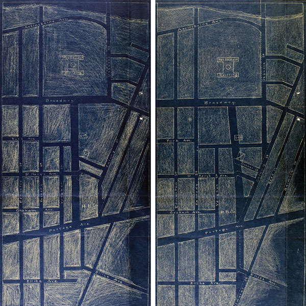
These sketched blueprints show two variations of the Memorial Boulevard approach. The left plan shows a straight mall with the proposed HBC property at the southwest corner of Portage and Memorial. The right plan is an example of the crooked mall with Osborne extending into Colony Street.
Source: Hudson’s Bay Company Archives, RG2-7-411-sheets-4a&b.
1. For further information on Block One, also known as the Hudson’s Bay Flats, see Randy R. Rostecki, “From Backwater to Park: The Forks in Relation to Downtown Winnipeg,” The Forks and the Battle of Seven Oaks in Manitoba History. Robert Coutts and Richard Stuart (eds.). Manitoba Historical Society, 1994.
2. Hudson’s Bay Company Archives, A-72-3 Secretary’s loose papers on land matters, 1862-1919.
3. Hudson’s Bay Company Archives, A-12-FT-276-1 Red River and Assiniboine Bridge Co., 1891-1909.
4. For HBC executive office see Archives of Manitoba, N9724-4; for 208 Main Street (the late Adanac Club) see Hudson’s Bay Company Archives, G-1-480, Hudson’s Bay Property Main Street Winnipeg Late Adanac Club, 1920.
Page revised: 4 February 2018