Search | Image Archive | Reference | Communities | POV | Lesson Plans | Credits
 Neepawa has always enjoyed the prosperity and affluence suggested by its name, which is derived from the Cree for "plenty." The Neepawa district, defined by the White Mud River valley is known to have been a site of human habitation for twelve thousand years. It was a popular wintering ground for the semi-nomadic Cree, Assiniboine and later Ojibwa who gathered in southwestern Manitoba for the annual buffalo hunt.
Prior to 1880 permanent settlement in the area was only sporadic, but, by the late 1870s, settlers began to consider the settlement possibilities of the Neepawa area. They were attracted in part by the availability of an east-west transportation links: the region was cut by the Fort Ellice Trail (the Saskatchewan Trail), a cart track that connected Red River with the Northwest Territories (Saskatchewan and Alberta). It was the Fort Ellice Trail that was the artery of the Métis Buffalo Hunt, and was used every year by the hunters as they journeyed from Fort Garry.
The first permanent settlers, a group of about thirty Ontarians, came to Neepawa in 1877. With the prospect of a railway line through the area, a number of speculators bough land and established businesses in anticipation of the market that would emerge if the line were constructed. After several disappointments, such a line was built in 1883 by the Manitoba and Northwest Railway, and Neepawa was connected to the Canadian Pacific main line at Portage La Prairie.
With the railway in place, adequate Neepawa was positioned to become a regional centre of commerce and trade, and it soon flourished in this capacity. Many of those who elected to farm in the Neepawa area arrived from Great Britain and Ontario. They were, as a whole, a class of wealthy farmers, cultivating large tracts of land by the standards of the day, and able to support a substantial commercial community.
Neepawa reflected the prosperity of the area in which it was situated. Although, as in any prairie centre, economic life was dominated by the wheat trade, Neepawa became an important centre for light manufacturing and food processing. Its role as a commercial centre was reinforced by its role as a seat of government. Manitoba's boundaries were extended to include the Neepawa area in 1881, and in 1884 the town was named as the administrative centre for the county of Beautiful Plains, a legal entity comprising four townships.
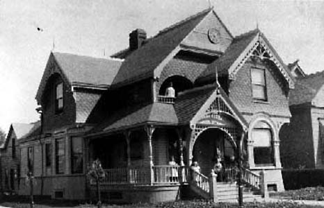
By 1900, the affluence of the community was evident. It was one of the few towns that was able to offer e telephone exchange, electric street lighting, piped drinking water, underground sewers, and even paved sidewalks. In 1904 a hospital was established, and there were two weekly newspapers. Neepawa was a model of British Canadian industry and prosperity, and this was reflected in the cultural life and identity of the community.
Page revised: 29 August 2009