
Introduction | The Assiniboine | The Souris | The Little Saskatchewan | The Boundary Trail | Here & There
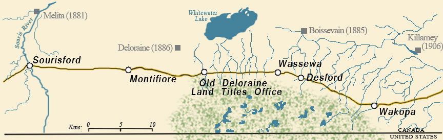
The Boundary Trail
The Oldest Highway in the West
The Boundary Commission trail was the route taken by the Boundary Commission in 1873 & 74 as they surveyed the Canada – US Border. They bridged creeks, established crossings, and cleared bush as necessary; but the general route they followed spans centuries, crosses cultural lines, and involves a multitude of goals and purposes.
Although one short period of its life at the dawn of European settlement gave the trail its name, it was well travelled long before that time.
Parts of it began as a First Nations travel and trading route, which the fur traders of the 18th Century naturally used when they began penetrating the interior of Rupert's Land as the region was then called. Not too long afterwards, the Red River carts of the Métis wore grooves into the prairie sod of the trail in their pursuit of the bison as the large animals retreated ever westward.
Many of the pioneers of European origin who came to take up homesteads in the southwestern corner of Manitoba in the 1880’s came from Ontario. One popular route was via boat to Duluth on Lake Superior, then by rail to a point on the Red River directly south of Winnipeg, where they might have a choice between a riverboat or a train to Emerson on the Manitoba - Dakota Territory border. Before the CPR began regular service west from Winnipeg in late 1881, most made their way westward along the Boundary Commission Trail, often in wagons drawn by oxen or horses, with whatever belongings and supplies they owned. It was a long, slow, journey, but the trail first blazed by the Boundary Commission in 1873 was well travelled, and several “Stopping Houses”, pioneer versions of the roadside motel, had been established in farm houses along the trail. If the weather cooperated, and the wagon didn’t lose a wheel or break an axle, it might well have been almost an enjoyable trip.
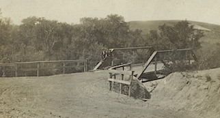
The Boundary Commission Trail in western Manitoba.
(Vantage Points Collection – TMSPHA)
River crossing could be tricky, depending on the time of year and the water levels. Fortunately, the Boundary Commission, following the lead of Aboriginal hunters and Metis traders, selected advantageous locations for crossing streams.
As technology marched on, new routes were drawn, first for trains, then for cars, and while the Boundary Trail was still useful for local travel for a time, the increased use of cars meant that even local and regional transportation shifted onto to those conveniently provided road allowances that bordered each section of land.
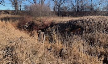
Evidence of the old trail faded except in a few places where the ruts were deeply etched into a hillside or valley wall. In Southwest Manitoba the streams that had to be crossed by the pioneers were not raging rivers, but in the springtime some of them could present a challenge
Using that evidence and the memories saved in written form by local histories, we will highlight a few of the more obvious examples of a pioneer crossing.
A Memory...
We set out across the frozen prairie on the Boundary Commission Trail to walk 125 miles west into the wilderness to find a homestead. Mother carried the baby in her arms. Uncle George managed to walk. I carried a big old gun which had been used in the Civil War. Father carried a big stick and pushed hard on the wagon box, saying "You'd been a good many miles behind if I hadn't kept shoving on the tailboard''.
Robert Blackwell
1. Clearwater - Former Bridge Site: N49.13306, W99.03069
2. Badger Creek. - Bridge Site and former ford: N49.10368 W99.32316
3. Wakopa - Former ford and bridge site: 49.06359. W 99.86393
For more info (pdf) ...