|


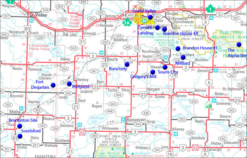
15: One Last
Look – Some Travel Tips &
Regional Explorations
A (Sort Of) Guided Tour
For
others that feel that way, let’s take a last look – here is a guide
to seeing the sites.
One
way to see these sites is what I call the “In the
neighbourhood” approach. Look at the following map of the region, and
when the opportunity presents itself, take advantage of being nearby.
My
interest in the
stories told here began with and interest in the place – the geography
– the river and the land. I like to walk the territory, see where
things happened, and get a sense of place.
Here’s an overview...
My interest in the
stories told here began with and interest in the place – the geography
– the river and the land. I like to walk the territory, see where
things happened, and get a sense of place.
For others that feel that way, let’s take a last look – here is a guide
to seeing the sites.
One way to see these sites is what I call the “In the
neighbourhood” approach. Look at the following map of the region, and
when the opportunity presents itself, take advantage of being nearby.
Here’s an overview...
I have also grouped the sites into five individual day trips. Two road
trips and three trips to individual sites that require setting aside
time for a hike. Of course you could just visit the vicinity of theses
sites, and on the other hand each of the “Road” trips could be expanded
and enhanced by doing some hiking and exploring.
Trip 1 Brandon South &
East
Grand Valley: N49.85716, W99.89459
Brandon Rapids: N 9.812972, W99.805562 & Currie’s Landing:
N49.80462, W 99.79451
Brandon House #4: Trail Head: N49.783376, W99.724065 /
Cairn: N49.77759, W99.74593
Brandon House #1: Trail Head: N49.680033, W 99.620794
/ Site: N49.675260, W99.627355
Souris Mouth Trail: N 49.679802 W99.573187 /
Overlook: N49.666374, W49.566354
Millford Village: N49.621565, W99.537819 /
Cemetery N49.620665, W99.563881
Souris City Overlook: N49.579850, W99.734358 /
Village Site: N49.569946, W99.726734
Trip 2 Brandon -
South & West
Bunclody: N49.53466, W100.05686
Melgund: N49.42877, W100.57887
Brockinton Site: N49.20112, W101.03352
Coulter Park / Sourisford: N49.13575 , W101.00811
The Sourisford Linear Mounds: N49.11686, W101.01711
Trip 3 – Hiking
Explorations
Gregory Mill: Trail Head: N49.514528 W99.839442
/ Mill Site: N49.524210, W99.828810
Fort Desjarlais: Start of Trail: N49.421560, W100.726036
/ Site: N49.436742, W 100.709969
The Alpha: N49.697601, W99.041878
Trip
One: Brandon and South East
Grand
Valley
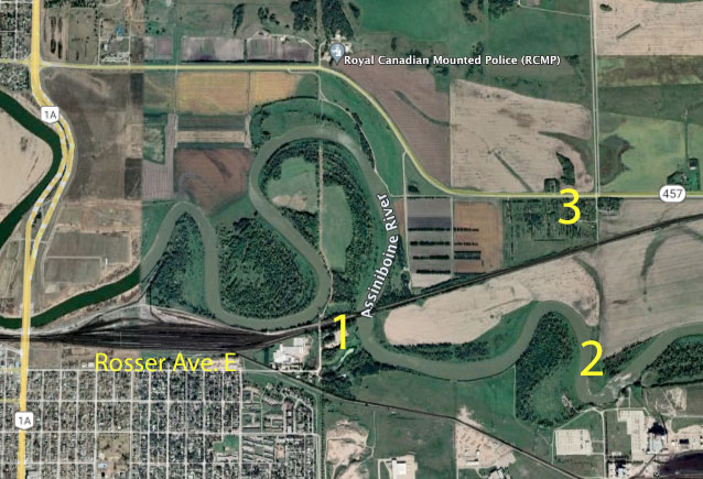
Before setting out from Brandon, to your first stop – the Grand Valley
Site, you might find it interesting to see just how close Grand Valley
really was to the spot General Rosser and his staff selected to cross
the Assiniboine. Drive eastward on Rosser Avenue as far as you
can go and you will find Old Crow’s General Store (1) and Park. A bit
of a stroll through the grounds will take you to the CRP bridge,
updated for sure, but on the very spot selected in 1881.
The village of Grand Valley (2) was just over a km to the east. The
cairn commemorating the site is along the road (3). N49.85716, W99.89459
Had the price been right, General Rosser could easily have located the
town on the east side of the Bridge, but it’s a good thing he
didn’t. The entire area between numbers 1, 2 and 3 was covered in
water soon after the decision was made, just as it was in 2011.
As you leave Brandon via 1St. St. N, turn west at the Shilo turnoff
(Road 457). In about three kilometres you come to what used to be a
tree nursery on the south side of the road. If you look closely you
will see the Grand Valley Cairn.
An abandoned roadway leads southwards towards a field to the
Assiniboine and the site of the former Grand Valley village and ferry
crossing.
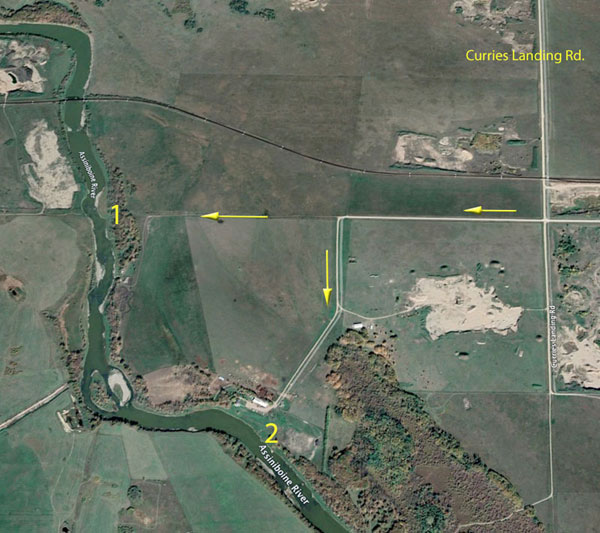
Currie’s Landing /
Brandon Rapids
From the Grand Valley Cairn proceed east for about eight km and turn
south on to Currie’s Landing Road. You cross railway tracks in
just over four kilometres and turn west at the next intersection. Less
than a kilometre ahead the road turns south towards the Currie’s
Landing site. If you proceed as far as you can and continue on foot,
you will get a look at the beginning of the Brandon Rapids. (1)
N49.812972, W 99.805562
If you want an alternate look at the rapids, they can be accessed from
the other side of the river on Road 55N.
If you continue south the road takes you into a private yard at the
former site of Currie’s Landing. (2) N49.80462, W99.79451
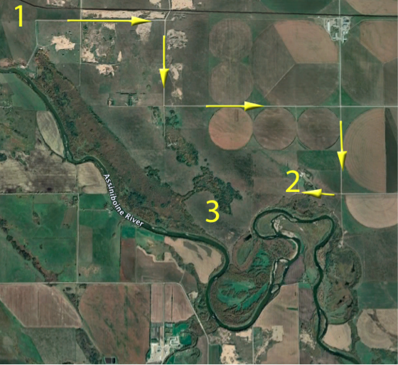
Brandon House #4
From the Currie’s Landing site, backtrack to the first road heading
east. (1) Go 1.5 km East, 1.5 km South, 3 km East , 1.5 km south
and 1 km west to the Waggle Springs Natural Area (2)
N49.783376 W99.724065. Take a walk on a trail overlooking
the Assiniboine in what is known as the Glen Souris area. If you
proceed east you will see the Brandon House #4 Cairn in an open area.
(3) N49.77759, W99.74593
This spot is certainly on of the places where one could spend an hour
or two hiking. The site is on a pasture on private land under a
conservation agreement. Access with a vehicle seems to be permitted
with the understanding that gates will be closed and the land respected.
Brandon House #1
From the Waggle Springs Natural Area you drive eastward to Highway
#340. Drive south to Road 47 N. Go 1.5 km east and I.5 km south.
The road then turns east, but if you look closely you will fine a
Wildlife Management Area sign and an overgrown trail. (1)
N49.783376, W99.724065
That trail will take you to the site of the first Brandon House which
was established in 1793. N49.675260. W99.627355
When you arrive at a fairly large clearing near the river, you will
find a few depressions. That’s all there is to see. The trail can be a
bit tricky in wet conditions. The best bet is to visit in mid summer or
fall.
The view from the north. The fort was in the clearing, and there were
several competing posts across the river at various times between 1793
and the early 1800’s.
It is also accessible from the Assiniboine River, on the north side,
just a short distance downstream from the bridge over Highway 340.
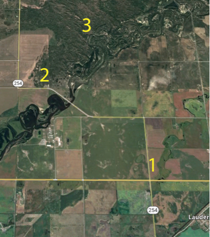
Souris Mouth
The Forts in the region were known collectively as the Souris Mouth
Posts, but the they were actually a few kilometres upstream from the
mouth of where the Souris River enters the Assiniboine. That location
was home to the first Land Titles Office in western Manitoba, and
later, a store, post office and school, but it never did even aspire to
being a village.
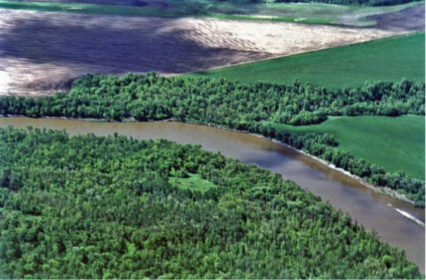
It is however a beautiful spot, and while you are in the neighbourhood,
it is certainly worth a look.
From the Corner at the Brandon House trail proceed east for 3 km., and
look for a “Wildlife Management Area” sign and a trail through the
woods heading south. (#2 on the earlier Google Earth images -
N49.679802 W99.573187)That will take you to an overlook
with a view of the mouth of the Souris River. (3) N.49.666374,
W49.566354
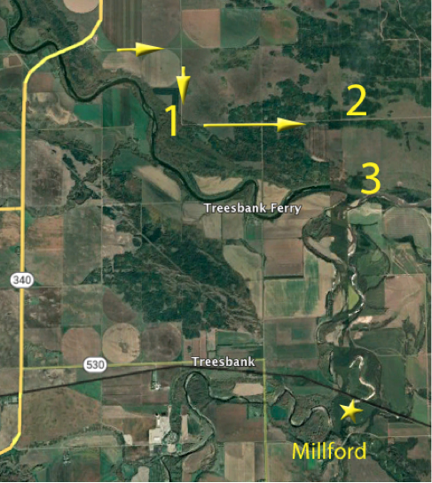
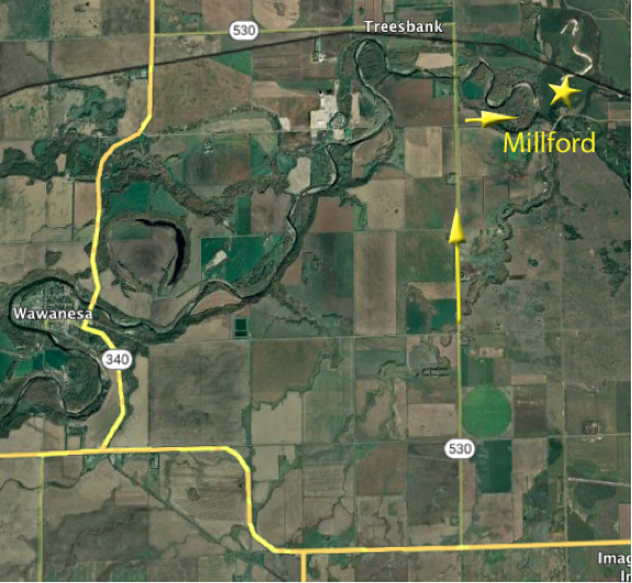
Millford
The former village of Millford is not far from Souris Mouth, but it is
quite a drive since they took out the Treesbank Ferry. And it now
requires even more back tracking since the Treesbank Bridge was washed
away in 2011.
Basically go back to Hwy 340, south through Wawanesa to Highway #2, the
north on Road 530. If you keep going you will come to the former site
of the Treesbank Bridge. That makes a nice side trip, but to get to
Millford turn east on Road 42N. The village was in the valley a little
over a kilometre ahead.
Millford Village Site – N49.621565 S99.537819
Millford Cemetery
As you continue east through the valley and up the hill you will find
the Millford Cairn and a very attractive Cemetery
(N49.620665, W99.563881). Take a wander through – you
should be able to find the gravesite of Nellie McClung’s parent. John
and Letitia Mooney.
Souris City
From Millford, come south to Highway 2 and drive west until you pass
the Souris River. As you crest the hill, a road allowance to the south
takes you to an overlook of the Souris City Site. (1) N49.579850,
W99.734358. The village was below you on the east side of the river.
(2) N49.569946 W99.726734 There is nothing to see and it is
on private land.
Trip Two: Brandon
and South West
Bunclody
To get to Bunclody, head south from Brandon on Highway 10, turn west at
Highway 2 (towards Souris). In six km turn south on Bunclody Road, in
about 9 km you begin to come down into the Souris River Valley and the
site of the former village of Bunclody. (N 49.53466, W 100.05686)
As you approach Bunclody, just as you begin the descent into the
valley, slow down and take a good look to the west. The embankment for
the railway bridge (1) is quite visible/ The south side of the river
brushes up against the valley wall, while the north side in on the
valley floor. To allow for the bridge built in 1905, a great deal of
earth had to be moved to make the south north side level with the south.
After you cross the bridge stop at the park on the west side of the
road (2) and check the cairns. If you walk back to the bridge an look
closely on the west side you should be able to see the remains of an
earlier bridge.
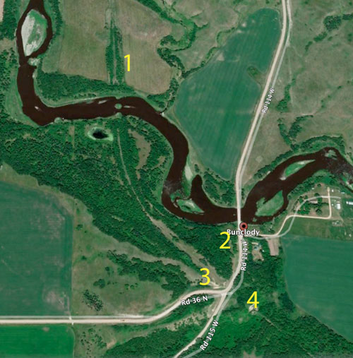
As you proceed southwards out of the valley you will pass the spot
where the railway crossed over the road. The elevator and station were
to the west (3) and to the east are the eroding remains of a huge fill
(4)where the line crossed a steep ravine.
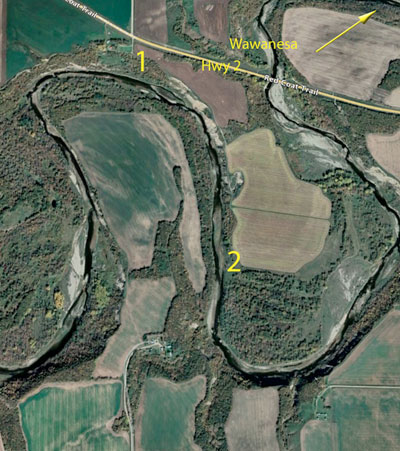
From Bunclody, head back to Highway 2 and go west to Souris. This
was the site of Plum Creek. Stop at the beautiful park near the
junctions of Plum Creek and the Souris River.
From Souris it’s a short drive to Harney via Highway 2 west and Highway
21 South. The Hart-Cam Museum, housed in the historic A.E. Hill Co.
Store is a must see for learning about the community.
Melgund
From there, continue south for just over five km. and turn west on
Melgund Road. It is fiver km. to the site of the Melgund Cemetery
and a cairn marking the Church (1) N49.42877, W100.57887
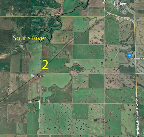
Note that when the railway arrived in 1890 it passed by Melgund,
although a siding called Emblem was later established. There was just
no need for a village between Hartney and Lauder, a few more kilometres
to the south.
From Melgund, the next site in the neighbourhood is Fort Desjarlais,
the most important fur trade post in the region. It requires a bit of a
hike (or paddle) so I have included it in the final section. If the
timing is right skip ahead and check it out.
To continue with this road trip as I have planned it, Napinka is your
next stop.
If you are feeling adventurous, or trust your GPS, proceed generally
westward until you find Road 254, follow it through Lauder (I recommend
you check it out (it won’t take long) then south to Road 22N, turn
south and you will find Napinka.
Less adventurous souls, can drive south to 345, and westward to Lauder
(worth visit) before taking 254 north.
Napinka
Napinka is a tiny village worth seeing. When I lived there in 1978 it
still had Grocery Store, A Post Office, three churches, two garages and
a railway station – today the Community Hall is still in use. In its
heyday its full compliment of businesses included The Winnipeg Photo
Company which has left us an impressive photo record of the early
1900’s.
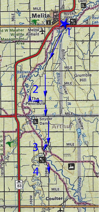
Melita
The next stop would be Melita. Check out the Antler River Historical
Museum. Walk the Main Street and note some of the older buildings still
in use. From there we set out roam the back roads south of town, to see
the final stops.
The Brockinton Site
First find the road headings south from the east side of the River on
Hwy3. (1)
Proceed to Road 13N, take a mile west, then north over a rough trail to
the site. (2) N49.20112, W101.03352. A trail leads from the year down
to the river’s edge. Each year the river uncovers more.
Coulter Park
(3) N 49.13575, W101.00811
Take note of the Fraser Cabin, the Alfred Gould House and have a good
look at the Interpretive Signs.
The Sourisford Linear Mounds
This National Historic Site is just a short drive south of Coulter
Park. (4) N 49.11686, W101.01711
While every site described in this tour could become an outdoor
adventure, or a good walk at the least. Combined with nearby
attractions, villages, and hiking trails etc. each site could be a day
trip in itself.
Some however and can only be fully appreciated by combining a day trip
with a good hike.
Gregory’s Mill
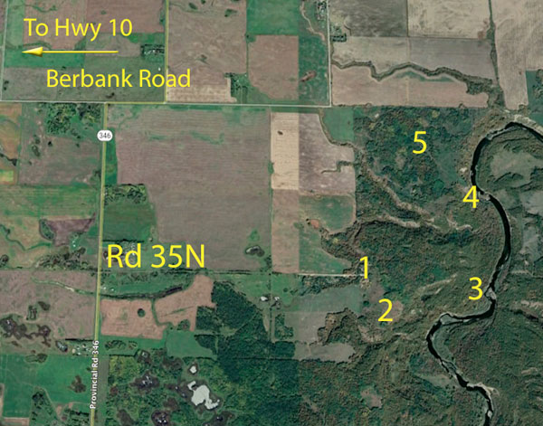
A trip to the site of Gregory’s Mill combines breathtaking scenery with
a chance to really immerse yourself in a significant historic location.
The easiest access if from Highway 10 to Berbank Road, about 35km.
south of Brandon. Proceed about 6 km east to Rd. 346. Go south,
the next grid road will have a Gregory’s Mill sign.
**Alternate routes include taking Rd 46 north from Highway 23, near
Margaret. Or take Rd. 346 south from Highway 2 near Nesbitt.
A recently upgraded access road takes you to a parking area used as a
base for equestrian trail rides. I start my hike there, but if you
prefer, a rough trail will allow you right to drive right to the
trailhead. (N49.514528, W99. 839442)
Stop to take in the panoramic view of the Souris River Valley before
beginning you trek down into that valley. The trail can be steep in
places. Soon after you reach the river the trail takes you alongside a
deep ditch. That is the millrace that carried diverted river water to
the mill. Predictably, I suppose, it takes you to that destination. You
won’t see a mill, but you should find the large Interpretive Sign
placed there by the Equestrian Club that maintains the trail, and the
extensive network of trails throughout the Souris Bend Wildlife
Management Area.
The Mill Site: N 49.524210, W 99.8288) is hidden in dense bush closer
to the river. All that is left are some elements of its foundation.
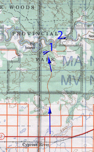
Fort Desjarlais
South of Hartney, Hwy 345 takes you west from Highway 21 to Lauder.
Just after the Lauder turnoff (1), Road 254 takes you north to
the Souris River. Just past the river (2) (N49.421560 W100. 726036), a
trail leads to the site of Fort Dejarlais. N49.436742,
W100.709969
The site is an open clearing alongside the river. In fact the
river has eaten away much of the site of the fort.
Alpha (Hog’s Back
Hiking Trail)
Fining the exact resting place of the riverboat Alpha might prove
difficult. As I explained in story, I was lucky to find it in the fall
of 2003 when the river was very low and the remains were visible along
the south bank of the river. Since that time, at least two spring
floods have dramatically altered the channel. In similarly low
water in 2021 the remains were only barely visible in the center of the
channel. They would disappear after the first rainfall.
It is possible however to get a good feel for the surroundings by
taking the Hog’s Back trail in Spruce Woods Park (1) N49.680442,
W99.063789. Some nice overlooks let one truly appreciate the
twisting nature of the river through the sandhills. A little used
branch of off the trail even leads you to a field across from where I
found the remains. Approximate GPS: N49.697601, W99.041878
For more information about these locations visit: Places
|

|
 |
 |
|
|