The First Crossing
About ten kilometers
downstream from where the northward-flowing Souris
River crosses the US border into Canada, a gravel ridge in the riverbed
forms a natural crossing that has been used for centuries. Bison herds
in their yearly migrations, Aboriginal Peoples on their hunting trips,
fur traders and Metis pemmican brigades - each used the site.
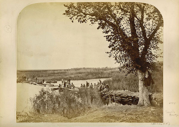
Bridge building on the Boundary Commission
Trail (Photo -
Archives of Manitoba)
Modern use of the
crossing began in 1873 when the British and United
States Boundary Commissioners followed a well-established route along
the 49th Parallel in their trek across the plains to mark the boundary
between the two nations.
A
careful survey had to be made of each stream for a suitable ford.
When they came to the Souris River they naturally selected this spot.
There was not only a firm bottom, but where the soft banks on each side
of the stream seemed to have been worn down by the immense herds of
Buffalo that were still roaming the plains, furnishing an easy approach
to the ford from each side of the river. Sourisford as the spot was
soon known, was on the map.
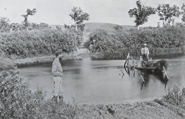
Approaching the Sourisford Crossing.
The Settlement
As the first European
settlers began arriving, the well-used crossing
was an obvious place for a village. T.B. Gerry’s blacksmith shop, on
the east side of the river, serviced the area. In addition to the Gould
– Elliot Stopping House, which served as a store and post office,
another store was operated briefly out of a tent by Warren &
Snider. R. M. Graham, already established in Melita, established a
branch store at Sourisford.
It
was poised to become the service centre for the region. In time it
was likely that other businesses would spring up and a few residential
streets would be surveyed.
A
comprehensive report from Sourisford appeared in the Brandon Sun on
May 22, 1884. It mentions that regular mail service had been
established, but because it was routed through Menota, where it waited
for two days to be forwarded, it was much less than satisfactory. Or,
as the writer says: “We were much better without it.”
Brandon Sun, June 6, 1884
The same issue expressed
the universal hope that a railway line would
soon appear and provide an accessible way to market the wheat crops.
The writer admits that there were, “little prospects of the
Southwestern being extended this year.” (In fact no railway would
appear for over six years). But the pioneers were always hopeful, and
some believed that, “J.J. Hill of the St. P.M. and M. Railway intends
making a personal inspection of the country to the south of the line
during the early part of this summer, with a view to extending the
branch from Devil’s Lake past Turtle Mountain and along the boundary to
the Souris.” As the writer admits, ”The present outlook is not
cheerful, but farmers are hoping for the best.”
We
learn that the County Registry Office has opened nearby – a sure
sign that settlement is progressing. Prior to its establishment the
neared land office was at Deloraine.
The
writer offers a hint that among all the speculation regarding “Boom
Towns”, the settlers themselves viewed such promotions with a skeptical
eye.
”The
county registry office is now completed, and the registrar is in
attendance everyday for the transaction of business. It is situated on
the town site of Souris (sec. 26.2.27). It is one of the famous paper
towns, and with this single exception consists only of a row of stakes.
The site is certainly a beautiful one, but that the next few
generations will see a village there is exceedingly doubtful. The
property is said to have sold for $40,000, and a good number of lots
have been disposed of.”
If
the railway line that connected Brandon with south-eastern
Saskatchewan in 1890 had crossed the Souris River at Sourisford instead
of Melita, that community would have thrived, and Melita would have
faded. But Sourisford remained a rural community, a Post Office and
Store – offering the necessary basic services, until 1901 when another
CPR branch stretched westward from Waskada and established Coulter a
few kilometres away. Sourisford then became one of dozens of Westman
communities that had served its purpose and was no longer needed as a
commercial centre. It did however remain its identity as a community.
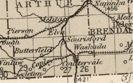
Sourisford – between two railway lines. From Atlas of Canada #19
1904
Sources
Melita:
Our First Century (Town of Melita and Municipality of Arthur),
Melita - Arthur History Committee
Sourisford:
"Sourisford and Area from 1879", The Sourisford
History Committee
Morran,
G.A. Souris River Posts , The Souris Plaindealer
Clarke,
Lawrence, Souris Valley Plains. A History, Hartney Mb.
Turtle
Mountain - Souris Plains Heritage Association Vantage Points I,
II, III, & IV