by Gordon Goldsborough, Russ Gourluck, Rob McInnes, Giles Bugailiskis and Randy Rostecki
Winnipeg, Manitoba
|
Postcards in the early part of the twentieth century were frequently used as a convenient vehicle to carry greetings and brief messages to friends and family living in other parts of Canada or in other countries. As an alternative to telephone and telegraph, postcards were a relatively inexpensive way of communicating when the speed of transmission was not an issue. As an alternative to mailing letters, sending postcards permitted messages of only a few words—an advantage when the sender had little to say or was writing primarily out of a sense of obligation. The pictures, rather than the handwritten messages, were often the real highlights of postcards, especially before inexpensive cameras and film processing became common. They were intended to enlighten the recipients and perhaps to arouse some feelings of envy for the vacation travellers or proud residents who sent the cards. To achieve these results, postcards utilized images that showed off a community’s most attractive and photogenic features. One noteworthy aspect of this effort is that very few postcards views of Winnipeg show snow, an artful denial of the realities of several months of each year.
Postcards were used in Canada as early as 1871, but people were permitted to write only the recipient’s address on them and nothing else. Finally, in 1903, the post office authorized “divided back” private postcards, where one half of the card provided space for the address, with space for a written message on the other half. The reverse side usually featured a photograph which, before true color photography, were often painted with colors resembling those of the original. Many companies got into the business, and the “golden age” of the postcard was at hand. In the years leading up to World War I, thousands of different postcards were created and millions were sent. Their broad subject appeal, their novelty in an otherwise black-and-white world of images, and their personal connection with the sender were all factors promoting their retention, long after the message they conveyed became irrelevant. Numerous postcards from early 20th century Winnipeg exist in collections around the world, providing useful—and in many cases, unique—views of the growing city.
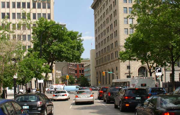
It is understandable that these postcards presented views of the city’s heart, mostly focusing on buildings on major downtown thoroughfares. Until at least the 1950s, Winnipeg’s downtown was the community’s hub of commerce and entertainment. Two landmark department stores, Eaton’s and Hudson’s Bay, proudly stood a few blocks apart on Portage Avenue and were beacons that drew countless thousands of residents and visitors downtown every day. Hundreds of other shops along and near Portage provided even more shopping opportunities that couldn’t be found anywhere else in the city. The famed intersection of Portage and Main, with its nearby Bankers’ Row, Great-West Life, and the Winnipeg Grain Exchange, symbolized the early wealth and commercial prosperity of Winnipeg. Dining at Child’s, Moore’s, the Chocolate Shop, and dozens of other restaurants, or nights out at palatial movie houses like the Capitol, the Metropolitan, and the Odeon, ensured that Winnipeg’s downtown was a busy and exciting destination even when the retail stores were closed.
Implicit in these photos is the outward movement of Winnipeg’s population, especially during the 1950s, 1960s, and 1970s. Until then, most Winnipeggers lived, worked, and shopped in or near the core area of the city. There are few vintage postcards of the “suburbs” (as areas like East, North, and West Kildonan, Fort Garry, and St. James came to be called) not just because they would have offered relatively uninteresting views of streets and houses, but also because many of those areas were essentially rural at the time these postcards were produced. Some of the less desirable changes in Winnipeg’s downtown (exemplified by gone-and-not-replaced buildings) are the result of the movement of the city’s life blood away from its centre.
People do appear at a distance in some postcards, but their presence is clearly incidental and offers limited opportunity to study interesting features like clothing styles. Methods of transportation are also of secondary importance, but examination of the postcards and the current photos suggests several developments. The presence of cyclists (and even bicycle parking areas) are reminders that bicycles were a popular means of transportation in the early 1900s—and a technological step forward from the still-prevalent horse and buggy. Streetcars were a common sight on major Winnipeg streets until their elimination in 1955, evidence t h a t most Winnipeggers relied on public transit (including trolley and diesel buses) until at least the midpoint of the century. The relative absence of buses in the current photos illustrates that the family car has replaced public transit as the primary mode of transportation (and reduced both the need and the desire to travel downtown).
But the primary focus of all of these images, old and new, is buildings, and seeing the same scenes from the same points of view with a century between them reveals an interesting mix of difference and sameness.
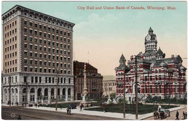
The most dramatic kind of difference is the elimination of a number of landmark structures and the failure to erect anything in their place. Nostalgia for buildings like the Royal Alexandra Hotel, the Empire Hotel, and the McIntyre Block can only be accentuated by the vacant lots that remain. Other buildings, like the quirky “gingerbread” city hall and the once-phenomenally-popular Eaton’s department store, have at least been replaced by the current city hall and the MTS Centre.
The Union Bank Building, constructed in 1905 next to the Leland Hotel and the “gingerbread” City Hall, still stands in 2007, unlike its neighbors.
Source: Rob McInnes, WP0352
Other photos can remind Winnipeggers of landmarks that still stand (and are now protected by law) but have an uncertain future (including Upper Fort Garry Gate, the Union Bank Tower, and the Metropolitan Theatre).
Perhaps the most encouraging photos are historical buildings that not only are intact, but have exciting new leases on life. Wesley Hall is the heart of the University of Winnipeg. The Millennium Centre, the Birks Building, and the Walker Theatre exemplify how the heritage of buildings can be preserved and respected at the same time as changes enable them to thrive in the 21st century. Elim Chapel suffered a disastrous fire yet emerged strong and vibrant. The transformation of the Canadian Pacific Railway Station into the Aboriginal Centre of Winnipeg demonstrates not just the passing of railway passenger travel but the increasing pride and influence of First Nations people.
As much as some of these old-and-new pairings demonstrate visible differences in downtown Winnipeg, others provide an almost-eerie impression of sameness. Some views of sections of Main Street and the Exchange District are almost identical, despite the passage of over a hundred years. Although observers who equate progress with an ongoing cycle of demolition and construction will see these views as evidence of stagnation, heritage advocates will take justifiable pride in seeing the extent to which Winnipeg’s built history has been preserved.
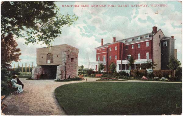
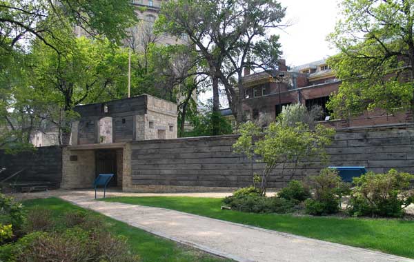
The Upper Fort Garry Gate is one of the most historic areas of Winnipeg, and also one of its most neglected. The site is concealed by trees, adjacent buildings, and a gasoline filling station, visited mostly by smokers from the Fort Garry Hotel, which is visible in the background of the modern photo but absent in the postcard view, having been built by the Grand Trunk Pacific Railway in 1913. The gate’s fate was sealed when, in 1870, troops of the Wolseley Expedition approached Fort Garry, looking for Louis Riel and his provisional government. Manitoba became a province soon after, settlers arrived from all over the world and, in the boom that saw Winnipeg grow from a cluster of shacks to a major urban centre, the Hudson’s Bay Company saw little need for an old stone fort to protect its interests. The fort’s walls and bastions were demolished in 1881, and their stones were re-used for the foundations of numerous buildings around the city, including the company’s 1881 store at the corner of York Avenue and Main Street. Four of the fort buildings were moved to the HBC mill on the Assiniboine River. Other buildings, such as the former Governor’s residence, were torn down in 1888. Nine years later, the remaining north gate and a small parcel of land was transferred to city ownership. The Manitoba Club opened a clubhouse next door in 1905, then enlarged it in 1909. The gate was further bracketed by the 1947 construction of the Imperial Oil Company building at 100 Main Street (now owned by the city), and the Grain Exchange Curling Club in 1948. The remainder of the old fort site was covered in parking lots, and Main Street itself. The gate sank into obscurity and became a target for vandals and graffiti “artists.” Its wooden gates were stolen, as was a bronze cannon. In the mid-1940s, the Manitoba Historical Society, newly re-awakened after going into hibernation circa 1936, called for restoration of the gate site. Not much happened. By the 1980s, the gate was badly in need of repair. Work was done in 1983, and interpretive signs and a replica wood wall were added. Recently, renewed interest in the gate is coinciding with the closure and sale of the encroaching civic building. The “Friends of Upper Fort Garry” are lobbying for the site to become a heritage park, rather than a high-rise condominium approved by the city council. The final chapter in the Upper Fort Garry Gate saga remains to be written.
The Upper Fort Garry Gate, with the Manitoba Club in the background (circa 1907)
Source: Gordon Goldsborough
The Upper Fort Garry Gate, with the Manitoba Club in the background (2007)
Source: Gordon Goldsborough
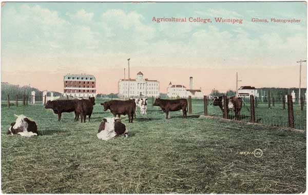
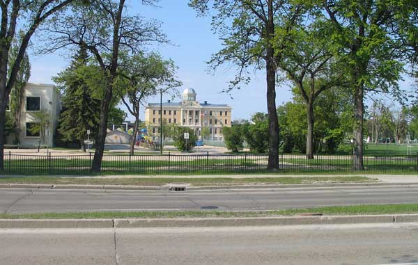
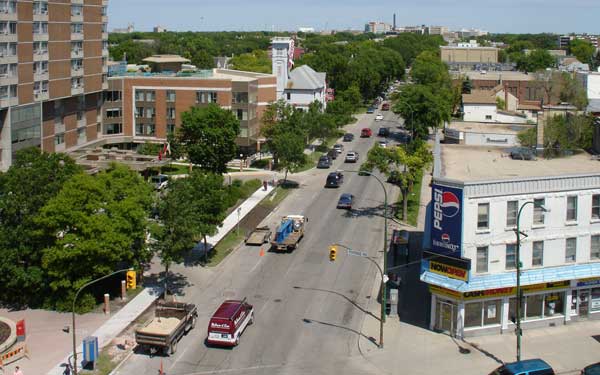
Occupants of the present Asper Jewish Community Campus might hardly recognize the pastoral scene in this postcard, were it not for the distinctive building in the centre. Several years before Tuxedo was developed as a residential suburb, the provincial government established an agricultural college on the site south of the Assiniboine River, in 1906. Designed by provincial architect Samuel Hooper, it was the first such college in western Canada, and only the third in Canada. Among the college buildings was Roblin Hall, the red building at left, constructed circa 1907 and named for premier R. P. Roblin. The college offered courses in horticulture, agricultural engineering, animal husbandry, farm management, and home economics. A short six years later, it had outgrown the site so the college moved to a larger site south of the city. There was public outcry over the abandonment of perfectly good buildings in Tuxedo. They were used from 1914 to 1917 by the Manitoba School for the Deaf, then the site was used for a short time by the federal government as a convalescent and rehabilitation hospital for war veterans. When Deer Lodge Hospital was built on the opposite side of the river, the site became Fort Osborne Barracks. By the 1950s, the army moved to the south end of the property to start Kapyong Barracks. The provincial government began taking over, which it had completed by 1968. Roblin Hall was demolished in the early 1980s, by which time it had been severely vandalized. Late in its life, purple dye for coloring gasoline intended for farm use was stored there, and vandals had made its interior a colorful mess. In the early 1990s, the site was re-developed as an educational and recreational facility for Winnipeg’s Jewish community. Meanwhile, the surrounding area was being developed. In 1913, the Town of Tuxedo was incorporated with real estate developer Frederick W. Heubach as its first mayor. The town layout was designed by the American landscape architectural firm of Olmsted Brothers, with spacious homes set in extensive gardens. After Heubach’s death, he was succeeded as mayor by David R. Finkelstein, who was active in municipal affairs until 1951.
Tuxedo Avenue west of Kenaston Boulevard, site of the Manitoba Agricultural College (circa 1910)
Source: Rob McInnes, WP0833
The Asper Jewish Community Campus (2007)
Source: Gordon Goldsborough
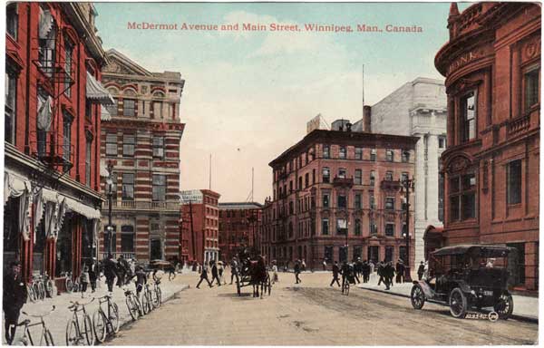
The diversity of transportation options in early Winnipeg is evident in this postcard, where bicycles shared the road with horse-drawn carriages and automobiles, the latter a recent innovation. The car’s dark-colored licence plate with light numerals (#941) means this is 1912, and a database of vehicle owners for this year tells us this one belonged to Frank L. Patton, manager of the Winnipeg branch of the Dominion Bank. Patton must have parked his McLaughlin car where he could keep an eye on it, for the Dominion Bank building (demolished in 1966) appears at right. Across Main Street, opposite the Dominion, was the first Hamilton Bank building. It developed severe foundation problems caused by construction of the massive Bank of Commerce building next door (opened in Autumn 1912; now the Millennium Centre) so that, starting in 1916, the present structure was constructed as a replacement. Winnipeg’s second post office building (constructed in 1886) was replaced by the 1963 building occupied now by the Canadian Wheat Board. At left in the postcard is the Caldwell Building, built in 1879 as the first four-storey building in the city. It was noteworthy for another city first: in 1881, a telephone switchboard was installed in a small room on its top floor, to simplify running telephone wires to it. The building towered over its neighbors until the boom of 1881-1882, when several tall structures were erected nearby. The Caldwell was reduced to two storeys by a 1918 fire, was refaced in the 1940s, eventually confiscated by the City of Winnipeg for unpaid taxes, and ultimately demolished to make way for a parking lot in 1999. A few buildings in the center of the 1912 view remain in 2007, the most evident of which is the Porter Building—distinguishable in 1912 by the white sign at its top—in the centre of each view. The Porter was home to a wholesale crockery and china firm when it was constructed in 1906. Noteworthy by 2007 are trees, traffic lights, many more cars, and one-way traffic on McDermot.
McDermot Avenue west of Main Street (1912)
Source: Rob McInnes, WP0512
McDermot Avenue west of Main Street (2007)
Source: Gordon Goldsborough
Was the doctor making a house call? In this view, also from 1912, an automobile challenges a horse-drawn carriage for dominance of the street. The license plate number (#112) tells us the owner of this Paterson car was Dr. John E. Coulter. He lived on Maryland Street, and may have been visiting a patient in the Breadalbane Apartments (renamed the Ambassador in 1928), visible at the right of both views. The block had been built in 1909 to meet the growing demand for middle-class accommodation from the city’s burgeoning population, including many transient residents. (An alternative—especially for women and short-term residents—was to board with a family, and the 1911 Canadian census shows many Winnipeg homes with one or more boarders.) Built by entrepreneurs John D. McArthur and James Fisher, and named for Fisher’s birthplace in the Scottish Highlands, the Breadalbane had twelve bachelor, one- and two-bedroom suites on each of its five floors. The original plans called for a fifth floor restaurant which was never built, although a smoking lounge was added later. The residents were relatively affluent. At least two owned automobiles in 1912; one was a manufacturer’s agent, the other was a railway inspector. The surrounding area beyond the building was still largely residential. Eventually, however, entire streets of single-family residences would be replaced by apartment blocks, such as the one built across the street in the 1920s. The external apperance of the Ambassador has changed only slightly: shutters are gone, a thirdfloor verandah is enclosed, and an entrance canopy was added in the 1940s.
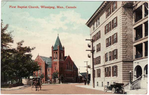
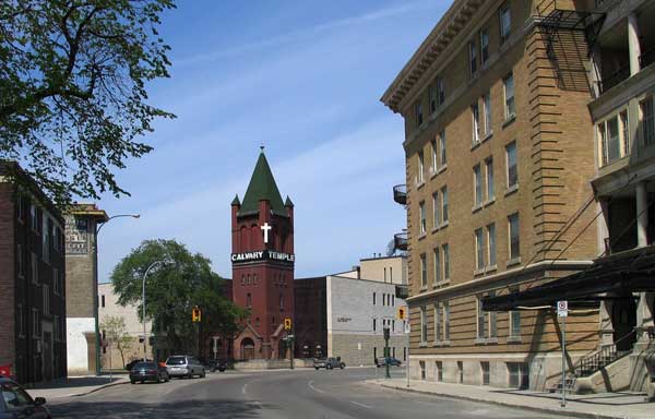
Featuring prominently in the centre of both views is the bell tower of a church, constructed in 1892 and doubled in size by 1904. In 1938, economic depression and migration of congregants to the city suburbs had diminished the church’s resources so the Baptists sold the building to an evangelical Pentacostal sect—which had met in other premises starting in 1907—and the building was renamed Calvary Temple. A Sunday School building was added in 1955, and an education centre joined it in 1962. Twelve years later, a new large temple was built next door, and the original church building was demolished in 1985, except for its bell tower. Calvary Temple celebrated its 100th anniversary in May 2007, shortly before the bottom photograph was taken.
Hargrave Street at Qu’Appelle Avenue (1912)
Source: Rob McInnes, WP0152
Hargrave Street at Qu’Appelle Avenue (2007)
Source: Gordon Goldsborough
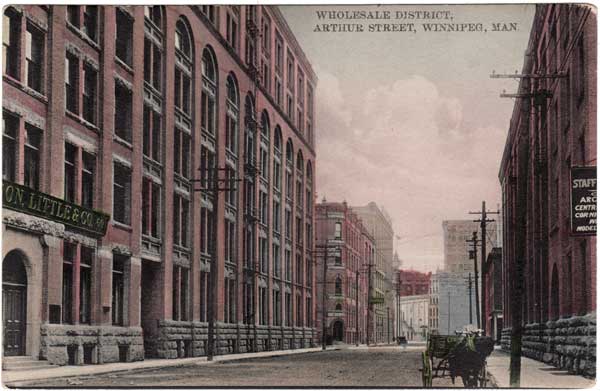
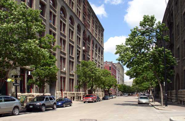
Some views of Winnipeg are remarkably unchanged in 100 years. Nearly every building visible in this postcard of the Exchange District is still standing. The massive structure at left is really two buildings: Robinson, Little & Co. at left (built 1903-1904) and the Whitla Building at right. The Whitla was built in 1899 for the wholesale dry goods firm of Robert J. Whitla. Sold in 1947 to a sportswear manufacturer, it became the Silpit Building about 1970. More recently, its cavernous floors have been subdivided to provide homes for numerous smaller businesses. Further down the street on the left is the Stovel Building—erected in 1893 for a printing firm that was noteworthy as the first in western Canada to print in color and use presses run by electricity. The building was extended by two storeys and down the block in 1900, gutted by fire in mid-1916 then rebuilt, now called the Kay Building for the dry goods firm which occupied it in 1940. At the left back, the A. F. Gault & Co. Building was constructed in 1900, extended in 1903 with two more floors and a six-storey addition, and renovated in 1986 for use by Winnipeg’s arts community, and known now as ArtSpace. The “gingerbread” City Hall (constructed 1886, demolished 1964) peeks through at the back of the postcard, flanked at right by the 1905 Union Bank building, thought to be the oldest surviving steel and concrete skyscraper in Canada—now standing vacant. Other survivors along the right side of the street are concealed by trees which have replaced utility poles lining the 1912 street. Among them is the Alexandra Block, built in 1901. Its retail shops and apartments occupied the entire block between Albert and Arthur Streets. It was later sold to Frank Mariaggi who had arrived with the 1870 Wolseley Expedition. Mariaggi converted the building to a hotel, in the basement of which was “The Grotto” restaurant, built to resemble a European cave. He sold out in 1908, returning to his native Corsica as a wealthy man. The building remains a hotel today. In the foreground right is the Merchants Building, built in 1898 as a warehouse for the hardware firm of G. D. Wood & Co., later renamed the Wood Vallance Co. Like the Whitla, it is now subdivided for multiple use. For three years ending June 2007, it housed the MHS office.
Arthur Street south of McDermot Avenue (circa 1912)
Source: Giles Bugailiskis
Arthur Street south of McDermot Avenue (2007)
Source: Gordon Goldsborough
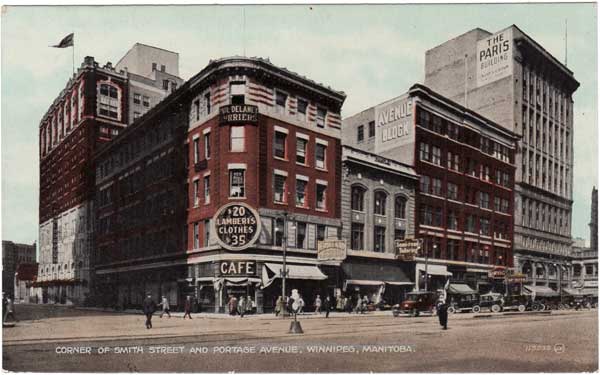
The Kensington Building is the only major change to this Portage Avenue streetscape. Built in 1905, it burned in 1972 and was replaced with a glass and steel tower. Behind it is the Marlborough Hotel, which has grown from its 1914 origins as the three-storey Olympia Hotel built by four Sicilian immigrants, two of whom had operated the Olympia Café on the first floor of the Kensington. Within six months, economic factors forced the hotel to close. It was then used to house soldiers. By 1923, five floors had been added, and new owners renamed it the Marlborough. An annex on the north side was added in the late 1950s. Three buildings on Portage Avenue are, from left to right, the Hample Block (1906-1907), Avenue Block (1904), and Paris Block (1915-1917). The Hample has the distinction of being the first building built by a woman, Martha Jane Hample, a wealthy widow who ran a catering business. Mrs. Hample was also politically active as a member of the Political Equality League, which lobbied the provincial government for female suffrage. Other founding members included Nellie McClung, Lillian Beynon Thomas, and Cora Hind. Hample was the first female member of the Winnipeg School Board and, in 1907, she helped to found the Knowles Home for Boys (now the Knowles Centre) to care for abandoned and orphaned boys. Hample sold her namesake building in 1918, but the name has “stuck.” The Avenue Block’s original owners were also prominent Winnipeggers. Real estate developer Mark Fortune lost his life aboard Titanic, and Daniel H. McMillan was the province’s Lieutenant-Governor at the time of the building’s construction. The top three floors were added in 1912, and the entire building was rebuilt after a disastrous 1931 fire. The Paris Building was erected in two phases: the bottom five floors went up in 1915, and the remaining six were added in 1917. It was built by the construction firm Carter-Halls-Aldinger, who were responsible for numerous other buildings of early Winnipeg, including the Electric Railway Building on Notre Dame Avenue (now home to the provincial government’s Historic Resources Branch), the Free Press building on Carlton (now abandoned by the paper for a facility in the suburbs), and Minto Armouries on St. Matthews Avenue. By the time all eleven floors were constructed, the Paris was one of the tallest buildings in Winnipeg, making it a dominant feature of Portage Avenue. Of course, it is now dwarfed by several neighboring towers.
Smith Street and Portage Avenue (1920s)
Source: Giles Bugailiskis
Smith Street and Portage Avenue (2007)
Source: Gordon Goldsborough
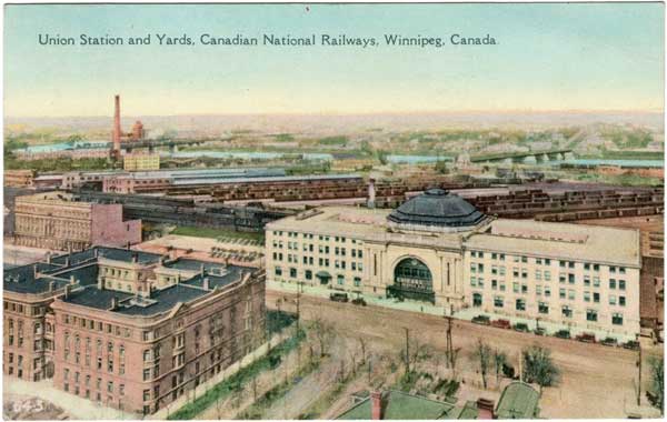
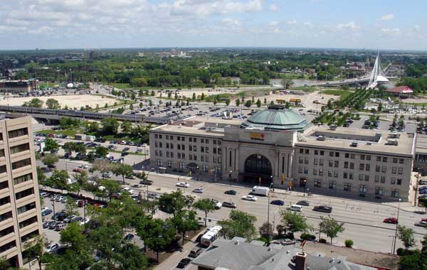
These two views of the historic Forks area were taken from the roof of the Fort Garry Hotel, but the roads, Union Station (so named for its two railways: Canadian Northern and Grand Trunk Pacific) and the Manitoba Club (whose roof is visible in the right foreground) are the only major elements in common between them. Gone are the extensive railway yards, the Fort Garry Court apartment complex in the left foreground, and the Empire Hotel on the left side. Built in 1902 and originally named Strathcona Court in commemoration of business tycoon Donald A. Smith, the Fort Garry Court was intended, in the words of a newspaper account, to “surpass anything of its kind in Canada.” A central open court was by bounded on four sides by blocks. It featured a bandstand, apparently to entertain the residents, who included many of Winnipeg’s professional elite. Among them was bachelor realtor Charles H. Enderton who developed the Crescentwood area. The building met a fiery end in February 1976 when it burned, killing five and leaving 175 homeless. Fire was also a factor in the early history of the Cauchon Block, which featured a unique cast iron and sheet metal façade manufactured locally at the Vulcan Iron Works. Built in 1882 as an office building for Manitoba’s first francophone Lieutenant-Governor Joseph E. Cauchon, it was later remodeled into the first apartment building in Winnipeg, serving the needs of single young men, a few families, and a dance school. It burned three times, in 1885, 1895 (after which it became the Assiniboine Block, with renovations supervised by architect Charles H. Wheeler), and 1897. Under the proprietorship of the McLaren brothers, who later opened a hotel further down Main Street which still bears their name, it became the luxurious Empire Hotel. The hotel closed in the mid-1970s and was taken down in 1982. Much of its façade was damaged during demolition although some portions were saved and are now displayed at the Société historique de Saint-Boniface. Additions to the modern scene are the Esplanade Riel over the Red River in the background, the Goldeyes baseball park at the left rear, and the executive office tower of the Wawanesa Mutual Insurance Company at extreme left. Founded in 1896, and still headquartered in the village of Wawanesa, the firm received an MHS Centennial Business award in 2000.
The Union Station at Broadway and Main Street from the roof of the Fort Garry Hotel (1920s)
Source: Rob McInnes, WP0634
The Union Station at Broadway and Main Street from the roof of the Fort Garry Hotel (2007)
Source: Gordon Goldsborough
Not all Edwardian postcards were colorized like the preceding examples. This black-and-white photo was taken from the roof of the Casa Loma (“house on a hill”) Building. It was designed to provide retail space on the first floor, including a branch of the Dominion Bank, and four floors of apartment accommodation. An April 1928 fire killed five people, including a fireman. A subsequent inquiry identified several factors as contributing to the blaze: exterior fire escapes had been removed, the Casa Loma’s firefighting equipment was poorly maintained, flammable garbage had accumulated in and around the single elevator, and the elevator shaft was made of wood. These problems led to calls for revision of building codes. The building at left is the second Deaf and Dumb Institute (later, Manitoba School for the Deaf), built after the first one—just a year old—was damaged by fire in October 1891. The architect for both buildings was Charles H. Wheeler whose many commissions included two Winnipeg building that have been designated as national historic sites: Holy Trinity Church at Graham and Donald, and Dalnavert, the 1895 home of politician and judge Hugh John Macdonald. The first Principal of the Deaf School was Duncan W. McDermid, who came to be known as one of the continent’s foremost authorities in education of the hearing-impaired. His son, Howard, would take over as Principal after his father’s death. The part of the building visible in this view was known as McFadden Hall. In 1914, the school moved to the site of the Manitoba Agricultural College before moving to a building in Tuxedo that is now part of the Canadian Mennonite University campus. Its building on Portage Avenue was given by the provincial government to the University of Manitoba for use in its Engineering program, which eventually moved to the Fort Garry Campus in the 1930s. McFadden Hall was demolished in 1964-1965 and its site was occupied by Lion’s Manor, a residence complex for senior citizens and students from the nearby University of Winnipeg. The building farther down Sherbrook on the left was Fire Hall No. 5 (distinguished by its characteristic tower, used to drain and dry fire hoses), built in 1904 during a spate of fire hall construction. Like several others around the city, the old hall is now used for other purposes; in this case, by an automotive glass firm.
Intersection of Sherbrook Street and Portage Avenue from the roof of the Casa-Loma Building (circa 1910)
Source: Rob McInnes
Intersection of Sherbrook Street and Portage Avenue from the roof of the Casa-Loma Building (2007)
Source: Gordon Goldsborough
See also:
MHS Historical Features: Winnipeg, Then and Now
Page revised: 2 September 2015