| Index |
|
4. Around
the Neighbourhood - Communities
 A look at a map from 1885 helps us understand a bit about life in the early 1880’s in the Wakopa region, and across western Manitoba. The railway line from Cartwright to Boissevain had just been completed. The towns of Boissevain and Killarney had just been created overnight by decision of the railway company as to where to run the line and where to establish stations. Aside from the few new railway villages, nearly all the other names on this map mark the locations of Post Offices. Souris City and Millford to the north thrived for a short time, Millford because it was a departure point for travellers coming from Winnipeg via Assiniboine River steamboats, Souris City because it was at a crossing of the Souris River. Neither survived the coming of railway lines. Souris, originally Plum Creek, was one of the few places where the railway entered an established settlement, and Deloraine survived by moving a few kilometres to be on the rail line that arrived in 1887. When the first settlers arrived they had quite a to-do list. Priorities were to build some shelter, then break some sod and plant some grain and vegetables. They were, of course, very busy. When they did have time to take a deep breath and think ahead, they would get together and build a school. One thing they often didn’t do right away was build a town. They might build a church, and then, if the population warranted it, and someone was of an entrepreneurial turn of mind, a general store or a blacksmith shop might open for business. But most such settlements never did become towns as we know them, with a grid of streets and a main street set for commerce. So most of rural Manitoba was indeed rural (and local) in every sense of the word. Towns came later when railways brought easy access to supplies, and each district needed a centre to access those supplies. So as far as creating towns, Wakopa was ahead of the curve as they say. But travel was time-consuming and the region surrounding Wakopa was still made up of communities and locations, each with their own identity. Next to Wakopa, the name on the map most widely known was Desford. Early on, was the only other place nearby that had a store. The Two Desfords An Englishman named Barneby did a tour of North American in 1883. He passed through Brandon and then went south. In the book he published, he mentioned one of the little villages that came and went in those early days. “On our route we passed a store named Desford, where we watered our horses; but the water was bad. A road comes in here from Brandon. The Turtle Mountains are still to the south.” That’s about all he had to say, but the settlement got a mention. The Desford community began in the late 1870's along the Old Commission Trail about twelve kilometres south of Boissevain, and was, after Wakopa, the second trading centre in the area. People living where Boissevain would soon be located would do their shopping and get their mail at Desford, in the store opened by E. Nichol. The first Church services were held at James Burgess’s log house. 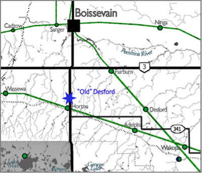 More Claims to Fame…. Duncan Henderson recalls: “Practically all our travel was done on foot and I have walked to Old Desford, eleven miles distant, for the mail and shouldered a hundred pound sack of flour back. “ Mrs. A. E. Cook recalled: “There were no stores where food could be purchased, nearer than Brandon, except those at Desford, Wakopa and Waubeesh. “ Desford seemed ready to become an important town if only the railway would pass through. That didn’t happen. The railway passed to the north and the town of Boissevain became the centre of the region. A Second Life…. In 1906 the Great Northern Railway was put down through the area and a small village, a few kilometres east of the original spot, but also called Desford, sprang to life. In 1908 the hamlet consisted of the water tower for the trains, the Railway Station, elevator, section house, bunkhouse, the Methodist Church, the blacksmith shop, a Community Hall, a General Store and a few houses. It was a community in every sense and like so many others was a busy place for a time. The population exploded to near thirty. The local retail businesses thrived. 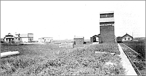 Desford: In the period 1908 – 1925 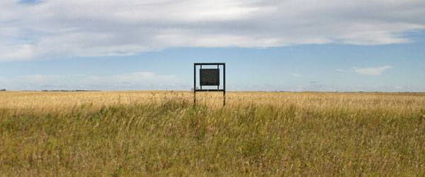 All traces of Desford are gone. This sign, placed in 1970, is left to remind us of an earlier time. The following map tells as a lot about what the essential services were in a village like Desford. 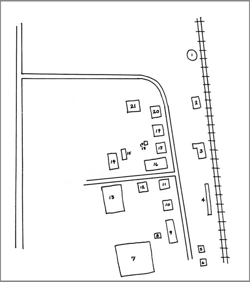 1.
Water Tower
2. 2. GN Station 3. 3. McCabe Elevator 4. Loading Platform 5. Section House 6. Bunk House 7. Ball Diamond / Picnic Site 8. Church Barn 9. Anglican Church 10. Bridger House 11. McDonald House 12. H. Bridger, Blacksmith 13. Desford Hall (Former Shoe Shop) 14. Methodist Church 15. Church Barn 16. Skating Rink 17. Davis Store 18. Oil Shed 19. Warehouse 20. 1st Site, Neuman Store 21. J. Bridger. Sr. Blacksmith In many ways, such villages never recovered from the depression, but that merely hastened their inevitable decline. An all-day trek to Boissevain with a horse and buggy over muddy trails, soon became a ten-minute drive over graded gravel roads. The businesses were the first to go, while the social activities remained vital for another few decades. By the 1950’s there just weren’t enough people for a good school dance and the village faded away. The Fox Sawmill In 1880 the Fox family, from Ontario, came to Millford (at the confluence of the Souris and Assiniboine Rivers) and then south to Turtle Mountain. A neighbour allowed them to live his small log shack in the Wakopa area. Thomas and his oldest son Alfred set up a sawmill two miles north-east of Lake Max. People came from many miles around to use the lumber that was produced from this mill. In 1881 Tom decided to take a homestead nearby and settled (on 10-2-19) several miles west of Wakopa in the Adelpha area. In 1884 Tom moved his sawmill west where it was used to cut lumber for the growing CPR. The mill was dismantled and hauled to Brandon where it was shipped to Calgary. Tom went along with his mill while his family stayed behind and his son Frank took over the homestead. Adelpha Adelpha originated as a post office in the home of an early homesteader, John A. Hurt. He settled just to the north of the Turtle Mountain Forestry Reserve, right beside the Boundary Commission Trail. In the early 1880s Frank Kingdon came to the area to settle. He had a store and brought implements into the region to sell to farmers. In 1904 the Canadian National Railway built a rail line heading southwest from Greenway into southwest Manitoba. In that year the railway was built from Neelin as far as Turtle Mountain. The rail reached as far as the section to the northwest of Hurt's home and post office and stopped there. A “Y” was built at Adelpha for turning trains around so that they could head back east. The train station was named Adelpha and built on that section. At the “end of the line” Adelpha became a commercial hub and center. It served as a neighbourhood shipping point. Adelpha was an important center until 1914 when the CNR extended the Greenway Branch to reach Deloraine. Lena On a modern map, Lena is the village closest to Wakopa, the next stop to the east on the new rail line. It too had existed as a post office until the village was was created by the CN Branch line. On the 1885 map above Lena is not included. The Lena Post Office didn’t open until 1892, and was first situated about one mile south of the present village. The name itself however, is much older however, dating back to an HBC Post that operated for a short time one the SE corner of Turtle Mountain. 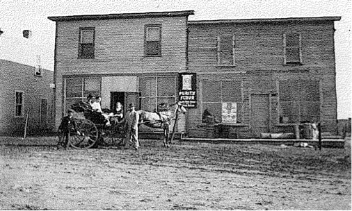 A, B. Langenfield built the first general store, shown here in 1915. A hotel was built beside the store and was operated by George Forester. This was a short-lived project and later was used as a hall. The Young Elevator came into existence shortly after the railway came through. It was later bought by the Paterson Co. The Pool Elevator was organized by local farmers in 1928. Doug Trevers moved his International Harvester Co machine business from Bannerman to Lena in 1924. He later branched into the Imperial Oil and general store business. When his building burned in 1957 the Atchisons moved the former Great Northern Station down from Bannerman, locating adjacent to No 18 highway. In 1968 they sold it to Bert and Ivy Ames who operated it until selling out in 1970. This was the end of the Lena General Store. The Post Office, usually operated by the storekeeper, was closed in 1976 The first school was built in 1907 and was replaced in 1951. In the late 40's Lena had a high school with Grades 7 - 11 taught in the Church. Church services were held in the school until 1925 when the Lena United Church was built. Although it was officially a United Church, people of other faiths attended and supported it. The village blacksmith shop, run by Joe Bates (1908-1923), was an important part of the community. Dances in the hall and school, fowl suppers and concerts in the church, a skating rink in the late 40's, a ball team and picnics all kept the community active. The closing of church and school changed the social habits of the people. A 'beef ring' operated out of Lena in the 1920's. Andy Miller was the first butcher with Dave Pyper succeeding him. The beef ring was a non-profit venture which enabled the people to have fresh meat every week from May to September. Lake William The first settlers near Wakopa heard from the local Aboriginal people about a lake near the "Turtle's Back, a landmark visible far and wide. At some point five of those settlers, William Ryan, William Shannon, William Boyd, William Hewitt and William Anderson decided to cut a road through the bush to the lake. Upon reaching the lake they decided to name it after the first name they all had in common: William. Their efforts to clear a road to Lake William made the lake accessible to other early pioneers of the area. The lake was a popular spot to fish and pick wild berries. Today the lake boasts a small beach, camping and access to surrounding hiking trails, including the popular Turtle's Back, which offers an impressive view from the top. There is a no-motorboat policy on the lake, making it a quiet and peaceful retreat. |
