 Map Collection: Settlement Theme  S1. Hind 1859 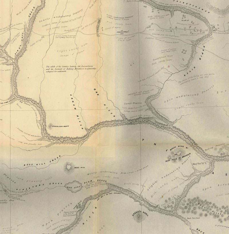 Hind 1859 http://www.flickr.com/photos/manitobamaps/3808734146/ Map of a Portion of Rupert's Land Surveyed and Examined by the Assinniboine & Saskatchewan Exploring Expedition in the Year 1858 [Sheet 3] (1859) Hind, Henry Youle. Map of a Portion of Rupert's Land Surveyed and Examined by the Assinniboine & Saskatchewan Exploring Expedition in the Year 1858 Under Instructions from the Provincial Secretary Canada [Sheet 3] [map]. 1:443,520. In: Henry Youle Hind. North-West Territory Reports of Progress Together with a Preliminary and General Report on the Assiniboine and Saskatchewan Exploring Expedition Made Under Instructions from the Provincial Secretary Canada. Toronto: John Lovell, 1859. Henry Y. Hind in charge fo the Expedition. James A. Dickinson, Surveyor & Engineer. John Fleming, Assist Surveyor & Draughtsman. Engraved by Maclear & Co. Lith. Toronto. The dotted lines shew those parts not not actually surveyed by the Expedition, some being taken from Thompson's Map, such as the East Coast of Lake Winnipeg & the Northern portion of Lake Winnipegosis and some information obtained in the Country. The continous lines shew those portions of the Country which were actually surveyed. The original maps are on two large sheets and as a result of scanner size constraints they have been scanned in four sections with overlap for display online. Both H. Y. Hind and S.J. Dawson prepared vast maps showing the accomplishments of their explorations, and one of the most interesting features of these maps is the manner in which relief is depicted. Hind used hachures to show Riding Mountain, and the technique is very appropriate for that purpose. The map also demonstrates how Hind’s observations were centred around field mapping, and how comprehensive was the data which he collected. Vegetation is mapping, sloughs are indicated in the till plain south of Riding Mountain, geological formations are marked, and cart trails are shown on the ridges so that one can see that they are used for travel. Soundings are shown along the west shore of Lake Winnipeg. Much topographic information is entered in the form of written comments and many of the observations, such as “Vast Level Prairie adapted for Agriculture”, were reproduced in countless maps to follow. The Portage Plains, destined to be one of Canada’s great agricultural districts, are designated “Rich Clay Loam”. A special terminology is occasionally used, as when the phrase “Oak Orchards” appears. (Warkentin and Ruggles. Historical Atlas of Manitoba. map 91, p. 220) Image Courtesy of University of Manitoba Archives & Special Collections Manitoba Historical Maps - Flickr Back to INDEX S2. Laurie's 1876 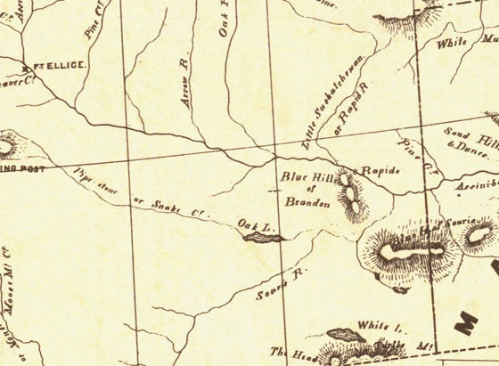 Laurie 1870 NWT http://www.flickr.com/photos/manitobamaps/2231443980/ Laurie’s Map of the North-West Territories (1870) Donald Codd emphasized the different ways of getting to Manitoba in this map of 1870. The routes from Lake Superior and St. Paul to Winnipeg are shown particularly well. The Dawson Route is correctly marked, even though it was not in operation until 1871, and the wagon road from Fort William to Lake Shebandowan is indicated. The St. Paul route is shown, along with a table of distances. Railroads are just being extended from St. Paul to Duluth, and from St. Paul to the Red River. Both points were reached during 1871, and also a direct line was being constructed in that year from Duluth to the Red River. The regular rectangular township survey which was in use in the United States, and was to be applied to Manitoba, can be seen in Minnesota. The map clearly reveals the later insertion of the name Manitobah brutally across the other features on the map. Codd has followed both Hind and Palliser as a source, and has fared better than Lionais in showing landforms; the Manitoba Escarpment is well done. (Warkentin and Ruggles. Historical Atlas of Manitoba. map 95, p. 240) ----------------- Laurie’s Map of the North-West Territories Shewing the Surveys now made, and the Railway and other Routes thereto. Compiled by D. Codd, Ottawa. 1870. Scale 1 inch to 25 miles. Lithographed by Roberts, Reinhold & Co., Lith., Montreal. Manitoba Historical Maps - Flickr Back to INDEX S3. Palliser Map 1859 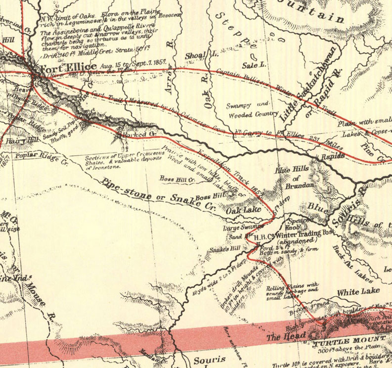 Palliser Map http://www.flickr.com/photos/manitobamaps/2211818555/ A Section of a General Map of the Routes in British North America Explored by the Expedition Under Captain Palliser (1865) The final map in Palliser’s Report is one of the most visually attractive and most significant maps ever published of the area From Lake Superior to the Pacific Ocean. Material from it was often incorporated in other maps in future years. A very clearly conceived map, it is carefully organized, coping gracefully and seemingly effortlessly with a tremendous amount of information. Perhaps a considerable part of the credit for this map should go to Stanford’s Geographical Establishment, which produce it. The map shows the gross natural patterns of the interior extraordinarily effectively. The three prairie steppes, and the great vegetation, climatic, and land capability divisions, including the Fertile Belt for which Palliser is so famous, are all clearly delineated. Many of the major relief features are exaggerated. Geologic features are usually mentioned in descriptive annotations printed on the body of the map, and there are also interpretive remarks such as the reference to the Ancient Lake bottom in the Red River Plain. Some cultural features are shown, the population of Fort Garry is given, and there are very many Place names. There are errors of location, amounting to over 10 miles in some instances, but by and large the main features are accurately enough related to one another so that one is not bothered by these mistakes. The map does tie together a tremendous amount of material on the West in an appealing format. It is truly a masterful example of the cartographer’s craft. (Warkentin and Ruggles. Historical Atlas of Manitoba. map 93, p. 224) ---------------- A General Map of the Routes in British North America Explored by the Expedition under Captain Palliser, During the Years 1857, 1858, 1859, 1860. Compiled from the Observations and Reports of Captain Palliser and his Officers, including the Maps constructed by Dr. Hector, and other authentic documents. 1865. Scale 1 inch to 14.5 miles. Routes are in red. Produced by Stanford’s Geographical Estab. London. The map was issued with the index to Captain Palliser’s Reports. Printed in Great Britain, Parliamentary Papers. Index and Maps to Captain Palliser’s Reports, Showing The Date of Each Journey, the Route, and the Page in which it is described in the Copies of the Reports laid before Parliament on the 19th May 1863. Presented to both Houses of Parliament by Command of Her Majesty. 1865. London: Printed by G.E. Eyre and W. Spottiswoode, 1865. Back to INDEX S4. Manitoba Map 1876 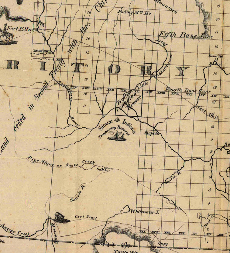 Manitoba Map 1876 http://www.flickr.com/photos/manitobamaps/2115600381/ Map of the Province of Manitoba and Part of the District of Kewatin and North West Territory (1876) Books on the prairies written during the settlement era were generally accompanied by maps of indifferent quality. This is a characteristic map, intended to provide the general reader with the information he requires for following the material in the book. It is gay and pleasant, and drawn in rather carefree fashion. The cartographer, for example, shows off his dexterity in printing in the very long title. This map has glaring errors, such as the indication of a main C. P. R. line west of Selkirk, which was never built, and a steamboat on Lake Manitoba, before one was in use. Also the north-south railroad line was not completed by 1876. Stock engraving blocks were probably used to show Mennonites, Indians, steamboats, and sailing vessels. The map shows the names of some of the townships east of Winnipeg, Millbrook, Plympton and Sunnyside, intended to be minor administrative units on the model of Ontarian townships. It also correctly indicates the two Mennonite reserves. The French Canadian reserve near Emerson never existed. The map shows how settlement was gradually starting to fan out from Winnipeg in the early 1870s, but before there was really much thrust. The famous Palestine area (present Gladstone) and Beautiful Plain (Arden) are marked, but even the favoured Pembina Mountain area had hardly been touched by farmers, except for the Boyne Settlement. On this map we can see how the earliest boundaries of the Province do not conform to the section survey. (Warkentin and Ruggles. Historical Atlas of Manitoba. map 121, p. 276) -------------- Map of the Province of Manitoba and Part of the District of Kewatin and North West Territory Showing the Townships and Settlements. Drawn from the latest Gov. Maps, Surveys and Reports for "The Prairie Province" 1876. Hamilton, J. C. Image Courtesy of University of Manitoba : Archives & Special Collections Back to INDEX S5. Settlement 1870  Settlement in Manitoba 1870-1921 http://www.flickr.com/photos/manitobamaps/2129548738/ Weir, Thomas R. [Settlement 1870-1921] [map]. 1:3,041,280. In: Thomas R. Weir. Economic Atlas of Manitoba. Winnipeg: Manitoba Dept. of Industry and Commerce, 1960, pate 13. These maps show the growth of population during the great settlement period of the late 19th and early 20th centuries. From 1870 to 1901 the population of Manitoba increased from 12,288 to 255,211. The influence of the rivers was still evident in 1870, but by 1881 farmers had leapfrogged the wet and sandy areas, were above the Escarpment and also moving up the Riding Mountain slope, and Icelanders were occupying the western shore of Lake Winnipeg. By 1891 the most favourable areas were settled, except for the Dauphin and Swan river areas which were only beginning to be taken up shortly before 1901. The fringe of agricultural settlement was being reached by that time, though in the next few decades settlers continued to move into the marginal lands of eastern and Interlake Manitoba. The maps also show clearly the expansion of the transportation facilities, particularly the development of the railroad network. (Warkentin and Ruggles. Historical Atlas of Manitoba. map 153, p. 332) Back to INDEX S6. Settlement 1881  Settlement in Manitoba 1870-1921 http://www.flickr.com/photos/manitobamaps/2129548738/ Weir, Thomas R. [Settlement 1870-1921] [map]. 1:3,041,280. In: Thomas R. Weir. Economic Atlas of Manitoba. Winnipeg: Manitoba Dept. of Industry and Commerce, 1960, pate 13. These maps show the growth of population during the great settlement period of the late 19th and early 20th centuries. From 1870 to 1901 the population of Manitoba increased from 12,288 to 255,211. The influence of the rivers was still evident in 1870, but by 1881 farmers had leapfrogged the wet and sandy areas, were above the Escarpment and also moving up the Riding Mountain slope, and Icelanders were occupying the western shore of Lake Winnipeg. By 1891 the most favourable areas were settled, except for the Dauphin and Swan river areas which were only beginning to be taken up shortly before 1901. The fringe of agricultural settlement was being reached by that time, though in the next few decades settlers continued to move into the marginal lands of eastern and Interlake Manitoba. The maps also show clearly the expansion of the transportation facilities, particularly the development of the railroad network. (Warkentin and Ruggles. Historical Atlas of Manitoba. map 153, p. 332) Back to INDEX S7. Settlement 1891  Settlement in Manitoba 1870-1921 http://www.flickr.com/photos/manitobamaps/2129548738/ Weir, Thomas R. [Settlement 1870-1921] [map]. 1:3,041,280. In: Thomas R. Weir. Economic Atlas of Manitoba. Winnipeg: Manitoba Dept. of Industry and Commerce, 1960, pate 13. These maps show the growth of population during the great settlement period of the late 19th and early 20th centuries. From 1870 to 1901 the population of Manitoba increased from 12,288 to 255,211. The influence of the rivers was still evident in 1870, but by 1881 farmers had leapfrogged the wet and sandy areas, were above the Escarpment and also moving up the Riding Mountain slope, and Icelanders were occupying the western shore of Lake Winnipeg. By 1891 the most favourable areas were settled, except for the Dauphin and Swan river areas which were only beginning to be taken up shortly before 1901. The fringe of agricultural settlement was being reached by that time, though in the next few decades settlers continued to move into the marginal lands of eastern and Interlake Manitoba. The maps also show clearly the expansion of the transportation facilities, particularly the development of the railroad network. (Warkentin and Ruggles. Historical Atlas of Manitoba. map 153, p. 332) Back to INDEX S8. SW Mb 1880's  SW Mb in the 1880's Scanned from "By Section, Township and Range - Studies in Prairie Settlement, John Tyman, Brandon University 1972. P48 Back to INDEX S9. Pre-Railway Settlement in Manitoba  Pre-Railway Settlement in Manitoba Scanned from "By Section, Township and Range - Studies in Prairie Settlement, John Tyman, Brandon University 1972. P39 Back to INDEX S10. Postal Service, 1882  Postal Service 1882 Back to INDEX S11. Postal Routes 1884  Postal Routes 1884 Scanned from "By Section, Township and Range - Studies in Prairie Settlement, John Tyman, Brandon University 1972. P48 Back to INDEX S12. 1886 C.P.R. Proposed Lines  From a map of CPR Lines, 1886 Back to INDEX S13. Railway & Guide Map of Manitoba (1887)  Railway & Guide Map of Manitoba (1887) http://www.flickr.com/photos/manitobamaps/4139208350/in/photostream/ Brownlee, J. H. Railway & Guide Map of Manitoba [facsimile]. 1:760,320. Winnipeg: Manitoba Department of Agriculture, 1887. As reproduced by, Ottawa: Association of Canadian Map Libraries and Archives, ACMLA Facsimile Map Series #63, 1980. Published by the authority of the Provincial Government. Winnipeg, March 1887, D.H. Harrison, Minister of Agriculture. Compiled by J.H. Brownlee, C.E., D.L.S., in the offices of the Department of Public Works. Map shows Railways (constructed and projected), Railway Stations, Grain Elevators and Warehouses, Schools, Post Offices, Grist Mills, Hudson Bay Co's. Posts, Provincial Lands and Municipal Boundaries. As settlement advanced in Manitoba local administrative units were established, and various kinds of units were tried before a satisfactory system was found. This map of 1887 shows the stage when municipalities were already in existence, but the boundaries of the much larger counties which had been the administrative units from 1880 until 1886 are still on the map. Considering the density of settlement and travel conditions in Manitoba in 1887, the municipality seemed to be a suitable size between a township and a county, for an effective administrative unit. J.H. Brownlee of Brandon compiled at least three maps of the Province, in 1887, 1888, and 1889 which were published by authority of the Provincial government. In 1891, 1893, 1897 and in 1900 maps very similar in format and at the same scale were produced by the provincial government, without the Brownlee name appearing on the map. Most of these later maps were coloured. Over a succession of years these maps effectively illustrate the general development of the Province, because they show railroad lines, schools, post offices, and sometimes grist mills. These are very useful maps for their time, and there are some indications that they had a wide circulation within the Province. (Warkentin and Ruggles. Historical Atlas of Manitoba. map 71, p. 180). Back to INDEX S14. Manitoba 1890  Manitoba 1890 Map of North-West Ontario Manitoba and North-West Districts (1890) Geo. F. Cram. Map of North-West Ontario Manitoba and North-West Districts [map]. 1:2,787,840. Chicago: Geo. F. Cram, 1890. Image Courtesy of University of Manitoba Archives & Special Collections (Morris Block fonds, MSS 207, A.05-43) www.umanitoba.ca/libraries/units/archives/collections/com... Back to INDEX S15, 1893 Provincial Map Showing Counties  1893 Provincial Map Showing Counties http://www.flickr.com/photos/manitobamaps/3260755021/ Map of the Province of Manitoba Showing the Division into Provincial Counties (1893) Dawson, S. E. Map of the Province of Manitoba Showing the Division into Provincial Counties [map]. Scale not given. In: S. E. Dawson. Description of the Province of Manitoba Compiled and Arranged from the Field-notes, Plans and Reports of Dominion Land Surveyors, and Published Reports of the Geological Survey, Canadian Pacific Railway Surveys, and Other Official Reports. Ottawa: 1893. Image Courtesy of University of Manitoba Archives & Special Collections Back to INDEX S16. Manitoba 1897  Manitoba 1897 Map of Manitoba, British Columbia and the NorthWest Territo(ies (1897) http://www.flickr.com/photos/manitobamaps/4114634725/ Matthews-Northrup Co. Map of Manitoba, British Columbia and the NorthWest Territories [map]. 1:2,787,840. Buffalo: Matthews-Northrup Co., 1897. Image Courtesy of University of Manitoba Archives & Special Collections (Morris Block fonds, MSS 207, A.05-43) www.umanitoba.ca/libraries/units/archives/collections/com... Back to INDEX S17. Proposed Routes for Railways  Back to INDEX |