S1.
Hind
1859
http://www.flickr.com/photos/manitobamaps/3808734146/
Map of a Portion of Rupert's Land Surveyed and Examined by the
Assinniboine
& Saskatchewan Exploring Expedition in the Year 1858 [Sheet 3]
(1859)
Hind, Henry Youle. Map of a Portion of Rupert's Land Surveyed and
Examined
by the Assinniboine & Saskatchewan Exploring Expedition in the Year
1858
Under Instructions from the Provincial Secretary Canada [Sheet 3]
[map].
1:443,520. In: Henry Youle Hind. North-West Territory Reports of
Progress
Together with a Preliminary and General Report on the Assiniboine and
Saskatchewan
Exploring Expedition Made Under Instructions from the Provincial
Secretary
Canada. Toronto: John Lovell, 1859.
Henry Y. Hind in charge fo the Expedition. James A. Dickinson, Surveyor
&
Engineer. John Fleming, Assist Surveyor & Draughtsman. Engraved by
Maclear
& Co. Lith. Toronto.
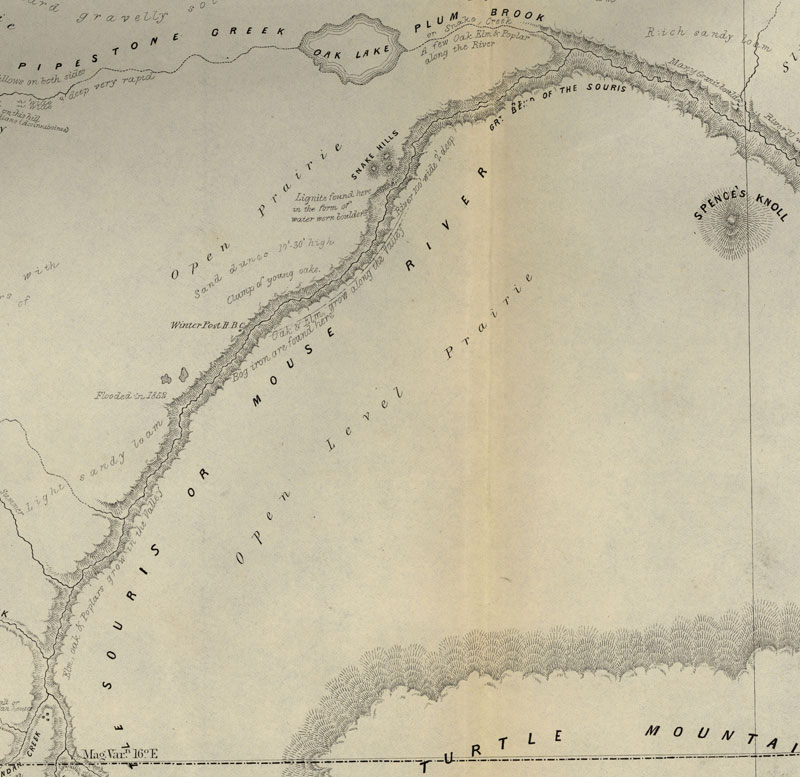
The dotted lines shew those parts not not actually surveyed by the
Expedition,
some being taken from Thompson's Map, such as the East Coast of Lake
Winnipeg
& the Northern portion of Lake Winnipegosis and some information
obtained
in the Country. The continous lines shew those portions of the Country
which
were actually surveyed.
The original maps are on two large sheets and as a result of scanner
size
constraints they have been scanned in four sections with overlap for
display
online.
Both H. Y. Hind and S.J. Dawson prepared vast maps showing the
accomplishments
of their explorations, and one of the most interesting features of
these
maps is the manner in which relief is depicted. Hind used hachures to
show
Riding Mountain, and the technique is very appropriate for that
purpose.
The map also demonstrates how Hind’s observations were centred
around field
mapping, and how comprehensive was the data which he collected.
Vegetation
is mapping, sloughs are indicated in the till plain south of Riding
Mountain,
geological formations are marked, and cart trails are shown on the
ridges
so that one can see that they are used for travel. Soundings are shown
along
the west shore of Lake Winnipeg. Much topographic information is
entered
in the form of written comments and many of the observations, such as
“Vast
Level Prairie adapted for Agriculture”, were reproduced in
countless maps
to follow. The Portage Plains, destined to be one of Canada’s
great agricultural
districts, are designated “Rich Clay Loam”. A special
terminology is occasionally
used, as when the phrase “Oak Orchards” appears.
(Warkentin and Ruggles. Historical Atlas of Manitoba. map 91, p. 220)
Image Courtesy of University of Manitoba Archives & Special
Collections
Manitoba Historical Maps - Flickr
|