Fur Trade Sites
in The R.M. of Cameron

1. McBurney Site
Near present day Menteith, on the north side of the river, such a site
exists on Sec. 18, Tp. 7, Rge. 26. Here have been found musket
balls, trade beads, broken dishware, a rusty knife along with Indian
artifacts. The first homesteaders in this area found no sign of
foundation logs, cellar holes or chimney mounds on this site but this
was to be expected because of the constant shifting of the light sandy
soil. The above artifacts were almost all turned up by
cultivation. This location is sometimes called the McBurney site.
Across the Souris, to the south of this site, it appears that a large
Indian village was located. Sec. 16, Tp. 7, Rge. 22. Human
bones and flint artifacts have been dug up in this area.

2. Magwood Site
In the 1940’s a Hartney resident found a site on sec. 34, Tp. 6,
Rge. 23. It was on the north side of the Souris River. He
believed it to be the remains of a very old trading post. This
one also was probably built by an independent trader. The
location of this post is called the Magwood site.

3.
Alston Site
In 1937 a site was found on Sec. 34, Tp. 6, Rge. 23, about two miles
northeast of Hartney. It was enclosed in an oxbow on the
river. This one was dug into and the log foundations found.
Of the fourteen known trading posts on the river between Souris,
Manitoba and the U.S. border, this is one of two situated on the south
side of the river. There are probably several reasons for posts
built on the north bank, that lookout hills exists on the north side
only may be the best one. This post probably operated in the late
1700’s and is called the Alston site.

4. Fort Mr. Grant
In 1824 Cuthbert Grant also built Fort Grant on the Souris about two
miles south west of Hartney (Sec. 7, Tp. 6. Rge. 23). He was
encouraged in this venture as well by Governor Simpson, who expected
Grant to keep American and independent traders out of the Souris Valley.
Grant’s father, who was of noble birth, worked for the Northwest
Company and had married a Cree woman. Cuthbert was the product of
this union. Grant, like his father, worked for the Northwest
Company but in 1821 became an independent.
Grant operated his Souris Fort as an independent until 1828. At
that time the Hudson Bay Company put him on salary and gave him the
title “Warden of the Plains”. His job was evidently
to ride the Souris Plains of independents and Americans, and to protect
the Fort Garry settlement from the Sioux. Simpson stated it this
way, “As they have a number of Indian and half-breed relations
and are acquainted with the different tribes in that area, they have it
more in their power to harass our opponents than we would with a great
establishment.

5. Fort Ash
Today the Fort Ash site consists of four cellar
holes and two piles of
stone. This fort has not been excavated, although Dana Wright, of
the North Dakota Historical Association, dug up an old musket in
1934. It was a fair sized post, about eighty feet by eighty feet,
but certainly not as large as some of the other forts soon to be built
on the river. It’s clay chinking appears old.
It was undoubtedly abandoned because of Indian attacks. As
Alexander Henry, Jr., records in his diary in 1806, “Fort Ash was
too exposed to attack from the Sioux”.
Fort Ash was obviously a canoe fort. Surrounded by the
river on three sides, there is also a shallow depression on its north
side, so in times of high water it could be approached only by
canoe. To the north of the depression is the Yellow Quill Trail
which parallels the river and can still be seen (very faintly)
today. A few hundred yards north west of the fort and close to
the Yellow Quill Trail is a high sandhill which may have served as a
lookout.

6. The American Fort
In 1934 an old Metis, Antoine Gladu, disclosed the
existence of a
trading post on Sec. 31, Rge. 24, Tp. 5, on the north bank of the
Souris River directly north of Lauder. Gladu was, at this time, a
very old man having been born in the Hartney-Lauder sandhills in
1860. Almost certainly his parents had been buffalo hunters or
worked in the various forts along the river. This old post has
been called the American Fort, and this name handed down through
generations. Even today old timers in the area refer to it as the
American Fort. It was probably built by the American Fur Company,
one of two they built in this area. The other was built near the
junction of the Souris and Antler Rivers.
The American Fort, north of Lauder, was built about 1810. The
site of its chimney mounds indicate that it was in operation for a
considerable length of time so we can speculate that it operated until
1828 when Cuthbert Grant was appointed “Warden of the
Plains” and instructed by the Hudson’s Bay Company to clear
out all opposition trading posts. In the summer of 1828 Grant
reported these two American posts were operating north of the 49th
parallel and it is likely that he put a stop to their operations.
These American posts were also used as a springboard to the rich
Assiniboine and Qu’ Appelle River regions and it is known that
the Americans traded extensively on the Qu’ Appelle.

7. Fort Dejarlais
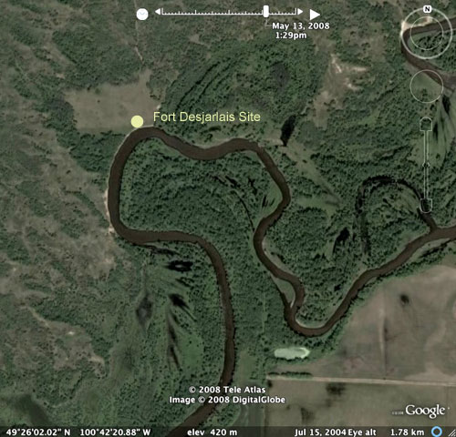
Fort Desjarlais was built in 1836 by Joseph
Desjarlais. It was located
on the north bank of the Souris on Sec. 31, Tp. 5, Rge. 24, to the
north west of Lauder. Downstream about one mile was the location
of the older American Fort.

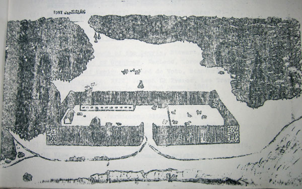
Sketch from "The Souris Plains" by Larry Clarke
The Fort in its heyday featured a sturdy oak palisade surrounding a
long log building and several smaller ones. The site was about
thirty feet above the level of the Souris, which ran past the south
wall. As the site was in the territory frequented by Sioux war parties,
and some five miles from Fort Grant, it was well protected.
The fort was serviced mainly by Red River carts via the Yellow Quill
Trail, running from a point twenty miles from Fort Garry up the
Assiniboine and Souris Rivers. In addition to this, there was the
Hudson’s Bay Trail that ran north through the sand hills from
Fort Desjarlais.


Sources:
Souris River Posts, McMorran, 1948.
The Souris Plains – A History, Larry Clarke
|
|

