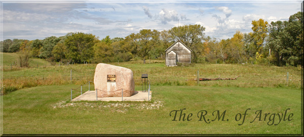
 The
R.M. of Argyle

The
First People
When the first Euro-settlers arrived in Argyle it was obvious to them
that
they
were not the first inhabitants of this land. Aboriginal people often
passed
through
and evidence of past inhabitants was more visible in those days, be it
in
the form of burial mounds or prairie trails. Stone projectile points
found
in the Avery Mound (SW 14-3-13) near the northeastern corner of Rock
Lake,
show that an early culture called The Lake Shore Culture occupied the
territory
about 1500. BC. The discovery of well-made spear points in other area
locations
is evidence that hunters seeking the now long extinct giant bison were
in
the region up to eight or ten thousand years ago. As years passed
more
advanced and cultured people left evidence of well-crafted pottery, and
more
importantly, a clear picture of burial practices in the form of the
readily
identifiable mounds that dot the region. Although settlement by the
Dakota,
Algonquin, Plains Cree and Assiniboine people was intermittent as
befitted
their dependence on the roving herds of bison, it was ongoing and
substantial.
Absence of any written record is of course a challenge as we try to
understand
the times, but thanks to archaeologists, like Argyle’s own Chris
Vickers,
we know the region was then, as it is now... a home.
Place
Names
I’m sure that the region’s lakes and landmarks have carried
various names
given to them over the ages by the inhabitants of the time, but of
course
when our ancestors arrived they often (but not always) had their own
ideas
about names. A 1754 map based upon LaVerendrye’s notes refers to
Rock Lake
as “L. du Brochet” (Pike Lake). Peter Pond on
his 1785 map refers
to it as ”Rib Lake” and the Pembina River as the “Rib
River”. These were
the names in use by native tribes of the time and referred to the whole
Pelican
– Swan Lake system which curved like the flat ribs of a bison.
Today’s name
dates from the correspondence in 1845 of Father George A. Belcourt of
Pembina
in which he describes as the “Lake of the Rocks”, and it
became official
on an 1872 township map by dominion land surveyors.
District History
Anticipating the great boom of the 1880’s a trickle of
adventurous
souls lead the way into this land in the 1870’s. Perhaps the
first were a
small group of Metis from Red River who came to the western end of Rock
Lake
after the Riel resistance and backlash that occurred there against
their
people. They likely knew the area well as the annual buffalo hunts,
only
recently abandoned, took hunters right through the area.
The Rural Municipality of Argyle represents an extensive and diverse
landscape
stretching from Rock Lake northwards through gently rolling terrain
between
Glenora and Baldur, over the patchwork of steep hills and lakes north
of
that town, to the very edges of the sandy prairie south of the
Assiniboine
near the town of Glenboro. There were several routes that
newcomers
might use to get here.
Many followed the well-traveled Pembina or Boundary Commission trail
from
Emerson to near Manitou the pushed westward into new territory. Later
others
followed the Assiniboine westward from Winnipeg, often on overload
flat-bottomed
steamboats, and after unloading near Cypress River or Millford, they
walked
into the northern parts of the region.
The settlement of the region began in earnest with the arrival of John
Wilson
and his family who crossed the Pembina River between Glenora and Pilot
Mound
and homesteaded in the Marringhurst region in 1879. Other settlers,
including
Peter Strang, soon appeared in the Moropano district at the west end of
Rock
Lake, while the Cramers and Playfairs began farming at Otenaw a few
kilometers
northeast of Baldur. The districts of Bru and Grund were founded by
Icelandic
settlers from the recently established colony at Gimli, while William
Craik
was the first to homestead at Dry River between Greenway and Glenora.
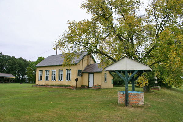 Marringhurst School - a link to
one of the earliest selttements in Argyle.
By 1881 the first council of the newly created R.M. of Argyle was in
place
and by 1886, 15 school districts had been established. Land was being
broken.
Crops were grown.
There were no towns in Argyle as we know them in the 1880’s.
Settlements
were known by the Post Office sometimes accompanied by a general store,
with
perhaps a school or a church nearby contributing to the sense of
identity.
Services such as grist and saw mills opened to serve very local needs
but
were not usually associated with an identifiable village or settlement.
Because
of the relative isolation of the region in the middle ground between
the
Boundary Commission Trail and the Assiniboine they avoided the
speculative
boom towns that blossomed then disappeared along those routes.
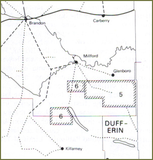 Postal Routes
in the early
1880's
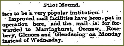
Winnipeg Daily Sun - Dec 3, 1884
As in all parts
of the province in pioneer times the communication and population
patterns evolving in the pre-railroad days were to undergo a big change
once
those rails arrived. In those pre-railway days the recognized
“centers” in
the municipality set about organizing to various degrees. Marringhurst
may
lay claim to being the earliest recognized community. While never even
aspiring
to the status of town or village the newcomers there nevertheless
established
a community whose identity has survived until the present day. A
school,
church, and cemetery were created. Community activities were organized.
The
district is readily identifiable today partly because of the strength
of
those early efforts at community building, and partly because the
actual
towns that sprang up with the rail lines came after Marringhurst was
well
established and weren’t so close as to overshadow that identity.
And of course
the fact that the school and several notable buildings such as the
Marringhurst
Heritage House are still standing has helped.
Contast that with the Otenaw community. It too was an important first
center.
It had a post office early. Its settlers became prominent in the
region.
But when the rails arrived the town of Baldur was just too close to
allow
it to retain the same level of identity. That along with the fact the
no
physical links such as schools, cemeteries or heritage sites remain,
has
rendered Otenaw a somewhat forgotten first settlement.

Glenora
Glenora
followed another pattern. One also repeated throughout the province.
It had an identity and some services, including an important grist ands
sawmill,
and was able to transfer that identity when the rail line located
within
a few miles of the original site. Glenora is the one spot in Argyle
where
there was an attempt to create a speculative town based on hopes and
predictions
that a railway would soon arrive. In the Manitoba Boom of 1881 numerous
such
“cities” were surveyed and promoted as the next big thing.
All were touted
as important railway centers of the future. False claims of services
and
buildings were common. Examples include Manitoba City (Near Manitou)
Manchester
(Near Melita) Souris City (Near Wawanesa) and my favorite - Moberly
which,
contrary to the promotional drawing depicting a steamboat landing, a
town
square, and a lakeside promenade, was actually located on swamp land at
the
west end of Whitewater Lake. With almost no exceptions these towns
never
came into being.
The Glenora claims however were somewhat less extravagant, modest even,
but
ads were placed in Winnipeg papers and lots were sold, and money was
lost.
And it did beat the odds – it became a thriving village that
still exists!
And it thus may claim however to be the first “town” in
Argyle in that there
was a half-hearted effort to promote the original site of Glenora by
the
usual method of selling lots to speculators. The site, unlike the many
other
wonder towns did have both some potential and some actual commercial
activity.
Thomas Rogers was operating a store on SW 20-3-13. The building was a
home
to Edmund Crayston in 1888 and it rests, somewhat the worse for wear
today,
on the Greg Crayston farm about a kilometer from its original site.
Nearby
was a sawmill, first started by Alex Blaine in 1879, then taken over by
Reeves
and Taylor in 1880. (McKitrick) In 1882 Blaine & Reid built a flour
mill.
It was the mill that is credited with providing Glenora with its
name.
It was named after an Ogilvie Co. mill near Montreal that was called
Glenora
Mill and produced “Glenora Patent” flour. Interestingly,
although the ad
in the Winnipeg Sun from September of 1881 has clearly identified the
townsite
of Glenora (without giving the exact location!), at least one pioneer
recalls
that “I never heard any name except “Mill and Store”
for that village”. McKitrick
p79, Named or not it was the the commercial centre of the region for a
short
time and is recalled in several pioneer reminiscences. Alex Rankin from
Killarney
recalls traveling to Glenora “for grists” Wlliam
Cummings recalls that
the first school in the Huntly area was built of lumber hauled from
Glenora.
(Stories of pioneer days at Killarney.) George Lawrence, later an MLA
for
Killarney, operated an agricultural implement business for the Massey
Manufacturing
Company at Glenora in 1883 likely out of his homestead . (Bryce p
646)
Both mills burned in 1885 and it appears that the store may have closed
soon
after, but the name was well enough established to be resurrected when
the
railway finally arrived a few kilometers to the northeast. The
millstone
from that mill has been carefully placed on grounds of St.
George’s Anglican
Church, in that new Glenora.
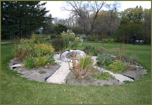 Mill
Stone from the Glenora Mill - no
on
the grounds of St. Georges' Anglican Church in Glenora
In 1892, Chas Graham built another store North of the lake. The
store
has been removed but this became the present day site of Glenora.
During
the same year, the first Glenora School opened and once the Dominion
Grain
Elevator was built, Glenora became a bona fide town.
Another historic point of interest is the Lime Kiln on the Sutton
farm
on Rock Lake.
The area surrounding Glenora is also rich in pre-settlement history.
Chris
Vickers, in his archaeological work in the 1940's found evidence of
nomadic
hunting groups dating back to 1500 B. C. and identified many village
sites
and mounds in the Rock lake vicinity.
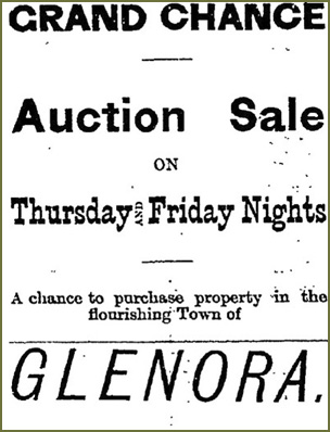 Winnipeg Daily Sun - Sept. 13, 1881
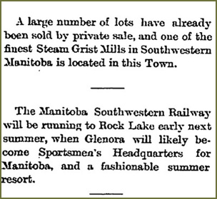 Winnipeg
Daily Sun
- Dec 3, 1884
Elsewhere in Argyle
post offices also put Dry River and Moropano on the map
(literally) and while Dry River did retain its identity for decades
Moropano
was absorbed by the creation of Neelin.
Grund
But the most unique settlement in Argyle, indeed one of the most unique
settlements
in the province would be the Icelandic Settlement in the Grund and Bru
districts.
In the early 1870’s a combination of economic factors and natural
disasters
such as volcanic eruptions prompted increased, and large-scale
emigrations
to North America. On the advice of a Missionary named John Taylor a
large group of
settlers
arrived there on the west side of Lake Winnipeg in the late fall of
1875,
establishing a settlement that has shaped the culture of that part of
Manitoba
through to the present day.
A combination of bad luck and bad weather nearly put an end to that
experiment
as a smallpox epidemic, harsh winters and wet summers made life
extremely
difficult for the first years. The colony persevered and eventually
thrived.
For those that preferred fishing over farming the location served them
well
once they adapted. But it wasn’t great farm land and that likely
prompted
some to try their luck elsewhere.
Everett Parsonage, a pioneer of the Pilot Mound district, had worked
for
John Taylor in Ontario and through him had contacts with some of the
Icelandic
settlers at Gimli. He advised them to visit Argyle. In August of 1880
Sigurdur
Kristofferson and Kristian Jonsson set out to vist Mr. Parsonage and he
showed
them a largely unsettled area in the rolling country in the northern
part
of the Municipality an area we now know as Grund.
As soon as he could Sigurdur filed on SE 10-6-14 an dcalled his new
home
Grund”.
An Icelandic word meaning grassy plain. More soon followed with two
more
men taking homesteads that fall. In the spring of 1881 four families
arrived
at their new homes, by winter there were eight familys, then 17 by the
next
year. By 1884 they had “650 cultivated acres, 60 head of cattle,
62 oxen,
60 sheep, 9 work horses,,,,” and more. Six schools and a church
were built
by 1900. Before Baldur was established a strong community was in place,
and
although the store and post office established at Sigurdur
Kristofferson
home didn’t evolve into a village, the name Grund has lived on.
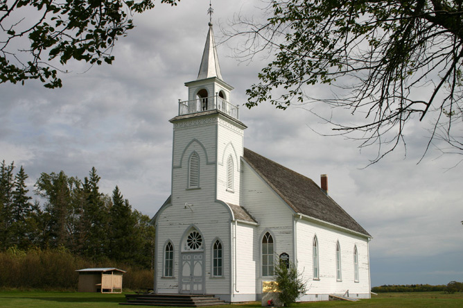 Grund
Church
Baldur
Established – But it was a close call!
In 1890, after several unsuccessful efforts to secure a much-needed
rail
link, the Canadian Northern Pacific Railroad (a branch of the American
company,
completed a line linking Morris with Brandon and passing through the
center
of Argyle. The towns of Baldur and Greenway and Belmont were quickly
established.
But that left quite a stretch without a station and farmers felt they
deserved
better service.
While the surveyors came were busy grading the line farmers in the
Otenaw
district lead by A.W Playfair suceeded in convincing the railway
company
that another station was needed. The first site chosen was three miles
west
of the present town and again citizens including Jesse Chester, Reeve
Peter
Strang and Sigurdur Chistopherson, rallied in support of the current
location.
The surveyor reconsidered and chose a location a few miles further
east.
This still wasn’t what the locals had in mind and Jesse Chester
apparently
carried the surveyor’s equipment himself to the current site. His
persuasion
won out and in the spring of 1890 land was purchased from M.T. Cramer
and
Mr. Taggart for $7.00 per acre.
Given that beginning, the name “Chesterville” suggested by
a railway official
Mr. Lehorn would have seemed appropriate, but Sigurdur
Chistopherson’s daughter
Carrie has been given credit for the suggesting name
“Baldur” the Nordic
God of innocence and summer sun. A vote settled the issue and Baldur it
was.
Carrie herself was recognized in the name of the second avenue of the
new
town.
Before all this was settled Mr. A. E. Cramer had moved his creamery
from
his farm to the site of the new town. It was in turn sold to G.W.
Griffith
as a general store in the spring of 1890, still before the town site
was
settled. The main street was named Elizabeth after Mr. Griffith’s
wife.
In the fall of 1989 Mr. G.W. Playfair had moved his grain buying
business
(which he conducted for Bawlf & Co.) to the new town site in a
building
he also moved from its previous location on his farm. Once the issue of
the
town site was firmly settled he moved the building to the front street
and
began a lumber, furniture and coal business.
Jesse Chester’s house became a sort of unofficial restaurant for
railway
workers and he was soon persuaded to open a boarding house that became
know
as the Chester House.
Other businesses soon followed. Sigurdur Christophers, who had taken
the
role of Icelandic Immigration Officer, opened an office. William
McKnight
build a carriage and blacksmith shop. Thomas E. Poole erected a
store
for his hardware and tinsmith business. A.E. Cramer build a two-storey
building
used as a saddlery shop by C.W. Watson. G.W. Cramer built a blacksmith
shop
which was operated by Harry Goodman.
Thus the names we have come to know as Baldur pioneers established
themselves
in the very early days of the town. By 1898, when Frank Shultz
purchased
the town site from the Northern Pacific Railway, the population was
around
400 and townspeople could choose from four general stores, a hardware,
three
fruit and confectionery stores and a host of other businesses.
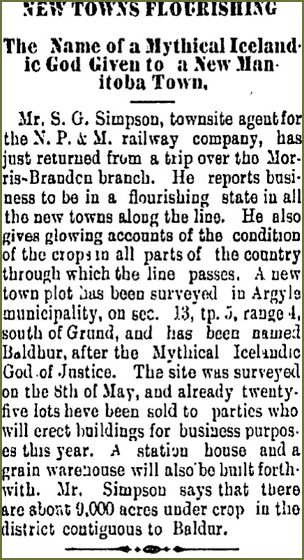 The
Brandon Sun, Jun 5,
1891
The growth of
the town created a population shift that quickly necessitated
a change in the local school districts. The new school district of
Baldur
was carved out of existing districts. As the name “Baldur”
was taken by a
school district in Hnausa, north of Gimli, the name Simpson was chosen
for
the district and the new two-story frame school that was soon erected.
Simpson
was the name of the surveyor who obtained the school site from the
Northern
Pacific. The first classes were held in 1891 in the upper room of the
building
where C.W. Watson operated a saddlery shop with Miss Jeannie Wells as
the
teacher. When the building was completed in 1892 the upper floor was
used
as a lodge room and public hall but as population grew additional
classrooms
and two new teachers were required. By 1905 a new school, a much larger
brick-clad
building was needed. The old one was sold and moved to first street. In
1915
the trustees of Baldur School district at Hnausa were convinced by
Department
of Education official to relinquish the name “Baldur”
allowing for its use
in Argyle’s leading town.
As with schools, churches and congregations had been established
throughout
Argyle with notable buildings at Grund and Marringhurst. The formation
of
towns and the population shifts involved caused a flurry of church
building.
In Baldur Methodist, Presbyterian, Anglican and Lutheran Churches were
built
between 1898 and 1907. All but the Presbyterian are still in use!
Business Growth
Baldur’s first elevator, the Manitoba Elevator, was a
horse-powered structure
built in 1891 by W.O. Fowler and operated by his son Alex. This was
soon
replaced by the Farmer’s Elevator with a 12 horsepower engine.
Other elevators
followed. Today the Baldur Pool Elevator, built in 1927 by the Canadian
Elevator
Co. for the newly formed Pool, remains.
In 1893 W.O. Fowler built the first two-storey brick building on
Elizabeth
Avenue in Baldur. Over the years this building, demolished in
1981,
served as a post office, a bicycle shop, an IOOF Hall and a pool room
and
barber shop.
The oldest building on Elizabeth Avenue in 2010 is the Fowler Block
built
by Alex Fowler and it is still in use as retail outlet. Originally Mr.
Fowler
operated his harness, saddlery and shoe business from the eastern
segment
and the west side was rented to by J. Smith and Sons for a grocery. In
1902
R. Rollin took over the J. Smith business. After a long run it was
taken
over by Karl and Lily Bjarnason (1938-60) then Marcel Fransoo operated
it
until the current owners, Joy and Earl Johnson purchased it. It is a
municipally
designated heritage site.
Percy F. Curtis bought out the business of George Griffith on the
corner
of Elizabeth ab Second Street about 1895. It had been the first store
in
town. In 1901 he completed a new brick two-storey building with a
distinctive
corner entrance and a second level balcony. The new building would
stand
until 1957 a prominent fixture on the corner location. Over the years
it
has been known as The Playfair Brothers, the Neil McDonald Store,
Frederickson’s
Cash Store and more recently it was operated by W.G. Kilgour and the
Co-op.
The upper level was called the Victoria Hall after Queen Victoria. It
was
home to various public gatherings and entertainments, including movies
in
its later years.
Baldur’s first drug store opened in 1894 under the supervision of
Dr. Irving
M. Kleghorn. In 1900 he purchased the building vacated by J. Smith
&
Co, (they moved to the new Fowler Block). His son Raymond took over in
1930
and the building was Cleghorn’s Drug Store until it burned
in 1963.
Thomas E. Poole moved to Baldur in 1890 and established himself as a
hardware
dealer and tinsmith. In 1901 he built the brick building that in 2010
houses
the Argyle Museum.
This designated municipal heritage site has been the site of Hardware
business
operated by Hunter and Gemmill, Hunter and Sons, Wm. Burton (as a
Mashall
Wells Store), and Joe Januska. The interior retains some of the
original
metal ceiling and elements of trim and wall coverings.
Baldur’s first bank was privately owned by Frank Schultz and
opened in 1893.
In 1897 he built the building that served Baldur until it was replaced
in
1977. It became a Union Bank (operated by Mr. Schultz) in 1903 and in
1925
the Royal Bank absorbed the Union Bank.
Mr. Lee Foon, who purchased a restaurant business from Charlie King in
1916,
built a new building in 1924 which houses his store and café and
ice-cream
shop. It remained in the family until 2010.

Dry River
Dry River has to be my favorite place name from the Argyle district.
I’ve
been intrigued about it since hearing my Grandfather Young speak of it
when
I was quite young. Perhaps its just a perfect “prairie”
name, or perhaps
because there were no rivers that I knew of in the vicinity of our
farm,
I wasn’t surprised that the first one I did hear about was dry!
To identify the place I can do no better than to introduce you to May
Graham
and let her explain:
“Dry River district is about 10 miles north-west of Pilot Mound
as the crow
flies and approximately 4 miles south-west of Mariapolls. It is bounded
on
the east by the Pembina River. The Pembina River derives its name from
an
Indian name - Pembina meaning "native cranberry". The old school
district
ran as far north as Township 4 for a short distance and at it's
beginning
it stretched west to the west side of rhe township On the south it goes
as
far south as the township for a part of the way. Then it reaches the
Pembina
River which it follows. Later on in 1907 when Zephyr school district
was
organized, some land. was taken away from the west side of the district.
This district was not settled quite as early as the land to the south
and
east of it owing to the fact that the Pembina River had to be crossed.
At
one point there was a ford in the river and at a place north of the
ford
the Diedrick Bridge was built. The name Diedrick was the name of a man
who
lived in the valley not far from the bridge. It is now known officially
as
the Creamery Bridge. In 1885, the Fairplay Creamery was built and the
Creamery
Bridge was erected. This gave the residents of Dry River two crossings
over
the Pembina River. A man by the name of S.A.Johansen came from Denmark
to
run this creamery. He also helped to build it.”
The first settlers came via Emerson along the Boundary Commission
Trail.
In 1882, the Canadian Pacific Railway came as far as Manitou, and in
1885
it was extended to Pilot Mound, shortening the journey considerably.
Mrs. Graham offers an explanation for the unusual name.
“west of the road which is now known as Highway No. 440, there is
a divide.
Ash Creek runs down from the north and runs west while the Dry River
comes
from the south and runs east to Swan Lake. There is a piece of land
between
the two creeks which is a little higher than that surrounding it. This
is
where the Indians used to cross and J. Flannagan Sr. named it the Pass.
Not
only the Indians used this as a pass, but when buffalo roamed this
district,
they used it also.”
Pioneers included Alex McQuarrie and Tom Frey who came from Ontario in
the
year 1881, followed in the spring of 1882, William Robinson and his
brother-in-law
George Stewart. Mrs. Grahgam tells us that arrivals from 1882 to
1885
included Archie McAuley, William Apperley, W. Wardman, I.
Bentley,
W. Davis, Ike Tealing, A. Bonnan. J. Flanagan, Joe Sauders, W.
Cressard,
John Elson. T. A. Andersen, James and William Baird, Jack Baird, W.
Tisdale
and William Craik.
Dry River School District No. 339 was organized in 1885. The post
office
was opened in 1884 in the home of George Stewart, then moved to
Eason's,
Craik in 1904, followed by S. Robinson who had it until his death in
1948
when it was closed. The first religious services were held in the
school
by Rev. H. Cain Presbyterian minister. Church was held in the school
for
many years and also Sunday School.
Greenway
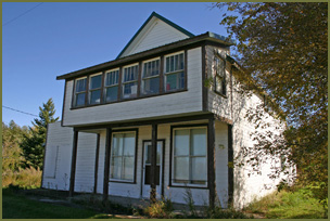
I seems that subsequent events may have proved that the Baldur
“Boosters”
of 1889 were right in holding out for a rail station and the town that
would
follow. The site prospered and expanded. Had the Northern Pacific
Railway
had its way Greenway would have been its only stop as it passed
westward
through Argyle (Belmont was in Argyle at the time but that was soon to
change).
Named after no less a person than the Premier himself who had pioneered
in
the Crystal City area to the south, it would logically have been an
important
commercial centre. The creation of Baldur, followed by a change in
boundaries
which placed the upstart village it in the centre of the revised and
growing
municipality, meant that Greenway would never grow beyond its small
hamlet
status. The towns were just too close together.
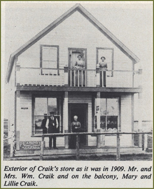
Even so, Greenway, as the focal point of a vibrant and energetic
community,
had an important role to play in Argyle. Before its appearance locals
would
have got their mail at the W. Craik residence, the address
being
Dry River. If you lived in the eastern part of that district you might
go
to Mariapolis for mail and supplies. But as of 1889 the railway company
had
determined that Greenway was the place.
The town site may never have grown beyond the 3-street – three
avenue grid
that was originally surveyed, but it quickly developed the basic
commercial,
educational, recreational and spiritual facilities that would carry it
through
most of a century. For a short time its inhabitants might have hoped
for
more, especially around 1903 when a the Wakopa Subdivision which
created
the new towns of Glenora and Neelin made Greenway somewhat of a
transportation
hub. But there was just no need for more people or more services and
Greenway
remained on of those tiny villages whose importance and far outstripped
its
modest size.
Neelin
Neelin, the town, didn’t make an appearance until the Canadian
Northern built
the Wakopa Line – which left the main line at Greenway and
angled southwest
toward Wakopa, an early settlement south of Boissevain. The route
veered
sharply southward for the first few miles, recognizing the need to
serve
the growing district of Glenora (it didn’t hurt that MLA George
Lawrence’s
family had extensive holdings there) and then skirted the north shore
of
Rock Lake in search of a suitable place to cross the deep valley
between
Rock Lake and Lake Louise. It found such a place on 19-3-14 a site that
Joseph
Neelin had recently purchased and a town was born.
The community though had been there quite a while. Mr. Neelin had
settled
just east of the future town site in 1881. John Cumming, former soldier
and
ship’s captain, who first came to the Marringhurst area in 1879
had moved
to the Huntly area northwest of Neelin in 1882. The region was
soon
served by the Moropano Post Office. In 1887 Roseberry School was
established
on SW 33-3-14. Before long, however, both the school and the post
office
were located in the new town while the building of commercial,
residential
and community building was underway.
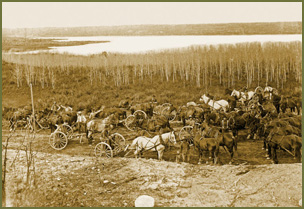 Grading
the line near
Neelin (James Wall Collection - McKee Archives)
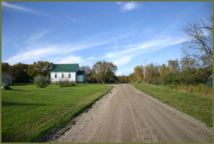 A "street" in Neelin
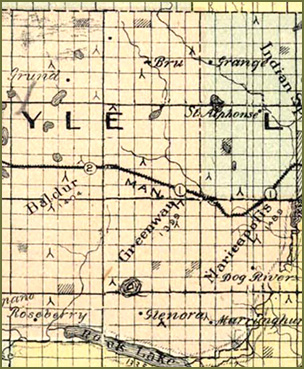 The
region about 1900
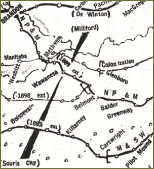 Regional
Rail Lines in
1900

Bibliography
Gleanings of the Past, The Glenora
Community
Boosters History Book Committee
Peel 6387: McKitrick, Thomas George (1873-1952) (compiler) [info].
Corner
stones of empire: The settlement of Crystal City and district in the
Rock
Lake country. Crystal City, Man.: Courier Publishing Co, 1940?. .
Copied Pages relating to Glenora P28&29
Peel 5350: Killarney Women's Institute (compiler) . Stories of pioneer
days
at Killarney. Killarney, Man.: Women's Institute of Killarney, [1929]. .
Peel 5010: Andrew Stewart of the prairie homesteads
Author: McKitrick, Thomas George. Language: English
Altona, Man.: D.W. Friesen & Sons, 1951
Peel 2915: Bryce, George (1844-1931) [info]. A history of Manitoba: Its
resources
and people. Toronto & Montreal: Canada History Co, 1906. .
|