9. The Story
of
John Gregory's Mill
When I was six years old, my family
moved
from
our modest, but comfortable, Winnipeg home to a farm near Baldur. A
young
person making that move today would of course notice quite a
change in the lifestyle, but over the decades there had been a great
levelling in terms of the relative comforts and hardships that
separate rural and urban life. Our farm home in 1955 did not have
plumbing. Water was fetched from a well, hand-pumped and carried in
pails. The outdoor facilities, shall we call them, were a hundred
metres from the back door, and, yes, at times an Eaton's catologue did
rest on the seat.
But six is a good age for making such a move. It was a bit like a
camping trip, an adventure, and I was young enough not to be bothered
by the lack of amenities and old enough to be curious about some of the
changes.
I remember being quite interested in the whole process behind the
creation of butter. In fact it was quite a lesson, because my mom made
butter, not with a traditional churn - which I was to learn about
later,
but
with that modern convenience we'd brought from our urban home - a
Mix-Master! The fact that a wood-burning stove was our new oven was
also a lesson. Our electric stove sat unused because, although
electricity had recently come to the farms (late 1940's), the 220
volt
service required for large appliances wasn't installed. And if learning
where butter came from was memorable, learning where beef came from was
a bit of a revelation. I must say we took it well when our favorite
calf of one year became hamburger the next, and after watching the
rather unpleasant early parts of the process, we quite cheerfully
helped out with the packaging, using a grease pencil to mark the
wrapped cuts with what we considered witty and brave notations such as
"Dicky's Rump Roast".
It was an education. One lesson I found especially interesting was
learning about flour. It happened when Dad announced that he was taking
a load of wheat to Holmfield to get flour. He explained the
process, and indeed it made quite a bit of sense. Why buy it at the
store when you had the raw materials right here?
Of course all these experiences were with me when, many decades later,
I began my explorations into Manitoba's history. I learned that the
Flour Mill at Holmfield had a long history
and is/was an important part of the region's heritage. I learned that
flour mills were a logical necessary and important part of the
settlement experience. And I learned about an earlier mill in the same
region, the traces of which are almost gone, but which have their story
to tell.
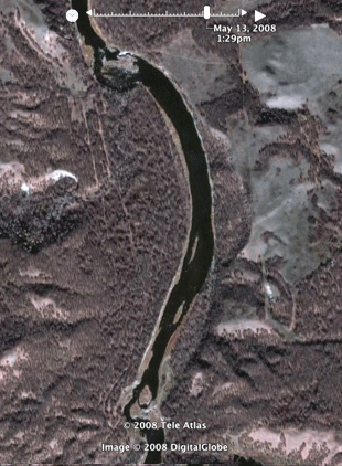 |
Try this.
Go to Google Earth and enter the
coordinates 49' 31'12.70 N and
99'49'34.35W.
With a bit of zooming you should find a
view similiar to this one.
What we are seeing is a stretch of the
Souris River about 10 km south
south west of Wawanesa. Fortunately its one of those sections that are
portrayed at a fairly high resolution.
Even a curious and observant
person might not notice the pair of
lines running north-south to the west of the river channel. A person
who did notice them might at first suppose that they were some sort of
trail, but they don't seem to be going anywhere, at least the one on
the right doesn't seem to go anywhere. And would there be two
parallel trails?
I'm happy to report that they aren't
landing strips for alien
spaceships or even ancient aboriginal linear mounds. They're much more
recent. In fact they date from about 1890 and they represent the hopes
and dreams of one of the area pioneers.
But we're getting ahead of ourselves...
|
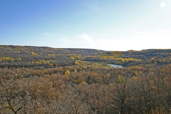
The Evolution of a River Valley
Theoretically
you can stand on one end of the eighty-kilometer wide
Souris Plains and see to the other. In reality, a few wooded areas, a
few dusty towns, and the slight curvature of the earth get in your
way. If viewed from its boundaries however, say the upper reaches
of the Brandon Hills to the north or the Turtle Mountains to the south,
it is indeed quite an unbroken expanse. Where you to look
closely, you might notice, cutting through these plains, in most places
hidden until you are almost upon it, the surprisingly deep and wide
Souris River valley.
The story of this particular river valley begins about 6000 years ago
as the land in the southern prairies was coming out of the most recent
(not perhaps the last) ice age. As the glacier receded, melting
on its way, the waters gathered, waited, and then followed the ice.
They gouged deep trenches into the gravel and shale as they fell
northwards. In a particular stretch of southern Manitoba, one such
stream led into the province near the southwest corner and proceeded
northeast towards present day Souris. It then took a right angle turn
and charged southeast, then east, before emptying into what was to
become the Red River. Their combined waters then flowed northwards into
the retreating sea.
As the ice disappeared, the thick shell of the earth, feeling the
effect of a much-lightened load, began to rise. That threatened
to block the path of the water, but it responded by digging its
trench-like pathway deeper. This went on for some time (a short time in
geological terms, and eternity in human terms) and the trench widened
and sank ever so slowly downwards into the earth’s outer crust. A
gorge was created, with steep walls - here lined with gravel, there
with sand as it cut through an old delta, and further on, with shale
walls as it moved through an ancient sea bed. Its appearance was not
unlike those gullies one sees after a flash flood, a slash through the
ground, barren and bare.
Then, as now, a river tends to grow weary of its course and take every
opportunity to strike a new one. They erode the outer banks until
a new path of least resistance opens and the water follows. But
in this case more powerful forces were at play. The speed of the
earth’s rebounding crust finally overtook the stream’s
effort to entrench itself and it found its path blocked, or rather, it
found an alternate route. It was “captured” by a
northward bound tributary of the Assiniboine, and abandoned it’s
ancient spillway at a point called the Souris Bend or the Souris Elbow
of Capture, just north of present day Margaret.
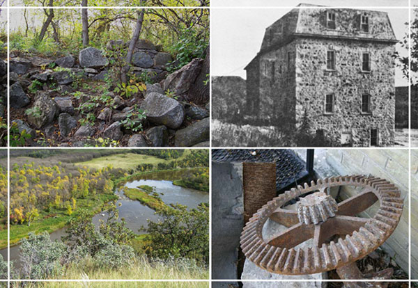
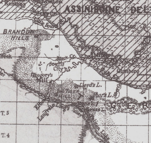
The
Souris Bend area.
It
continued its trenching in that direction, and the earth’s crust
kept rising until gradually both processes slowed down. The excess of
melt water which had created these super rivers was finally all drained
away, leaving great gullies with only a relative trickle, wandering
almost hidden in their oversized containers, to remind them of their
turbulent past. And the river valleys entered the next stage of
their development.
The steep, newly-etched valley walls began to crumble. In places where
the material was softer in nature - sand or gravel - they quickly (in
the geological sense) lost their jagged edges and became rounded and
gentle in appearance. The valley walls through much of the path from
the Manitoba border to Souris are gently sloped, with the river channel
wandering from side to side, occasionally cutting a steep slice out of
one side or the other. But as the channel turns southeast the
earth’s outer layer appears to be made of sterner stuff and the
river has been forced to cut more deeply into it as it descends towards
the lower elevation of the Assiniboine Valley. As the water makes
it’s way downward at an increased rate, it rebounds from one side
of the valley wall to the other and has cut sheer cliffs as it makes
its turns.
The effects of the river’s action have produced their most
dramatic results in the stretch after the river has made its abrupt
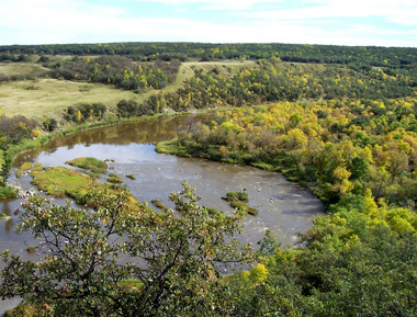
change of course at what we now call the Souris Bend. From the bend on
to Wawanesa, the river valley is at its most rugged. Steep
cliffs overlook the river bends and quick drops in elevation produce
rapids at regular intervals. There are places here that defy the
stereotype of the “prairie landscape”.
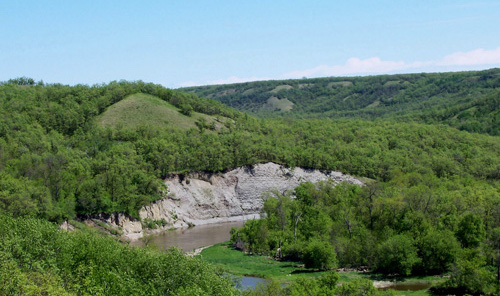
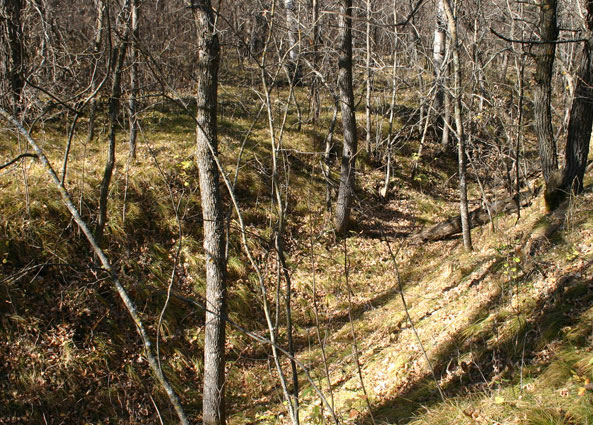
Wild country, just upstream from the mill
site.
And yet when the first European settlers began to arrive around 1880,
they too were drawn to the riverside. One of the first
agricultural settlements in the area was Langvale along the east side
of the river just downstream from the “Bend”.
Water and wood
meant comfort and convenience, and the river valley held the only ready
supply of both. The prairie uplands were generally stripped of
vegetation regularly by fire and trees only took hold near water.
These days living on a river bank can be quite an inconvenience.
Bridges are expensive and none span the Souris between McKellar’s
Bridge near Margaret and the bridge over Highway #2 at Wawanesa. If you
live on one side, it’s quite a drive to visit your neighbor who
lives just across the valley. The pioneers knew the shallow spots and,
except in the high water months of April and May, could cross at will.
You don’t want to try it with a pickup truck though, even with
four-wheel drive! While the riverside locations provided water and
wood, those that settled in the river valley soon found the flat
uplands were easier to till and provided better crops.
With the arrival of the railways and the automobile, locations that
once were on the beaten track suddenly were distinctly off of it.
The remains of the Gregory Mill, hidden in a tangle of riverside brush
at the northern limit of the Souris Bend Wildlife Management Area tell
the tale of that change brought by the new transportation
realities. It went from being a much sought-after service and a
technological marvel, to being a worthless anachronism in just over a
decade. Today a pile of rubble and a deep ditch remaining at the site
are scarcely recognizable for what they were.
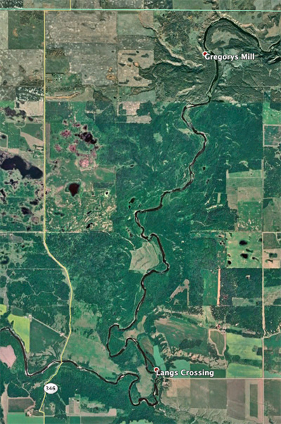
Establishing the Mill
The story of the mill begins in
1882 when John D. Gregory, from
Wingham, Ontario, came to Manitoba and began scouting locations for a
mill site. In 1883 he took title and settled on NW 34-6-18, a farm that
straddled the Souris River about five miles upstream from were it now
passes under Highway #2 near Wawanesa. The site he chose was,
technically, an ideal site for a mill. The river in the Souris
Bend area makes a rather sharp descent (as local rivers go) onto the
Assiniboine Plains allowing for a considerable current. There
were breaks in the valley walls on each side of the river, allowing for
cart trails, and hopefully, a rail crossing. He built a mud dam to back
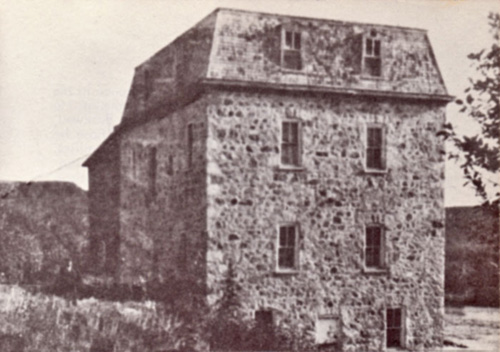
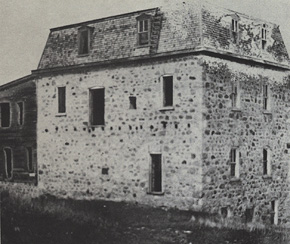
the water up to ensure a steady flow, erected an impressive stone mill
building, set up the necessary equipment and
opened for business. At that time he was 40 km from the rail line but
he hoped that it would come to him, or he saw the business as viable
regardless. The first dam had a head of eight feet of water, and
the mill building was said to have the “most improved
machinery” and a capacity of 75 barrels per day.
In the mid eighties “very liberal local patronage” meant
that the mill was operating day and night. This prompted expansion and
improvements, noteably the addition of a steam engine in 1885. At
that time farmers were coming from a radius of 50 km. [1]
Mr.
Gregory,
like other entrepreneurs who moved to southwestern Manitoba in those
times, was banking on the steady and enduring economic growth of the
area. His idea was right. His location turned out to be
wrong. The beautiful riverside setting was indeed aesthetically
pleasing and convenient in an era when rivers provided transportation,
water, wooded areas, and power for mills. The early settlers were from
Ontario, and they had water-power on the brain. All early settlements.
Souris (Plum Creek) Millford, Old Stockton, were, to an extent, judged
on the availability of water power. But two things happened. First they
soon realized that prairie rivers were very seasonal and thus quite
unreliable
as a source of water power, and second; steam power was quickly
becoming a more reliable, and in the long run, less expensive, option.
And while Mr. Gregory adapted by adding steam power to his
mill, his location was not destined to be a population centre.
The rail lines passed to the north at Wawanesa and to the south at
Boissevain. Transportation quickly shifted from river and cart trail,
to rail and graded roads, and eventually to the automobile.
Mr. Gregory was not alone in selecting a location that was ideal for
one era, just as the world was quickly slipping into the next one.
Hindsight makes re-thinking his decision just a bit too easy. The truth
was that he had every right to expect that a rail line was coming soon
and in the meantime there was a substantial local need for his
services. In fact, the very lack of a railway meant that a new
settlement needed a mill. Wheat was plentiful, imported goods were
expensive. Locally ground flour kept families fed. A survey of pioneer
reminiscences in local histories reveals that a trip to the Gregory
Mill was a memorable event. People came from as far away as the
Boissevain district. The trip would likely involve an overnight
stay at one of the many “Stopping Houses” that provided the
early equivalent of the roadside motel and restaurant. Children
would long remember the first time they got to accompany their father
on such a trip. [3]
A
view from the hiking trail that leads to the mill site.
Newspapers of the mid 1880’s offer us more glimpses of Mr.
Gregory and his mill and help to illustrate their respective places in
the local community and its economy.
By 1882 he was apparently established in Winnipeg and seems to have
been exploring his options. The first mention of him appears in the
Winnipeg Daily times of September 20, 1882, which reports that he had
already bought and sold (at a tidy profit) one farm in the area. The
Winnipeg Daily Sun reports that Mr. Gregory along with two others had
“returned to the city, after a visit to the famous Rock Lake
district in Southern Manitoba. They speak in the highest terms of this
section as an agricultural district.” One can infer that he
was scouting for a suitable location. Another story in November
of 1882 has him reporting on crops in the vicinity of the Elliott
Settlement near where he was to build his mill. The Times reports
refers to him as “an old and experienced miller” and
indicated that he is “personally acquainted with a number of
settlers” in the district.
Mr. Gregory
also
appears in one of those interesting features of early papers: the hotel
guest list! Reports in 1883 indicate that he was staying at the
Brunswick for a time in June and at the Grand Union in September. No
doubt getting a mill set up and running necessitated some
“business travel”. [4]
A Local
Institution
The first mention I
found regarding the mill itself was incidental and
gave no details as to its location, mentioning only that a
missing horse had been “traced as far as Gregory’s mill,
Souris, where it was probably ground up into sausage meat.” Was
that some sort of inside joke? A short notice in paper the following
month offers a bit more information, and includes his operation as part
of the community of Whitehead, a fledgling village centred around a
country store and post office a few kilometres west of the mill site.
Charles Kent was the storekeeper who located “on the track
leading south to the grist mill erected by John Gregory on the Souris
River...” [5]
Winnipeg
Daily Times,
16/04/83
This reporter didn't get
the names correct, but construction started
that summer and the mill was built "up the river'".
An
1884 submission
from that community was prophetic and reflected the
hope of numerous small settlements in the era before rail lines were
plotted out:
“This infant city has not shuffled off this mortal coil, but
promises to be a fine place if only the railroad would come anywhere
near. Mr. Gregory is in Ontario; expected shortly.”
A related article goes on to outline plans for a “picnic and
celebration” at the “mill at Whitehead.” on June 28
featuring “games and amusements of all kinds” and goes on
at length to extol the virtues of the area, the wonderful river valley
views. few days. Another article informs us that, ” The Souris
City people propose celebrating the 28th June instead of the First of
July. They will go to the mill at Whitehead, and enjoy themselves in
true picnic style.” [6]
The location, given as 34/6/18, is the mill’s location, not
that of the actual “town”, so it seems that
the recreation potential the mills attractive riverside location was
already identified. For a short time the “infant city” of
Whitehead was the social centre of the region! [7]
A report from nearby Langvale in 1885 noted that the “flouring
mill of Mr.Gregory” had been shut down due to low water,
but that a “powerful engine” was being installed and that
the mill would be running again in a “few days”. In
June of that same year we note that Riverside Municipality had remitted
Gregory’s taxes. This is something municipalities did as a way of
supporting needed services.
1886 brought
more expansion as a letter to the editor reported that ”the
flouring mill at Whitehead is running full blast night and day”
and that the “energetic proprietor” had just completed an
addition to the facility. He goes on to say, ”All we
want is this part of the country is better railway
facilities.”
Also in 1886, rumours persisted that a rail line might cross the valley
near the mill as Mr. Nichol of nearby Souris City reported that the
railway engineer was coming back to ” try Gregory’s Mill
crossing”.
On a more personal note, we learn that in 1886 Mr. Gregory was a
vestryman of the Rounthwaite Anglican church. [8]
The mill is mentioned often
in the accounts of the Souris City
settlement a few miles downstream, and in reminiscences of pioneers of
the Wawanesa and Riverdale areas. Blanche Miller, writing in the
“Riverdale Heritage” recalls that her father Billie Miller
worked in the mill from 1884 to 1888 with Richard Skuce and George
Durnin. Gregory’s two sons were also employed, making it a fairly
large operation. [9]
The Riverside History also reports that the mill offered the latest in
technology and that:
“Customers had come to Gregory's Mill from all directions, some as far
south as the U.S. border. The flour, of superior quality, milled
by the "Hungarian Patent Process," was drawn to Brandon by mule team
and horse teams, made three trips a week to the flour in a warehouse
until a carload was gathered, to ship east by rail. On the return trip,
they brought back provisions needed at the mill.” [10]
Reports in local histories, based as they are on reminiscence, are
often somewhat contradictory in relating the story of the mill. One
common element however was the reference to its short life span. Most
report that it existed during the 1880’s and that it closed after
the dam was twice destroyed by spring runoff. The general consensus was
that it was no longer operating by 1890. [11]
In this case the local
legends don’t match the facts. Far from being discouraged by
minor setbacks, delays in railway access, and problems with the dam,
Mr. Gregory instead of retreating, pushed forward.
A rare map from the era showing the Gregory
Mill location.
From Warren Upham's 1890 map of the Lake Agassiz: Scanned from The
Historical Atlas of Manitoba
Expansion
& Competition
In
about
1888
he began a considerable expansion. A higher dam was constructed about a
kilometer upstream. The first attempt was cut short when high water
“carried away a piece of the west bank" but the work was
completed and certainly must have been the foremost feat of engineering
in rural Westman at the time. A report in the Brandon Sun described it
thus:
“The dam, is 600 feet long, 160 feet
wide at
its base and 29 feet
at the top, is 30 feet high from the bed of the river, and is composed
entirely of trees, brush, boulders gravel and earth, intermixed,
forming an impenetrable mass, capable of resisting almost any pressure.
Behind the dam there is now a body of water with a head of 28 feet,
covering 5000 acres, and extending for 6 miles to the south. The race
is 4000 feet long and from 6 to 18 feet; much of the material taken
from this was used on the dam.” [12]
There was a moderately sharp bend across which he could construct a
“mill race” or channel to direct the flow to the mill. That
mill race is still visible today and must be seen to be
appreciated. Time has erased almost all other traces of the
operation, and a river traveler will pass the site by unless he knows
what he is looking for. One
has to marvel at the engineering, and just sheer work, that must have
been required to build it the mill race. What equipment would
they have to
move that amount of earth? Where would they get such equipment -
before the municipalities had even begun to plan the grid of gravel
roads that were to appear with the advent of the automobile? Some
stretches are gouged out of the hillside, while in other places the
sides are built up like dikes. The whole enterprise must have involved
a substantial effort - in time and money.
120 years after it was
abandonned -
the
mill race is quite visible today, from the hiking trail to the mill,
and from Google Earth!
The cost was 15000 dollars, an amazing amount of money for a local
enterprise, but Mr. Gregory projected that he now had enough water
backed up to allow for 3 month of operation during times of low water
flow, and could boost his capacity to 125 barrel per day in the
winter. [13]
All this expansion despite bad news on the railway front!
The End of an Era
By 1889 we had, not one, but two railways about to cross the
district. One was angling up from Morris to Brandon, and destined
to cross the Souris River at Wawanesa while the existing line from
Winnipeg to Glenboro was finally to be extended to Souris. A newspaper
report noted that Gregory Mill and a mill at Souris City served the
local area but that, “before another crop is marketed things will
be changed” and that the new Northwest Pacific and Manitoba
Railway line the Municipality would have “unsurpassed railway
facilities. [14]
The region
had two rail lines by 1891. The siding at Elliott's was the closest
railway link for Mr. Gregory's flour, about eight kilometres away.
The
railway came
as
close as eight kilometers and Mr. Gregory was soon exporting flour. The
Brandon Sun reports that in June of 1890 he shipped 2 cars of flour
from Elliott Siding. [15]
Perhaps Mr. Gregory, who instead
of retrenching, had expanded his
operations, was going to remain viable. The mill was obviously thriving
in 1891 when we see a report from Belmont where they were
“agitating for a good grist mill” noting that “almost
every day” teams passed through on their way to
Gregory’s which was 40 kilometres away. [16] Despite the
fact that a closer rail line would have provided better access to
export markets, the mill was providing a valuable service to locals who
continued to patronize it.
In 1892 a notice by the Oakland
council appeared in the Sun advising
that there would be a vote on a bylaw to “grant a bonus of $1000
to John Gregory’s mill”. Having a nearby mill was so
important that incentives were often provided by towns or
municipalities. [17]
The article notes that:
“Mr. Gregory intends increasing
capacity to…250 barrel
during the next year if he succeeds in getting better shipping
facilities. At present he is five miles from the nearest railway
station, but he is confident that he will be able to overcome that
difficulty before long.” [18]
He still hadn’t given up! Perhaps
a spur line wasn’t out of
the question?
Well that “difficulty” never was
overcome. The site of the
Gregory Mill, today, as it was then, is still eight kilometres from a
rail line.
As it
turned
out it
likely wasn’t the lack of access to the export market that sealed
the fate of Gregory’s Mill. It was the establishment of
mills in the new population centres that sprang up along the new
railways that spelled the end.
For example, until Glenboro got its mill in 1994, (also with $3000
bonus), many from that area had patronized Gregory’s Mill.
[19] At Holmfield to the south, a mill was serving the Killarney
and Boissevain district. Wawnesa was exploring the idea of
offering a bonus get one started in that new village.
I could find no notice in the media of the day regarding the closing of
the mill. Reference to it just ceased to appear, in much the same way
that references to the abandoned towns of the settlement era just
disappeared. Instead, what we learn from the newspapers is that mills
were springing up elsewhere. And so was Mr. Gregory.
By 1895 he was applying for a bonus offered by the municipality of
Oakland for the erection of a new mill at Nesbitt, some twelve
kilometres northwest of his old location.
The mill was towards the bottom
right corner of the picture and 10
metres up the bank. I believe that the first dam was here –
likely designed to direct the flow to the right bank.
|
Taken from
the hill
north of the mill (see picture on the left).
Photo from the S.J. McKee Archives, Brandon University.
|
A letter appearing in
the Daily Nor’Wester submitted by George
Fawkes of Nesbitt, dated May 21, 1895 reports that Nesbitt and district
voted on a bylaw that granted a bonus of $3000 towards the erection of
a mill, that John Gregory had applied for said bonus, and that Mr.
Gregory, in response to a question from a councilor said he could be up
and running within ten days of gaining access to the site. No mention
is made of Mr. Gregory’s previous mill but it seems likely is
that this more about moving his operations than starting anew?
Council was also considering a similar deal for a mill at Wawanesa but
some (those from Nesbitt) argued that two mills in the
municipality were not needed. A few weeks later the
Nor’Wester reported that as of May 29 the first machinery was
“brought into town today” The article confirms the earlier
report that John Gregory was the miller in charge and went on to say
that the mill would be operation for this year’s harvest and that
he assured the reporter that the “mill will be first class in
every particular.” [20]
In a
somewhat
contradictory report we see that the Oakland Council meeting report
from June 13, 1895 indicates the Mr. Gregory attended and that his
application was accepted. At the same meeting the council decided to
approve his application. [21] It could be just bad reporting or
it
could be that then. as now, sometimes things proceed ahead of
“official” authorization.
Later that summer he was hospitalized for a problem with his foot,
which eventually led to amputation, but with a favourable prognosis.
[22] On June 21 of the following year he died. [23]
When John Gregory bought his riverside property and started his
operation he must have been a wealthy man. He is said to have
died broke, having lost a hundred thousand dollars. [24]
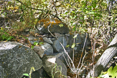
Little is left of the walls.
|
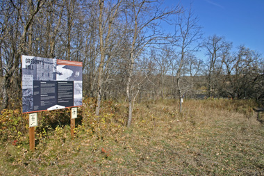
A sign informs
today's visitors.
|
The building was
abandoned and slowly disintegrated.
Rainwater leaked in, destroying the roof and weakening the mortar in
the stone walls and vandals broke the windows and eventually pushed in
the walls. The sight now now difficult to find. Trees have
surrounded what is left of the foundation making it virtually invisible
to a passer-by on the river. One might notice the rocks,
originally from the walls, that have tumbled down the steep bank as far
as the water’s edge. Thanks to the efforts of Arthur Bund
of the Nesbitt area, the large stone that once served as a doorstep for
the mill now rests in the Minnewawa Cemetery near the junction of
Highways Two and Ten. A huge gear from the mill itself is in on
display at the Sipiweski Museum in Wawanesa, and a few other scattered
remnants of the machinery have found their way into private
collections. Who knows what else might lie buried under an
unassuming pile of rubble on a secluded river bank.
Finding the Site.
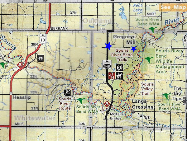
Rd 35N
runs from Rd 346 to near the trail head. Follow the trail down the
valley wall until you find the interpretive sign. The foundations are
hidden in dense bush just below the sign.
Sources
1. Brandon Sun Weekly 10/12/91
2. Riverside Centennial Committee, Riverside Heritage, 1996, 253
3. Riverside Heritage, story by Margaret Bissett P29
4. Material from newspapers:
Winnipeg Daily Times 20/09/82, 08/11/82, 21/09/83
The Winnipeg Daily Sun 30/09/82, 21/06/83
5. Stuart, J.A.D., The Prairie W.A.S.P (A History of the Rural
Municipality
of Oakland Manitoba) Prairie Publishing Company, Winnipeg,
Mb 87
6. Brandon Sun Weekly 12/06/84
7. Riverside Heritage, 1996, 253
8 Brandon Sun Weekly 05/02/85, 01/04/86, 19/08/86, 08/04/86)
9. Riverside Heritage, 1996, 59
10. Riverside Heritage, 1996, 253
11. Riverside Heritage, 1996, 52
12. Brandon Sun Weekly, 10/12/91
13. Brandon Sun Weekly, 10/12/91
14. Brandon Sun Weekly, 13/06/89
15. Brandon Sun Weekly, 12/06/90
16. Brandon Sun Weekly, 05/03/91
17. John Everitt, John & Kempthorne, Roberta, The Flour Milling
Industry
in Manitoba Since 1870, Manitoba History, Number 26, Autumn 1993
… “bonuses” were offered by towns, villages, and
municipalities in order
to attract millers to, or keep them in, their communities. The bonuses
were
designed to increase the overall supply of mills, but they may have
also
affected the distribution, by attracting a miller to one settlement,
and
thus crushing the hopes of a competing neighbour. ….
Between 1882 and 1890
at least two dozen bonus offers were made in Manitoba. In 1890 there
were
22 small mills across the province, nine of which may have resulted
from
the bonusing system
18. Brandon Sun Weekly, 09/06/92
19. Glenboro and Area Historical Society, Beneath the Long Grass,
1979, 123
20 Daily Nor’Wester 23/05/95 & 31/05/95
21. Brandon Sun Weekly, 13/06/95
22. Brandon Sun Weekly, 22/08/95 & 06/09/95
23. Vital Statistics Manitoba, http://vitalstats.gov.mb.ca/Query.php
24. Riverside Heritage, 52
|
|
|