
10: Where is Bunclody? I’m pretty sure that the first time I ever heard of
Bunclody, someone
was making fun of the name. It was Vince Dodds, the morning man on our
local (Brandon) radio station, and he had a running bit involving
checking in on the exploits of the Bunclody Bridge Marching Band.
Something like that, a gentle comment about small town life at a time
when small towns were rapidly disappearing. It's a pleasant name, Irish
in origin, and, yes, perhaps a bit fanciful when compared to the nearby
communities - with their bland, sensible names like Hayfield, Carroll,
or Brandon.
In any case, the name must have impressed me enough to remember it, but not enough to prompt a visit for many years. It wasn’t until decades later while scouting canoe trips on the Souris River that I made my first visit. Bridges are all-important when planning paddling day trips, that's where one finds the most user-friendly access to the river, and I soon became acquainted with all such points in western Manitoba. What a treat it was to finally see the place. Yes, you could see why the radio jokester had singled it out. By the sixties many former prairie villages were that in name only. It was as if we were reluctant to take down the road signs, change the road maps and admit defeat. Bunclody turned out to be just a shady roadside park nestled alongside a gravel road near the river where it brushed against the southern rim of a wide valley. It barely qualified as a ghost town! At first glance only the two cairns in the park, and one residence across from it, gave evidence of any habitation, past or present. It's funny how you can miss things, and odd that in driving through the valley I didn't notice the way the road southward up out of the valley cut through a narrow ridge running along the hillside. Not so odd perhaps that on several trips up the gentle slope northwards from the river, I failed to notice the signs of a substantial embankment approaching the river a kilometres to the east; unmistakable evidence of a railway line. It's obvious if you know what you're looking for, but a quite unobtrusive element of the rolling valley landform if you don't. And its quite understandable that later, as I paddled downstream from Souris to where our vehicle was waiting by the Bunclody Bridge, I failed to notice the same embankment curtailed on either side of the river. The constant erosion of a riverbank over a few decades had erased much of the evidence. 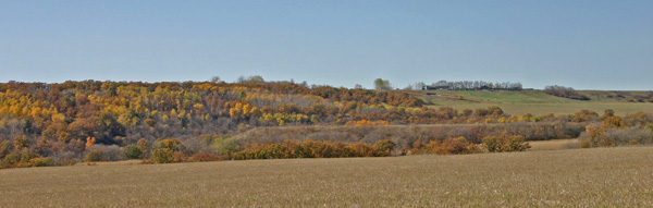 Can you
spot the rail line embankment, along the centre
of this photo?
Today a drive from Minto west to Elgin, or north to Boissevain, essentially through the eastern reaches of the Souris Plains, gives one an understanding of the term "wide open spaces". Then, as now, the traveler new to the area, and on a trek from Boissevain northwards to Brandon, whether on the rutted ox-cart path known as the Heaslip Trail, or on the smoothly paved Highway 10, might be surprised when, out of nowhere, the valley of the Souris River appears, a kilometer wide / 70 metre deep channel cut over ten thousand years ago as the last of the glacial lakes drained. Scenic it may well be, but to the railroad builder it holds no romantic charms. It is an obstacle to be crossed. A challenge perhaps, a nuisance, definitely. When building a railway over hills or through valleys it is often advisable to the travel a few extra kilometers to avoid a steep grade and the expensive construction costs associated with difficult terrain. Trains don't do well on hills, and keeping the grade or slope of the track as gentle as possible is a priority in construction. As far as the prairies go, the northern portion of the Souris River valley is a major challenge. In 1904 and 1905 the Great Northern survey crews were at work surveying a railroad from St. John’s N.D. to Brandon Manitoba. They rejected a crossing straight south of Minto (where Highway#10 runs today) as at that point the valley is both deep and wide. Instead they selected a site a bit upstream where the southern lip of the valley, although steep, brushed right up against the stream, while the gentle slope on the north side could be crossed with a modest embankment. To get there, the line bends westward as it approached the Souris and follows the curve of the river. The elevator and station established on the south side of the river was called Bunclody, a name already in use for a nearby school and Post Office. The community had its beginning when George McGill and James Copeland settled with their families along the banks of the Souris River in 1881, A school was built in 1884 and George McGill, the Secretary-Treasurer was given the privilege of naming the school. He chose the name of the district he left in Ireland. The first church services in the Bunclody district were held in 1883 in the home of Mr. James Copeland and later moved to the school in 1886 and held there until the church was built in 1908. Crossing the river was a necessity, and there were three ferries in operation in the 1880's. The Osborn Ferry near the settlement, the McGill Ferry was three kilometres upstream and Shepherd's Ferry, not far from where Highway #10 crosses river now. In 1893 a pile bridge was built and in 1902 the river was very high and all the bridges from Souris to Wawanesa were taken out with the ice flow in the spring. In 1903 the first span bridge was and that served until 1937. That was Bunclody in 1905, a community, but not a village. It was the decision by the Great Northern Railway, a giant U.S. corporation, to build a line into Canada that put Bunclody on the map. A Big Project The river crossing made Bunclody the major construction site of the whole project. Three work camps were quickly set up, one at the deep ravine three kilometres south of the crossing, one at the town site on the south side of the river where the station house was built, and one on the north side of the river. Each camp had a steam shovel, modern technology not available a mere 25 years earlier when the CPR crossed Manitoba. Dinky engines were used to haul and dump cars as the grade was built up. It was a major engineering project undertaken by one of the largest America railroad. The ravines south of the river were crossed by building temporary trestles and dumping fill to create a road-level earthen dam, complete with huge pipes designed to let the runoff through. The pipes soon broke and had to be replaced with concrete tunnels two metres square - still quite visible today, although somewhat clogged with rubble. One resident told me about boyhood adventures that included a dare to go through the tunnel. The bridge over the Souris was 132 metres long and 26 metres high. Timber for the trestles, including 30 metre long cedar pilings had to be hauled from the CN Rail stop at Carroll, about eight kilometres away. The elevator and station, along with a bunkhouse for some of the many full time employees required to maintain the line, were situated halfway up the southern ridge of the valley, half a kilometer from the bridge. The water tank was on the far side of the river slightly north of the bridge, with pumps and pipes to draw river water for the steam engines. 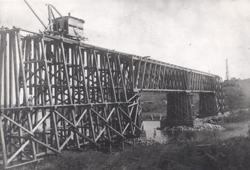 Crossing the Souris at Bunclody 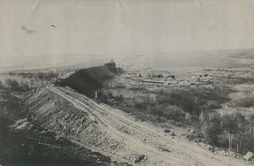 Preparing the grade towards the crossing of the Souris near Bunclody. Today, standing on the old rail line where it abruptly ends atop a steep cliff at the river's edge, having followed it from that site through a pasture as it curved towards the former crossing, one can look northward across the river and see one of the few remaining obvious signs of the old line. Directly below you, in the centre of the river is a small gravel bar, once the base of the central bridge support, and across the river where the valley wall slopes gently away from the water's edge, is the high embankment built to carry the line gently across the wide valley. Bunclody never became a very big village, but it did become a busy place – for a while. From the day that first train came through on June of 1906, there were two passenger trains per day, going south at 8 a.m. and north at 7 p.m., six days a week. The freight train ran every day, south on one day, north the next, except Sunday. 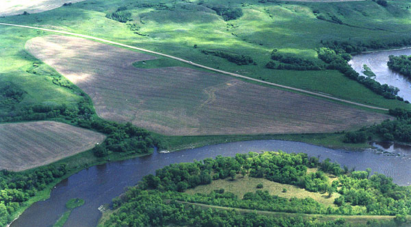 The abandoned rail bed and the foundation of the bridge were readily visible from the air in 2001. If one were to stop at the station and swap railway stories with the locals you'd likely hear about the time in 1916 when a runaway engine from Minto stopped at Bunclody. Later in the day the Engineer and fireman came walking down the track looking for the runaway. It happened when the engineer thought that a switch was closed at Minto and he and fireman jumped ship, so to speak. A closed switch would create a dangerous derailment. It turned out that the switch open. This was not as uncommon an event as one might expect, there was another incident a year or so later when a boxcar got away from the Heaslip siding and rolled on downhill to Bunclody. Or perhaps you'd hear about the morning in 1914 when three horses wandered onto the right-of-way. They were frightened by the approach of the freight train and ran ahead of it to the bridge; where they jumped off and met their deaths on the frozen river 26 metres below. Here, as at other stops on the line, you would certainly hear the winter tales. Snow was the winter enemy. Trains were stuck often in cuts sometimes for a considerable stay! The Bunclody History relates the story of a train stuck in a cut from November until March. That was in the first year of operation and it was a work train, which had its own kitchen so the crew lived there for the winter. It was on the farm of a Mr. Roger, who obliged by hauling them water. The worst spot was the Wilson Cut two kilometres north of
Heaslip, the
site of an adventure in March of 1923. A train with two engines and a
snowplow was stuck and snow drifted in half-way up the windows. In such
cases, neighboring farmers were often called upon to help out and the
presumably patient passengers relied on the kindness of strangers
so-to-speak. Supplies were brought from the Heaslip store and lunch was
served.
Spring runoff also could be a problem when the pipes (culverts) under ravine embankments couldn't handle the water. But other than snowfall, and a few problems with clogged culverts at spring runoff, very few things interrupted the service. Doctors and patients relied on it. It evolved from being a novelty to being a necessity. The End of The Line By late 20's it was apparent that big profits for the company would never materialize. The line had been built into an area that was already served by east-west lines. Unlike the original CPR lines, the owners had been prevented from making large start-up profits from the establishment of towns and the grants of land often associated with a new line. With the defeat of Laurier in 1911, the hope of a reciprocity agreement with the US, which would have increased north-south freight, was effectively over. The population had reached its peak and the car was establishing itself as the mode of choice for personal transportation. This possibility of reciprocity had encouraged the expansion of the Great Northern and some speculated that it would lead to a large portion of the grain harvest being transported through the U.S. Needless to say, there were many Canadians opposed to reciprocity for that very reason. The Portage La Prairie Weekly noted that “The Great Northern Railway…has no less than seventeen different lines operating between Canada and the country over the border…: and could see that much business would go that way. “ 1 That was a pretty good argument against Reciprocity from a western point of view. Another force at play was the growth of the cooperative initiative that became the Manitoba Pool Elevators. "Part of the problem … was that farmers were prepared to support the Manitoba Pool, even at a financial cost to themselves." McCabe had monopoly on the GN line, thus there were no Pool Elevators along its route. At one time Pool was paying 53 per bushel while McCabe as much as 75. By 1929 losses had mounted to $74000. In 1935 grain tonnage on the line was only 16.5 % of what it had been in 1913. 2 At the same time passenger service fell off. Although it was never intended to be the primary source of income, it was helpful to the bottom line. In 1906 travel by auto was slow and unreliable. But people really liked the freedom the car gave them, and better roads along with cheaper, more reliable vehicles developed rapidly. By 1922 a "highway" existed from Brandon to Boissevain and on to the border. By 1927 rail passenger numbers began to decline. The depression worsened the situation and only pressure from the government kept it open until 1936 when the mail contract ended. It was simply no longer a viable enterprise, if it ever was. The tracks torn up in 1937 after there were no offer for the purchase of the line. The company formally continued to exist until Dec. 12. 1963 to allow for ongoing land transfers. The last train ran June 14, 1936. Brandon railway historian Lawrence Stuckey remembered with apparent fondness the day when he and a friend waved to the engineer for the last time. 3 So ended a chapter in the region's transportation history. The line is credited with ending the rural isolation felt by many Westman settlers and offered them an important timesaving travel option. Daytime shopping trips to Brandon were a treat, students at university could get home for weekends. But the car and the improved road conditions offered a new sense of freedom to rural residents, and the line, though remembered fondly by old-timers, was just not needed any longer. So in a way the Bunclody story is the story of not one, but two false starts. Sources 1. Portage La Prairie Weekly July 26, 1911 2. Everitt p84 3.Bain & Stuckey p14 Todd, John, Jim Hill’s Canadian Railway, Canadian Rail No. 283, August 1975, Canadian Railroad Historical Association, Montreal Everitt, John, Kempthorne, Roberta, Scafer, Charles, Controlled Aggression: James J. Hill and the Brandon, Saskatchewan and Hudson’s Bay Railway, Brandon University, 1987, Rose, D.F., Bunclody Community, 1879-1970, Bunclody Community, Carroll MB.,1970 Archival Bunclody photos were taken by Gilford Copeland and provided by Alan Rose. Manitoba Telegram June 5., 1906 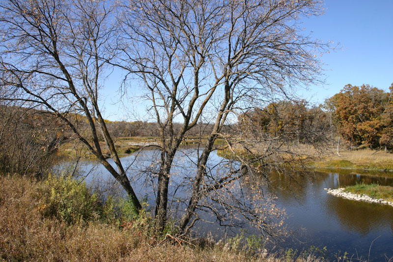 The
Souris River at Bunclody
|