by Larry Laliberte
Winnipeg, Manitoba
|
Manitoba Historical Maps on Flickr
Manitoba has a rich legacy of cartographic material, printed throughout the progression from Rupert’s Land to Postage Stamp Province to Gateway to the West. While the cartographic material is numerous, its location is scattered throughout many different institutions, including Library and Archives Canada, Archives of Manitoba and the University of Manitoba Archives & Special Collections, not to mention many other specialized collections scattered throughout the province. The goal of the historical maps of Manitoba digital collection will be the ongoing, identification, location, scanning and displaying of these intriguing images over the Internet.
While there are many bibliographies of cartographic material relating to Manitoba, for the purposes of identifying material for the online collection, the Manitoba Historical Atlas: A Selection of Facsimile Maps, Plans and Sketches from 1612 to 1969 by John Warkentin and Richard Ruggles will be used. The 585 page publication by the Manitoba Historical Society contains a wealth of information on Manitoba’s cartographic past, with over 300 maps cited, including the location of the original and annotated, providing commentary about the circumstances surrounding the creation of a particular map or series of maps. While the atlas also provides reproductions of each map cited and annotated, the illustrations are black and white, often only a section of a larger map and most of the maps are at a resolution that does not allow readers to explore the maps at a refined level. Through scanning, these maps can be brought into the digital realm, where their content, colours, textures and icons can be explored and rediscovered by all Manitobans with an Internet connection.
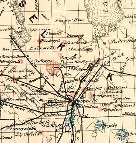
School map. A portion of a map showing school districts before passage of the 1890 Manitoba School Act. Colors were used to denote Protestant, Roman Catholic, and public schools.
In order to digitally convert the printed maps, the project has utilized The University of Manitoba Libraries (UML), recently purchased large format, flatbed scanner that can quickly digitize an area up to 24 x 36 inches at a very high resolution and save the resulting image in a wide variety of file formats. Furthermore, because the scanner is a flatbed model, fragile and/or folded maps still attached to original reports, can be gently laid onto the surface and scanned. It is important to note that not all of the original maps will have to be scanned at the UML. For example, maps identified through Library and Archives Canada’s online research tools can be purchased as high resolution scans which can be added to the online collection, saving researchers and the public time and money in exploring Manitoba’s spatial history. Once a map is scanned, the digital image and associated metadata (title, author, publisher, year, scale, legend information, etc.) are uploaded to Flickr, an online photo sharing community and repository containing over 2 billion images.
One might ask, why Flickr for maps, if it is a photography website? Simple. Maps are graphic records, snapshots of spatial extents, an image, and like photos a pictorial abstraction of time and place. Flickr is also a great venue for displaying and distributing maps as the site provides a flexible set of tools for uploading, organizing, annotating, creating metadata or tagging, embedding, downloading and sharing digital maps. A very powerful feature in Flickr is its built-in Really Simple Syndication or RSS Feed, which alerts individuals who subscribe to Manitoba Historical Maps when new maps have been added to the site.
Flickr is also a community of users who create themed based groups like Old Maps and Manitoba Sights where images can be contributed and content discussed. Users can also comment on images and compare notes. For example, a member of the Flickr community noticed that two Winnipeg streets, Grosvenor and Dorchester, are erroneously transposed on the Manitoba Historical Maps copy of a 1911 map of the city, but they were correct on his copy, indicating the mistake must have been caught and corrected in the midst of the press run. Notes can also be added directly to an image, allowing users to read text and follow any links when they mouse over parts of the map. This can be useful in highlighting, at a glace, important attributes of the map, for example, building names on a Bird’s Eye View, or indicating where Fort Garry is, to orientate viewers of more imaginative maps.
On the content provider management side, Flickr generates daily user statistics that not only indicate which maps were being viewed, but also track how people arrived at the map they are viewing. The statistics indicate that most people discover the maps by searching Flickr directly. However, many users also arrive through search engines like Google and Yahoo, and the statistic feature allows the site manager to view the actual search strings that the user typed in. Users also access the maps through other websites that have embedded Flickr generated code that streams images across web pages, based on the keywords associated with the images. A good example of this is the Best of Manitoba website which displays images as they are added to Flickr and tagged with the keyword Manitoba.
The most critical limit of Flickr for maps is that there is no built-in functionality that allows users to zoom and pan a map without leaving the Flickr site. Many institutions have developed web based map repositories using a software program called Zoomify which gives users, who merely want a quick look at a map, the ability to zoom into and pan an image. However, new scripts and plug-in software are being developed constantly for Flickr, and ideally, a program like Zoomify could be added as an icon that, once clicked, would allow zooming, panning and the ability to print just the portion of the image being viewed.
There is a 10MB per image size limit when uploading maps; however, this size limitation is offset because the images being delivered online are derived from images scanned according to digital archival standards and as a result can be compressed to under 10MB without any loss of clarity in the map’s message. The important criteria of an Internet ready copy of a printed map is that users can explore text and icons at a very detailed view as well as leverage the power and flexibility of Web 2.0 environments, to describe, embed and/or download a map image and re-channel its thematic content into value added, artistic web based creations.
Old printed maps have always been valued for how they look, especially by those who feel the art of cartography has been lost. However, historic maps are experiencing resurgence through their use in highlighting environmental issues including, urban sprawl and land use change over time as well as their growing importance when negotiating First Nations land claims. Through the use of other digital media, scanned historical maps are being enhanced by the application of various mashup techniques available in programs such as Google Earth and Geographic Information Systems (GIS), that breath new life into old maps by draping historic images on to 3D elevation data, overlaying current datasets, as well as embedding the maps with associated text, images and audio/video sources.
One of the long term goals of the project is the beginning up of an ongoing dialogue with institutions, groups and individuals who curate historical map collections in order to promote the exchange of spatial materials and services in the pursuit of ease of access, for all Manitobans, to their cartographic heritage, in a scanned digital format that lends itself to further enhancement and value added research. Finally, and no digital conversion project can avoid the question, are issues surrounding copyright. Due to their age, most of the Manitoba maps, being placed online, are in the public domain, in which case they can be shared widely with anyone and in any format. What needs to be look at however, is the issue of printed maps only 10 to 40 years old, which are hindered in their digital conversion, storage and subsequent Web 2.0 enhancement, by copyright. Perhaps for maps in this range of dates, we can weave the philosophy of creative commons and common good, and the educational value of having web access to maps that highlight recent cartographic themes in Manitoba.
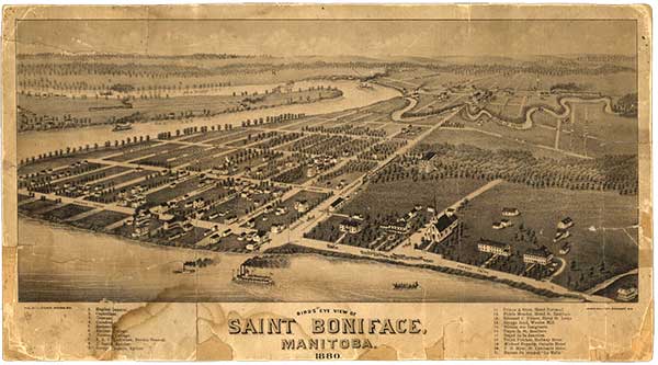
A Bird’s Eye View of Saint Boniface, 1880
Source: Gordon GoldsboroughThis remarkable image of St. Boniface was made in late 1879 by American cartographer Thaddeus Mortimer Fowler (1842-1922). Over the course of a 54-year career, Fowler made hundreds of such “bird’s eye” maps throughout the northeastern US states. During a visit to Manitoba, he also made maps at Emerson and Morris, as well as Winnipeg across the Red River. When his Winnipeg map went on sale in February 1880 (at a cost of 50 cents a copy), the Manitoba Free Press noted that “a good deal of labor has been expended in producing it, and the details are very correct, every building and street being properly located and recognizable.”
Fowler was employed by J. J. Stoner of Madison, Wisconsin who, in the mid- to late-nineteenth century, specialized in making city panoramas. These views were typically a combination map and aerial image, sketched from about 2,000 feet aloft in a hot air balloon. Whether Fowler used a balloon to draw his Manitoba maps is unknown; he may have simply extrapolated from ground maps.
A high-resolution version of the St. Boniface bird’s eye view is now available in the Flickr collection of Manitoba historical maps. It is a good example of the spirit of the Manitoba Historical Maps project, where an old map that would otherwise languish unseen in a private collection can be scanned then offered freely online to anyone with an Internet connection. In this way, rare maps will be available as a resource for generations of future historians.
Noteworthy buildings in the map were numbered: 1, Hopital General. 2, Orphelinat. 3, Couvent. 4, Catedral. 5, Archevéché. 6, Ancient College. 7, Nouveau College. 8, A. A. C. LaRiviere, Bureau General. 9, J. Smith, Epicier. 10, George Couture, Epicier. 11, Prince & frère, Hotel National. 12, Fidele Mondor, Hotel St. Boniface. 13, Edouard C. Prince, Hotel St. Louis. 14, George Reid, Woolen Mill. 15. Bâtisse des Émigrants. 16, Depot de St. Boniface. 17, Depot de la Jonction. 18, Frank Palcher, Railway Hotel. 19, Michael Fogarty, Ontario Hotel. 20, F. D. Myer, St. Lawrence Hotel. 21, Bureau du journal “Le Metis.”
Page revised: 8 June 2014