by Sharon Ewens
Emerson, Manitoba
|
Jump to:
Other historical tours in Manitoba
The first settlement around what became Emerson dates back to the beginning of the nineteenth century, and was related to the fur-trade. In the early 1800s, a Hudson Bay trading fort was established on the west side of the Red River in the vicinity of what is now Emerson. This fort remained throughout the fur-trade period an important post for the Company, and in the later settlement period became an important point on the developing trade routes—overland and by river—between the Red River Settlement (Winnipeg) and St. Paul, Minnesota. It also served as a refuelling point for the steamers that began to ply the Red River in the 1850s.
In 1871, a customs house was opened on the west side of the Red River, and the first Collector of Customs, F. T. Bradley, was appointed. Bradley became an important figure in Emerson’s early years, becoming also a director of the Emerson and Northwestern Railroad and organizing the first Masonic Lodge of which he was Worshipful Master. By 1872, the customs building also served as a telegraph, express, and post office for what was known then as North Pembina and came later to be known as West Lynne. It was later discovered that this “Canadian” customs building was actually sitting on the American side of the boundary—and was hastily dragged north! The customs house, the first in Western Canada, is now located on the north side of Highway #75 on the west side of the river, along with Emerson’s first jail, also a well-preserved log building.
In the spring of 1873, two American businessmen from Wisconsin, Thomas Carney and William Fairbanks, became interested in the land on the east side of the Red River at the Canada/U.S. border, with a view to establishing a town site at that location. The first settlers, about 100 people, arrived in that year. In 1874, the settlement was named “Emerson,” after Ralph Waldo Emerson, who was William Fairbanks’ favourite writer.
It was not until 1876 that population had increased to the point where the establishment of churches and a school was warranted. The first school was a temporary one-room structure, but the Church of England built a permanent structure which still stands today at the corner of First and Church Streets. Emerson became a trading centre for an area that stretched 200 miles westward along the international boundary, and by 1878 the town was beginning to reveal the effects of prosperity—a prosperity which was accelerated by the arrival of the rail-road in 1878. In 1878, the first newspaper, the Emerson International, was begun by C. S. Douglas—also an American from Wisconsin. Douglas was later elected to the Manitoba Provincial Legislature, and in later years became mayor of Vancouver.
The “boom” years between 1880 and 1883 saw a dramatic increase in Emerson’s population and by 1883 it had reached approximately 10,000 people. Large, elaborate public buildings such as the McKay Block, the Alexander Block, and the Anglo-American Hotel graced Main Street. A Town Hall and Court House in the popular “Italianate” style was erected at the corner of Church and Winnipeg Streets. This building burned in 1917, and the present Town Hall—a Provincially Designated Heritage Building—was constructed in that year. Most of the other large, public buildings existed well into the 1960s, but had suffered over the years from fires and Emerson’s famous floods. The erection of the permanent dike around the town marked the end for these early, grandiose structures, and none of these original public buildings exist today.
Still in existence from the “boom years” are a number of early homes representing several building styles popular in the early 1880s:
Pocock House, circa 1882—the only stone building in Emerson—built as a replica of Mrs. Pocock’s family home in England.
Ambrose Stock House, 1882—Ambrose Stock came from Ontario to fight against Riel in 1870, then settled in Emerson and became the first school teacher in the area. The house is typical of modest frame construction of the period. After being empty since 1957, the building is now undergoing restoration by its current owner.
“Kelvinside,” 1880, 57 Fourth Street. First owner, Thomas Carney, one of Emerson’s founders. Also owned from 1882-1884 by Edward L. Drewry who later founded Drewry’s Brewery in Winnipeg. Now restored as Aunt Maud’s Tea Room.
57 Fourth Street (closed as of 2006)
Source: Gordon Goldsborough
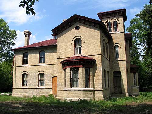
Fairbanks Mansion, 1881. North side of town between Second and Third Streets. Built for William Fairbanks, this home is built in the “Italianate Villa Style” and no expense was spared by the wealthy Fairbanks in its construction. The house had been the residence of the Forrester family for over 100 years. Constructed of “Emerson” brick—distinctive yellow brick with pink undertones, produced in Emerson’s early brickyard.

Fairbanks Mansion (2006)
Source: Gordon Goldsborough
Second Empire Triplex, 1882. 33 Fourth Street. Emerson brick. The Second Empire Style was brought to Manitoba by settlers from southern Ontario—and remains a rare building style in this province. This building is one of only seven examples in Manitoba, and the only “triplex.” A Municipally Designated Heritage Building.
Bryce House, 1883. 99 Assiniboine Street. A smaller version of the Italianate Style, this home was built by John Bryce, an early builder and owner of the Emerson brickyard, as his residence. This building is the last example of Emerson’s first building boom which ended in 1883. A Municipally Designated Heritage Building.
“Bryce House,” 99 Assiniboine Street, Emerson. This house was constructed in 1883.
Source: Sharon Ewens
E. Casselman, Mayor of Emerson at the turn of the century, became interested in the concept of early “concrete block” construction and was responsible for the building of the following two homes:
Casselman Residence, circa 1901. Corner of Park and Third Streets. Although at one time the best example of this type of construction, the building has since undergone some inappropriate renovations. The current owner is interested in restoring the home to its original condition.
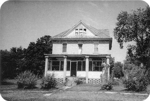
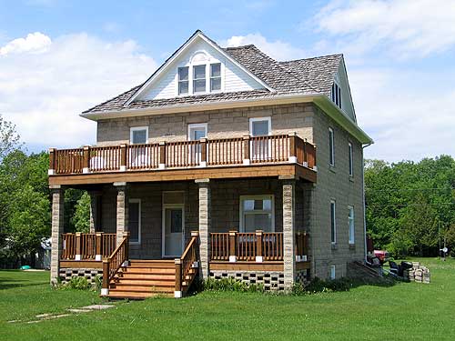
Former Presbyterian Manse, circa 1901. 128 Park Street. A Municipally Designated Heritage Building. Although now vacant, the current owner intends to restore the building.

Presbyterian Manse, Emerson (no date)
Source: Rosemary Malaher

Renovated Presbyterian Manse, Emerson (2006)
Source: Gordon Goldsborough
Also representative of the second building period which occurred at the turn of the century are:
David H. McFadden residence, circa 1901 - 119 Park Street. McFadden was a Provincial Secretary in the early years of this century, and father to Manitoba historian Molly McFadden Basken. The home is a well preserved example of frame construction in a restrained Queen Anne style. The current owners have restored the turret and porch much as they were when the house was first built.
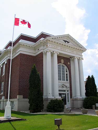
Emerson Court House and Town Hall, 1917. Corner of Church and Winnipeg Streets. Built to replace the original Town Hall which burned in 1917, Emerson’s present Town Hall is a Provincially Designated Heritage Building, and is currently undergoing major restoration of its interior.

Emerson Court House and Town Hall (2006)
Source: Gordon Goldsborough
Masonic Hall, circa 1927. Corner of Dominion and First Streets. Emerson’s first Masonic Lodge, first founded by W. H. Bradley in 1874, was located upstairs in the McKay Block on Main Street. The. present building was in use by the Masons from c. 1927 until 1992. The building is now owned by Historic Emerson Inc., who plan on opening the building as a Masonic Museum. Opening is scheduled for the spring of 1996. CP Train Station - Sixth Street at Morris Street. Designated by Canadian Pacific Railways as a Heritage Station, this original railway station is still in use for freight traffic.
Masonic Hall, Emerson (no date)
Source: Rosemary Malaher
Fort Dufferin - on the old highway to Winnipeg on the west side of the Red River. Originally established in 1873 by the North West Mounted Police (later the Royal Canadian Mounted Police) this site was also used by the International Boundary Commission in its mapping of the International Boundary in 1874. In 1995, the RCMP dedicated a statue to commemorate the NWMP’s trek west from Fort Dufferin to bring law and order to the western territories and pave the way for settlement. The statue is located in front of the Tourist Information Building on Highway #75.
Barns at Fort Dufferin (2006)
Source: Gordon Goldsborough
Officers quarters at Fort Dufferin (2006)
Source: Gordon Goldsborough
Page revised: 17 April 2016