by Graham MacDonald
Winnipeg
Manitoba History, Number 19, Spring 1990
|
Throughout the 1980s in Manitoba, a modest controversy bubbled in heritage circles with respect to the proper location of commemorative markers for the 1874 “trek” west made by the North West Mounted Police. The promotional efforts of a trans-prairie organization, the Red Coat Trail Association, were given a distinctly cool reception by certain individuals who possessed knowledge of the police route and its relationship with the slightly earlier Boundary Commission Trail. The newly-formed police force utilized many portions of this international survey route for the trek, which originated at the old Boundary Commission headquarters of Fort Dufferin just north of Emerson. At issue in this controversy was the desire by the Red Coat Trail Association to designate existing highway no. 2 as “The Red Coat Trail” tourist route, and to see this route linked with others in Saskatchewan and Alberta, eventually terminating at Fort Macleod. Signs to this effect were actually put in place along this route, although there was longstanding disagreement, both inside and outside governing circles, concerning the appropriateness of these signs. Considerable pressure was put on provincial ministers by heritage organizations such as the Post Road Heritage Group, based in Emerson, to review the designation question.
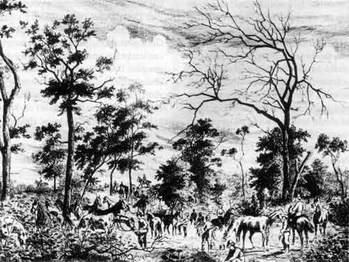
Halt of the North West Mounted Police at the Foot of the Pembina Mountains.
From the Canadian Illustrated News, 1874.
Source: Archives of Manitoba
The name of this organization requires some explanation. The ‘Post Road’ refers to Provincial Road 243 west of Emerson, and the term dates back to the days of the International Boundary Commission of 1872, and to the presence in the area by 1875 of the earliest Mennonite settlers of southern Manitoba. These settlers may be considered the earliest consistent users of a road running west from the Red River and north of the 49th parallel. One writer has noted that an examination of the maps of the Boundary Commission atlas suggests that the trail four miles west of Emerson was part of the Boundary Commission Road linking Fort Dufferin and the Pembina River but it was also, no doubt, the trail taken by the Mennonites from Fort Dufferin to points west. As such, it is likely the first stage of the development of the Post Road located along the road allowance between the first and second tier of sections from West Lynne as far as Neuhorst 24 miles to the west.
This route, or something very close to it, was also travelled by the newly organized North West Mounted Police in July of 1874, as they made their famous trek west from Fort Dufferin in order to put down troubles in the Cypress Hills and around Fort Whoop-Up in present-day Alberta.
From the Boundary Commission Atlas and from the survey maps of Dominion Surveyors in the 1870s, it is known that some easterly portions of the Boundary Commission Trail traversed American territory in the years 1872 and 1873 (following traditional Indian and fur trade routes along the course of the Pembina River). However, by the time of the great trek of 1874, an exclusively Canadian route had also come into use, for it was an important aspect of diplomacy that a Canadian armed force remain on Canadian territory when in the field. From the Diary of Commissioner French of the North West Mounted Police, there can be no doubt that the police force followed an exclusively Canadian route. After the troops had followed the Boundary Commission Trail southwest from Fort Dufferin to the point where it crossed into American territory, they followed a line of travel not far from the boundary. The third day into the trek, the police force camped at a place about 3000 yards north of the boundary line. In general, French’s route seemed to be running north and south of the Post Road, guided by the need for water and ease of passage. A year later, as has been noticed, the route was being adopted by intending settlers such as the pioneering Mennonites.
It also needs to be recognized that the original Boundary Commission Trail was one designed to be used to provision the two survey parties who were following parallel lines north and south of the 49th parallel. The trail in its earliest phase, being the child of an international joint-venture, tended to follow the path of least resistance, particularly in the country west of Emerson. Its rapid transformation into a colonization route on the Canadian side, meant that the straight line being broken by the survey party working north of the border quickly became identified with a colonization route. Hence, the route west selected by Commissioner French and his police force in 1874 and the representation on a number of maps of the 1870s and 1880s of a colonization trail of exclusively Canadian provenance. This colonization route became associated with the Boundary Commission Trail. One of the most interesting of the early maps is that prepared around 1880 by the Reverend L. O. Armstrong, a man deeply interested in the colonization of southwestern Manitoba. Wherever the Boundary Commission trail was considered to be in 1872, by 1874 its geographic location had changed, in the Manitoba perspective, to an all-Canadian route.
In recent years a considerable amount of interest has developed in the localities bordering, or near, the trail. The Post Road Heritage Group took the lead in commissioning a consulting study which looked into the status of early documentation on the Boundary Commission Trail and the current organizational requirements for focusing concerted attention on the old route for purposes of tourism development. This initiative has now been supplemented by the development of an umbrella group, the Boundary Commission North West Mounted Police Trail Association, which is seeking to coordinate the efforts of interested local societies and individuals. An integrated series of legitimate heritage and tourist development linked by the major themes, is sought by the association. There is still much to be learned about the specific location of the various trails which were used in the 1870s but for the interested researcher, amateur or professional, nothing is more fascinating than the inspection of the official Dominion Survey maps prepared after 1872, located in the Manitoba Archives. The Boundary Commission Trail is clearly marked from Emerson to the country west of Melita, Manitoba. There are many fragments of trails indicated as well, and these fragments may indicate some of the alternative routes used by those who followed a path west on strictly Canadian territory. The topography of this part of Manitoba was substantially different in these years, and the surveyors have often indicated a wealth of landscape detail regarding watercourses, woodlands, and older trails.
From the use of the survey data and later published maps one may follow the history of early colonization in southwestern Manitoba. Place names in the west Mennonite Reserve, such as Gretna, are supplemented by several little known localities further to the west. Mountain City, Pembina Crossing, Clear Water, Badger Creek, Cartwright, Wakopa (La Riviere), Turtle Mountain, and Sourisford are just some of the place-names encountered. Working from the survey maps, it quickly develops that one of the most intriguing spots along the old Boundary Commission Trail is that around present day La Riviere, east of Turtle Mountain. Here the maps show a great criss-crossing of trails moving east and west, north and south. The early store and other community buildings are shown as well. It is this kind of information that promises much for the future of an integrated trail development with associated commercial and tourist facilities as complements.
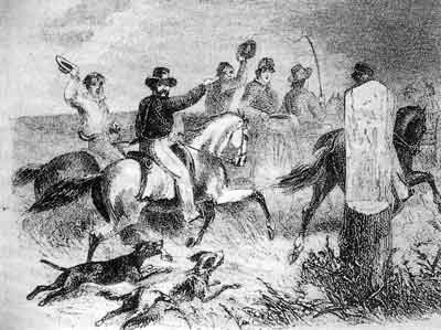
Horsemen riding near boundary marker, Fort Dufferin area.
Source: J. F. Tennant, Rough Times, Winnipeg, 1920.
Many kinds of organizations may become involved in the long-term development of this vision. For example, much good work has been done by the authorities and citizens living within the Turtle Mountain Conservation District. As part of the overall plan for this region, the heritage resources have been acknowledged and given an appropriate place in the scheme. At Melita, the late Ken Williams and his colleagues at the Antler River Historical Society have worked hard to develop a focus of attention at the old Coulter Park site at Sourisford on the Boundary Commission Trail. This is an intriguing site for many reasons, including its role as one of the earliest regularly used recreation sites in rural Manitoba. International picnics have been held there since the early 1880s. It is also a locale where genuine vestiges of the Boundary Commission Trail are still visible and can be pointed out to the local and travelling public.
Many people have taken an interest in the trail over the years, and some, such as James McClelland of Emerson and Professor Allen Kear of the University of Manitoba, have written interesting papers on the subject. Felix Kuehn is now industriously promoting the purposes of the Boundary Commission North West Mounted Police Trail Association, and is furthering research on precise trail information. In 1988, Thora Cartlidge of the University of Manitoba’s Department of Landscape Architecture undertook a useful planning study. Property owners in the vicinity of the Turtle Mountain Conservation District were canvassed with respect to their general opinions about the recreational value of the historic trails in the area. Some of the usual problems associated with the development of public access to private lands surfaced in the course of that survey, ones which have been present in the course of development of all great public trails. At the same time, there was a strong locally-expressed view that the Boundary Commission Trail was an important heritage resource and that it should be respected and developed in some appropriate way.
The great value of what is now taking place through co-operative non-government initiatives is that a heritage constituency is developing among people somewhat removed from each other in space, but who are linked by interest in a common and significant set of themes. The impulse is not merely to celebrate but also to develop, economically, areas suffering from farm economy dislocations and a population which has been losing its young people to the city. By attempting to promote the heritage opportunities associated with an important national resource, the communities along the old Boundary Commission Trail hope to add one more element to the economic diversification of southern Manitoba.
Page revised: 26 June 2015