
| Resource Collections / Documents |
Wakopa
From Trails and Crossroads to Killarney
by Aileen Garland
(Download the pdf)
|
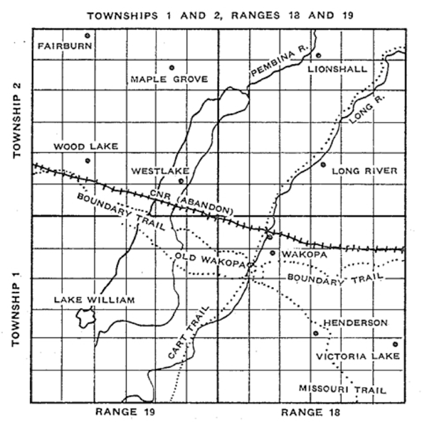
The river marked on this map
LONG RIVER is designated
By 1879 a trickle of settlers, most of them from
Ontario or
Quebec, had come into the Wakopa district. There they found that an
enterprising trader, Bernard B. LaRiviere, had established a trading
post on the Boundary Commission Trail beside Long River. According to
Alex Rankin, a pioneer in the district, LaRiviere, al- though he could
not write his own name, was a Justice of the Peace and spoke French,
English, and seven Indian dialects. CREEK in its upper reaches and WHITE MUD CREEK or WHITE MUD RIVER in its lower reaches on most Government maps. The local usage calling it LONG RIVER is used in this book. Little is known about LaRiviere's past. According to The Killarney Guide Jubilee number, July 11, 1957, he had traded with the Indians in Crookston where he had a large fur warehouse, but the officers of the law, suspecting he was selling liquor to the Indians, drove him across the border about 1874. James Scott of Boissevain in The Beckoning Hills stated that the trader came to this area on a hunting trip with his son-in-law, Clovis Guerin, and two other companions in 1876. Each of them had his own pack horse as they expected to spend several weeks hunting and exploring the area. LaRiviere was a shrewd man; he saw that settlement would extend southwest, and he planned to combine supplying the needs of the settlers with trading for furs. When the hunters came in sight of Turtle Mountain, they found a supply depot which had been built for the Boundary Commission in 1873. No one was in the building but they could see that it had been used as a stopping place. About a mile beyond the depot they found, in an elbow of Long River, a deserted Indian camping ground marked by many rings of stones, which they recognized as the weights the Assiniboines used to hold their tents down. Two Indian trails passed within a mile of the Boundary Commission Depot. One, which the surveyors in 1879 labelled on their map the Missouri Trail, ran northwest from the boundary and was connected with the Boundary Commission Trail by two short branches near the depot. The other, which the surveyors called Cart Trail from the International Boundary followed Long River. Here, where three trails met, was certainly the spot for a trader. The site he chose on W 29-1-18 was in the centre of Townships 1 and 2, Ranges 18 and 19. To the west was Turtle Mountain with its supply of timber, to the north and east good farm land. In the spring of 1877, LaRiviere and Guerin returned with several wagon loads of supplies and about twenty cattle, and set up quite a large establishment. At one time LaRiviere was the largest landholder in the district, holding 1800 acres. George Scott, who worked for him during the winter of 1880, stated that he sometimes had as many as a hundred cattle stabled in a number of small log buildings. John St. Arnold said that, when he worked there in 1882, LaRiviere had at least thirty horses for freighting or for sale to incoming homesteaders. He built his house on one side of the Trail, his trading post on the other. Thus the Trail became the main street of the settlement which grew up there. His house became an inn for travellers, often accommodating homesteaders trudging to the Land Office in Deloraine to file their claims. Opinions about the inn differ. An English visitor in 1883 reported "the inn there a miserable one, being kept by a half-breed, the occupants remarkable for their dirt." The propagandist for the Emerson and Turtle Mountain Railway in 1880 mentioned "LaRiviere's quaint trading post" and "a good host and hostess and plenty of good cheer ... We ate," he asserted, "the biggest potatoes we have ever seen and our horses were treated to as clear and full oats as they have ever reveled upon ... We saw a fine sample of wheat grown on LaRiviere's land which ran 25 bushels to the acre the first year sown upon the sod." The trading post was the chief source of supply for settlers for miles around. Prices were high. In the spring of 1880 a pioneer complained that he had to pay $8.00 for a bag of flour. That same year LaRiviere bought 2,000 bags at Nelsonville at $1.75 a bag. Transportation costs were heavy when goods had to be brought by wagon or oxcart from Emerson, Nelsonville or Morden. At first the settlement was called LaRiviere's, but local legend has it that an old Indian chief who had a high regard for LaRiviere gave it the name Wakopa which means "White Father." LaRiviere and the first settlers had only squatters' rights until the survey of the townships was completed in the spring of 1880 and a Land Office established where they could register claims. The homesteaders hardly dared leave their cabins over night for fear they would find some one in possession when they returned. The Land Officer, G. F. Newcombe, had been appointed by Order-in-Council, April 14, 1880, but he did not arrive in Deloraine until July. A letter from "Settler" published in the Manitoba Free Press of Aug. 4 states, "The long looked-for land officer has arrived but is not located yet." The office was opened before the letter was in print. J. A. Rowsome and Robert Douglas filed for homesteads in Township 1, Range 18, on August 3. There are nine entries, for August 11: James P. Alexander, John Barker, Henry and William Coulter, Robert Cowan, Richard Hammond, Neil McGill, Charles and Finlay Young. B. B. LaRiviere filed August 12, Matthew Harrison, John Melville, and Philip Scott in October, and John Coulter in November. Clovis Guerin came with LaRiviere in 1877 but because of complications about homestead and sale is not listed in the Land Office register until 1882. Joseph Kirk, who completed the survey of Township 1, Range 18, on Oct. 29, 1879, included the names of William Beaulieu, Peter Damers, Wilson and John Johnston, and Andrew McGill with notes about their buildings and fences, or lack of them. These men either did not register their claims or did not complete their homestead duties; their names are not on the Land Office register. Here also were David Allan and James Eyer (or Eayrs) who did not register for this land but filed for homesteads in Township 2-19 on August 5, 1880. The notes on the map show that John Stewart had ploughed four acres, built a log house 18 feet by 24 feet and found good water, but he sold his claim to Robert Douglas and took another homestead in 1881 in Township 2-17. In Township 1, Range 19, John Highman, John J. Blanchard, James Fleming, and Thomas Sharpe filed in October. In 2-19, in addition to David Allan and James Eyer, George Scott, and Robert J. Tyler filed in September, 1880, and William Shannon in October. No homesteads were taken up in 2-18 that year. Most of those who registered their claims in 1880 were there in 1879, waiting for the Land Office to open. The Parliamentary Guide states that J. P. Alexander, the first member elected for Turtle Mountain, and Finlay Young, the second, both came in 1879. F. H. Schofield's Story of Manitoba gives that date for the Coulters, Robert Cowan and Charles Young. Neil McGill surrendered his first claim to J. P. Alexander, so he was probably there before Alexander came. According to the Harrison story, Matthew and William Harrison and C. W. Williams built their first gristmill and sawmill at Wakopa in 1878, and the Melville family story says that John Melville came with the Harrisons in 1878 and that they brought with them the equipment for a gristmill. These were the first homesteaders in the Wakopa area who registered their claims and obtained title to their land. Seventeen filed in 1881 in Township 2-18; Alex Rankin, Orson Martin, Darius Harris, Euclide Desjardins, James Gordon, A. D. Ross, and G. B. Wilson in June; J. J. and J. M. Rankin, Samuel and Herbert Jones, Charles Gregory, James Stevenson, and Robert White in July; Auguste Demers, and John Benoit in August, and J. B. Martin in November. There were fourteen entries for 1882 in Township 2-18, three in Township 1 for 1881 and two homesteads and one sale of a half section in 1882. Of the 54 who took homesteads or bought land in Townships 1 and 2, Range 18, the Voters' List of 1895 and Mrs. A. M. High's map show that 41 of them or their heirs still held the land in 1895. By an Order-in-Council, December 27, 1880, a yearly license was granted to C. W. Williams and the Harrison brothers of Wakopa to cut timber on Sections 1, 2, 3, 12, 13 of Township 1-18 on payment of a ground rent of $10.00 a square mile and 5% royalty on all products, "the grounds for according a timber berth being that they have erected a sawmill capable of cutting 5,000 feet of lumber per diem which is doing good services in supplying the Turtle Mountain settlers with the lumber and shingles necessary for the erection of buildings on their homesteads." Harrison and Williams' first mill burned down but they promptly replaced it, for there was a lively demand for lumber and shingles. Thomas L. Fox received a license, February 28, 1881, to cut timber on six sections in Township 20 "on condition that he build a sawmill and have it in operation within twelve months." Fox built his mill on Lake Max. "That spring (1881), Wakopa was humming with activity," wrote James Henderson in The Beckoning Hills. "A new boarding house was being built on the north side of the Boundary Commission Trail which was the town's main street. A livery barn was built on the southern outskirts due east of the sawmill; west of the mill and around the bend of Long River stood the gristmill." "One day in May, 1882," according to James Scott, "one hundred and two settlers passed through Wakopa, by every mode of travel possible." Since Wakopa. was the only settlement in the district, the Council of Turtle Mountain held most of its meetings there during 1883 and 1884 until school houses were available. Clovis Guerin was the first postmaster in Wakopa. His duties were light. When the mail arrived from Emerson, it was dumped into a big box and each settler hunted out his own. The same box served as a Lost and Found depository. Later the post office was moved to C. W. Williams' store. An American Customs Office was located in Wakopa, with C. W. Williams the Customs Officer. The exports were mostly animals for breeding purposes, buffalo bones, and settlers' effects, testimony to the continuing migration to the western plains of the United States. In 1888 the Customs Office was moved to Killarney after Williams opened a store there. Henry Coulter brought in the first horse-power threshing machine in 1881. The average crop sowed at that time was small, so the farmers hauled their sheaves to a central point to save moving the outfit. Most of the grain was used locally for gristing, feed or seed. William Weir was the first blacksmith. Robert Tyler also set up a smithy on his farm. A considerable percentage of the homesteaders were bachelors who had no immediate interest in establishing schools or paying the inevitable taxes to support them. There were, however, families with children for whose education provision had to be made. The impetus for establishing a school had to come from the area the school was to serve. The School Act required a petition from at least five heads of families and evidence that there were at least ten children living within three miles of the site proposed for the school. Then the Council of the Municipality passed a bylaw forming the school district, and the petition was forwarded to the Department of Education. The principle was stated clearly by the Inspector for Protestant Schools in 1885 thus: "In accordance with the spirit of free institu- tions, the extent to which the provisions made for the establishing of schools shall be taken advantage of is left for the people themselves to decide, through municipal councils elected by them, and the limit of the burden they are willing to bear for the support of schools likewise determined through trustees chosen by them at annual meetings." Another recognized principle was "that the whole province is interested in and should bear a portion of the cost of education." In practice this meant that the smallest and weakest unit, the school district, could establish a school, and the larger units, the municipality and the provincial government were obliged to bear most of the cost. Naturally this has resulted in struggles between the elected school boards and the elected council of their municipality and in efforts by the municipal councils to persuade the provincial government to bear more of the cost. The provincial government made a grant of $10.00 a month (up to $100.00 a year) for every month the school was in session. There was also a first grant of $50.00 for the first term, regardless of the number of days. The Department of Education determined the qualifications required for teachers, which in early days meant examining the credentials of young men or women educated elsewhere and deciding whether they should be given an interim certificate. The Department also outlined the course of studies, prescribed the textbooks, and sent inspectors out to see that the schools were in session and the regulations being obeyed. The first inspectors were usually clergymen who augmented their slender stipends by the allowance they received from the Department. The first inspector in the Southwestern area was the Rev. Andrew Stewart, Methodist clergyman in the district, who in 1885 received $275.00 for inspecting twenty-four schools in Turtle Mountain and Souris River Counties. A Provincial Normal School was established in 1882 in Winnipeg and short courses leading to a 3d B certificate eventually offered in Winnipeg, Brandon, Portage la Prairie, Rapid City, and Pilot Mound. The Municipality was required by law to provide $20.00 a month for every month the school was in session. In 1883 the Municipality of Turtle Mountain levied a general school tax of 4.2 mills on Protestant ratepayers in the entire municipality to provide for the first four School Districts formed and in operation, Oak Lake (later called Killarney), Maple Grove, Wakopa, and Lyonshall. The school district tax for Wakopa was 5 mills, for the others 10 mills. The municipal councils approved the establishment of school districts, determined their boundaries and adjusted them as need arose. This procedure often led to furious disputes because no district wanted to lose a taxpayer, and often there were efforts to include a large family within the boundary to ensure that the school would remain open. The councils set the rate of the tax and endeavoured from time to time to persuade the legislature to reduce the compulsory $20.00 a month. The local school board prepared its petition, stating the proposed boundaries, the site of the school and the number of Protestant children in the district. It called for tenders for the school house, and sought authorization for debentures, usually for $500.00 or $600.00. It chose the name for the school, sometimes running into difficulty because some other school already had that name, engaged the teacher, bought the supplies (often only rough benches, a stove and a box of chalk), let contracts for supplies of fuel, and determined how long the school should remain open. Some of the contracts with teachers stated "as late in November as weather permits." On April 22, 1883, ten householders and freeholders of Wakopa met to organize a school district: John Coulter, William Coulter, Robert Cowan, Clovis Guerin, Matthew Harrison, B. B. LaRiviere, Neil McGill, C. W. Williams, Charles Young, and Finlay M. Young. The trustees elected were John Coulter, Clovis Guerin, and Neil McGill. Charles Young became secretary. Instead of waiting to build a schoolhouse, the trustees rented a building from William Weir for $2.00 a month. Mary Reeves, who lived on SW 14-2-18, obtained an interim certificate and was engaged to teach six months, from May to October, for $150.00. In 1884 the School Board issued debentures for $500.00 and Neil McGill built a school house for $387.00. For the first three years it had no desks, only benches, and a dirt floor. No one could accuse the trustees of extravagance, for the average assessment from 1883 to 1890 was only 5.14 mills on the dollar. Before Westlake School opened in 1885 and Victoria Lake in 1887, Wakopa was the only school in a radius of seven miles, and some of the pupils walked five miles to school. Until 1890 the enrolment varied from 9 to 16, and the average daily attendance from 4.8 to 10.9. Distance and weather, haying and harvesting kept the attendance low. In 1889 the school was open for ten months and the salary had risen to $35.00 a month. Mary Reeves was followed by Mary Boyd, F. L. Williams, Annie Kilpatrick, Jessie Cameron and Adelaide Muma. The school burned down in 1891 and was replaced by another at a cost of $400.00. In 1926 a larger school was built on NE 29-1-18 at a cost of $5,000.00 and the old one moved to Wakopa to be made into a house by Leslie Morgan. Wakopa School District was consolidated with Killarney, January 1, 1967. Maple Grove School District was also formed in 1883, the trustees being Joseph G. Washington, William Shannon, Humphrey Bate, and the secretary William Ryan. They chose the name, Albion, but as there was a school of that name in Langvale, they called it Maple Grove, the name of William Ryan's farm on NE 26-2-19 on which the school was situated. John Sturt's daughter, Emma, was the first teacher, having obtained an interim certificate in recognition of the education she had received in England. The first pupils were Mary, Tom and Helen Bate, Margaret Miller, William and Edith Shannon, Nathaniel (Tan) and Elizabeth Ryan. Emma Sturt was succeeded by Mrs. G. B. Wilson, who married Thomas Steel, by Ernest Coulter, and A. D. Johnson, a Master of Arts from Aberdeen University. The school was used for church services, for meetings of the Orange Lodge, and, in 1885, as headquarters of the volunteer brigade organized by William Ryan during the Saskatchewan Rebellion. When the municipal boundaries were adjusted in 1890 so that Range 19 was no longer in Turtle Mountain, Maple Grove became a union school. When Lyonshall School District was organized March 5, 1883, it was decided to place it in the exact centre of the district, so Orson Martin, Darius Harris, and George Ferguson each agreed to give an acre for the site if it fell on their land. SW 32-2-18 was chosen and George Ferguson donated the land, though legend has it that five cents changed hands to make the transaction legal. The first trustees were Samuel Jones, Charles Gregory, and George Ferguson, with Herbert Jones secretary. Orson Martin built an 18 foot by 24 foot school house at a cost of $690.00. The school census included five children of Louis Cyr, six of the Jones family, Betsy Jane Chapman, Henry Martin, Sophia and Margaret Rankin and Matthew Wilkins. Mary Reeves came to Lyonshall after Wakopa School closed, at the end of October. Her salary was $30.00 a month. In the spring she asked for $35.00 but the trustees thought that too much, so they engaged Samuel Jones' daughter, Eliza, at $25.00 a month. Her sister, Eva, filled in while Eliza attended Normal School at Pilot Mound in the spring of 1885. Except for the year 1889 when Asenath Way taught, Eliza stayed until the end of 1890, her salary then $40.00 a month. James Magwood succeeded her. Between 1883 and 1890 enrolment ranged from 12 to 27, and average attendance from a low of 6.S to a high of 14.3. Taxes were low in Lyonshall, but in August, 1890, though the inspector praised Eliza Jones, he criticized the school house, reporting no well, no lock, no ventilation, no globe, not enough blackboard nor window blinds. This led to an acrimonious exchange of letters with Inspector H. S. McLean in which the secretary criticized the inspector's use of English and choice of writing paper. Until Lyonshall Church was built, the school was used for church services. It was also used for meetings of the Council of Turtle Mountain and the item, "$2.00 for cleaning Lyonshall School," appears frequently in the minutes. It is now closed, having consolidated with Killarney, January I, 1967. Westlake School, first named Rosebank by the trustees, was organized in 1884 and opened in the spring of 1885. The first site Was on 2-2-19 but in 1918 a new school was built on SE 11-2-19 and the old one sold to be made into a residence. The first secretary was James Rankin and the first teacher Mrs. R. Richardson. Children and teacher showed up on the first day but no one had a key. Mrs. Richardson, undaunted, taught outdoors, with a large packing case for a desk, and teacher and pupils sitting on the ground. The key was located at noon at the home of John Sturt and the class moved indoors. In the spring of 1886, Mrs. Richardson went to Sanders School and Isabel Irving came to Westlake where she remained until 1889, possibly longer. (The records of the Department of Education for 1891 to 1893 are missing.) After the readjustment of the municipal boundaries in 1890, Westlake became a union school with pupils from both Morton and Turtle Mountain. Westlake was closed in 1961 because there were not enough pupils, and the few children of school age in the district given transportation to Wood Lake School. In January, 1967, both Westlake and Wood Lake School Districts were consolidated with Boissevain. Victoria Lake School District, which the trustees wanted to call Rosedale, was formed in 1887. For the first few months, James Magwood held classes in the old Barker house over a mile west of the site chosen on NE 12-1-18. He taught there for two years and was succeeded by Charles Clark. Victoria Lake was consolidated with Lena, January 1, 1961. In 1883, a by-law was passed by the Council to provide for a school to be called Bow Park. It was to take in approximately the district later served by Fairburn School. Difficulties must have arisen, either not enough pupils or shortage of teachers, for it was not until 1888 that Fairburn School, situated on 32-2-19, was opened. W. F. Musgrove was the first teacher at a salary of $40.00 a month and the enrolment was nineteen. Long River School, opened in 1893, was located on NW 10-2-18. The first trustees were John J. Rankin, chairman, J. R. Whyte, and John Lawrence. John M. Rankin was secretary. There was always one Rankin on the school board, sometimes two, and John M. Rankin was secretary for many years. At one time 29 out of the 32 children on the roll were Rankins. Annie Hodnett was the first teacher at a salary of $35.00 a month, which, after some argument, she succeeded in raising to $40.00 for the second term. Minutes of the meetings reveal that the trustees were faithful in attendance but considered their office a duty to be avoided if possible John J. Rankin repeatedly nominated others but continued to be elected himself. The trustees must have been progressive for in 1895 they bought a set of maps and an atlas from a travelling salesman, beating him down from $47.50 to $40.00, which they paid in two installments. They were not indifferent to the niceties. In 1897, they voted Elizabeth Kinley the sum of $5.00 for cleaning the school and buying window curtains and a table cover. But they were not wasteful. One year they gave John M. Rankin the lumber and hinges left over from building the stable in lieu of cash for payment of his services as secretary. In 1884, the Council passed a by-law to establish a school to be called Wood Lake, and a date was set for a meeting to elect trustees. The minutes state that there were thirteen children in the district. Nothing further appears about this school until Wood Lake was opened on NE 8-2-19 in 1893 with A. L. Webster the first teacher. The enrolment was 26 and the average attendance the first term was 13.96, so it is clear that a school was needed. As Wood Lake was only a little over three miles west of Westlake, doubtless some of the pupils had attended there. The last school to be opened in this area was Henderson, situated on 15-1-17, organized in 1904, opened in 1905, with John Nay the first teacher and Willard Treleaven the second. Of these nine schools in the four townships dealt with in this chapter, only Maple Grove, Fairburn and Henderson are still open. The others have been consolidated with Lena, Killarney, or Boissevain. The pattern of settlement was quite different in Township 1, Range 18, from that of any other township in the municipality. The railway held only sections instead of the usual sixteen. B. B. LaRiviere had built his trading post on W 29-1-18, a School Land section, but he received title for it from the Dominion Government. There were more squatters waiting for the Land Office to open than in any other township in the municipality, more taking pre-emptions, more buying additional land from the government. Of the twenty who took homesteads in 1880 and 1881, seventeen preempted another quarter section, and twelve of them bought in 1882 a total of 4,800 acres of land in this and other townships, thus averaging 720 acres each - 160 homestead, 160 pre-emption and an average of 400 purchased. Large farms are not unusual today, but in 1882 most of the pioneers had only a quarter or a half section. Obviously these men either brought money with them, or, like LaRiviere with his trading post, inn and freighting business, and the Harrisons with their gristmill and sawmill, had resources in addition to the produce of their farms. Since they bought during the boom year of 1882, it is likely that some of them hoped to sell at a profit. Fifteen of the twenty were still in the municipality in 1895, though the Harrisons had moved to Killarney and built elevators there and at Holmfield, and Finlay and Charles Young were both active in politics, and had become grain buyers and built and leased a string of elevators. The two largest landholders, B. B. LaRiviere with 1,600 acres, and J. P. Alexander, with 1,280, parted with their land in 1888. LaRiviere's was transferred to Noel Chevrier of Winnipeg, and it has been impossible to find out what happened to LaRiviere thereafter. J. P. Alexander's was transferred to the Manitoba Mortgage Company. He had moved to Sourisford in 1883 where he became registrar of deeds, and was elected to the Legislature for Souris River district in 1886. J. S. Stevenson, who was warden in 1883, surrendered his land to the London and Canadian Loan Company. These men had many companions in distress for the minute book of the municipality shows that in 1888 quite a number of farmers had either surrendered their land to mortgage companies or abandoned it. It was not unknown for a man to raise $500.00 by mortgaging his land and then disappear to make a fresh start elsewhere. When the railway reached Killarney, Ninga and Boissevain in 1886, settlements developed which became shopping centres for their surrounding districts. Wakopa, however, remained an active centre until 1905 when the Canadian Northern built its line to Deloraine, passing over a mile north of Wakopa. A new village arose on William Coulter's farm. "When the gristmill and the sawmill ceased operation," wrote James Scott in The Beckoning Hills, "and building after building was torn down or moved away, other than a few basements, like many other pioneer towns, the site once more became part of the original landscape. The waters of Long River, which had been harnessed to power the grumbling grist-mill and the whining blades of the sawmill, now flow leisurely through the old dam site and sparkle as they wend their way down Wakopa Creek and on to the Pembina River. White-tailed deer browse on the deep rutted, grass covered trail which was once the main street; and occasionally the silence is broken by the whirr of what are left of the bushland and pintail grouse." 1961 the railway from Neelin to Deloraine was taken up. The railway station and elevators are gone, and most of the buildings torn down or moved away. In June 1966, Morgan Brothers held a closing out sale for the last business establishment in the village. Wakopa's day is over. This cairn was erected by the Rural Municipality of Turtle Mountain, aided by private subscription, and unveiled July 5, 1960, to commemorate Wakopa, the first settlement in the municipality. The cairn is on the northeast quarter of Section 29, Township 1, Range 18. The actual site of the settlement was on the southern part of the southwest quarter of Section 29, east of Long River on the Boundary Commission Trail. One of the lads born in the Wakopa district, Francis Campbell Ross Douglas, has had a distinguished career. His father, Robert G. Douglas, who homesteaded W 2-1-18, taking over John Stewart's cabin and claim in 1880, was a bachelor when he came, and used to call on Mary Harrison "with his prancing steed and gig." He later married Helen Blair, daughter of a missionary in South Africa. Their son, Francis, was born on the homestead in 1889, and went to Scotland with his parents in the late nineties. He was educated at Grantown School and in Glasgow, became a member of the House of Commons during the Second World War, resigning in 1946 to serve three years as Governor of Malta. In 1950 he became Lord Douglas of Barloch, later being chosen as one of the Deputy Speakers to preside over the sessions when the Lord Chancellor was absent. |