| Index |
|
1.
Introduction - Along The Boundary Trail
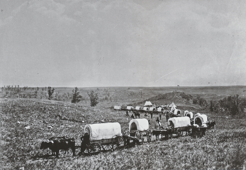
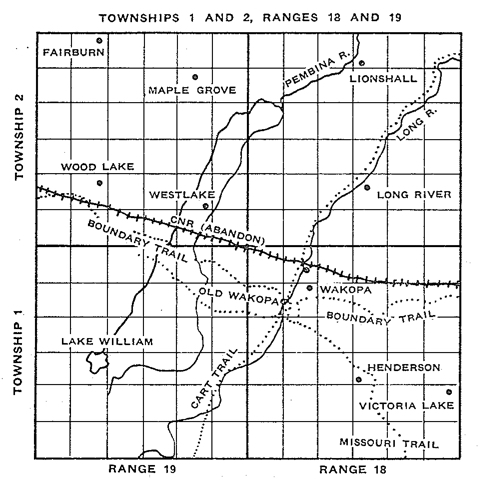
The story of Wakopa is a story of firsts. The first village in Manitoba’s Southwest Corner. The first gristmill in the region. The seat of the first Municipal Government in the region. Between 1793 and 1805 four or five trading posts were located close to each other on the Assiniboine River a few miles west of the junction with the Souris. The Northwest Company and the Hudson’s Bay Company Each had a post north of Whitewater Lake and the HBC had a post (Fort Ash) near Hartney. At this time also Alexander Henry mentions in his diary visiting Lena's House located some sixty miles from Brandon House on the slopes of the Turtle Mountains. It is known from information given us by early settlers in the Wakopa district, although there seems to be no written record of it, that the Hudson Bay Company had a post due west of Old Wakopa. This may have been the one in question. Possibly this post was located at this point in an effort to halt the flow of furs to the South via the Missouri Fur Trail. Joseph Ducharme, who was well known by the people of the Wassewa and Old Desford districts in later years, drove many wagon trains of furs, first to St. Louis and later to St. Paul. His father was one of Alexander Henry's guides in 1805-06. In the mid-1800s Manitoba was in transition as the era of the fur trade moved into the era of European agricultural settlement. In the area that would soon become Southwestern Manitoba, it all started with the trail. Setting the Scene - The Oldest Highway in the West The Boundary Commission Trail was the route taken by the Boundary Commission in 1873 & 74 as they surveyed the Canada – US Border. They bridged creeks, established crossings, and cleared bush as necessary; but the general route they followed spans centuries, crosses cultural lines, and involves a multitude of goals and purposes. Although one short period of its life at the dawn of European settlement gave the trail its name, it was well travelled long before that time. Parts of it began as a First Nations travel and trading route, which the fur traders of the 18th Century naturally used when they began penetrating the interior of Rupert's Land, as the region was called. Not too long afterwards, the Red River carts of the Métis wore grooves into the prairie sod of the trail in their pursuit of the bison as the large animals retreated ever westward. In 1818, Canada and the United States had agreed that from Lake of the Woods to the Pacific, the 49th parallel would separate the two countries, but there was no pressing need to be more specific about it. In 1870 when Canada had purchased Rupert's Land from the Hudson's Bay Company, and thoughts were turning to the possibility of large scale agricultural settlement on both sides of the border, the time had come to mark it more precisely. In September of 1872, two parties set forth from Lake of the Woods, Ontario: Her Majesty's North American Boundary Commission and the United States Northern Boundary Commission. The two parties worked in cooperation from their respective sides of the border. They each had their own astronomer who calculated the location of the 49th parallel and in the event that calculations were different, the mid-point between them was accepted as being correct. Over two summers, the Boundary Commissioners, guided by Métis scouts, were followed by labourers breaking the trail and by surveyors traveling behind. While the British commissioners traveled very lightly armed, the Americans on the other side of the border were accompanied by heavy military escort. The Dakota, who hunted on both sides of the line were often hostile towards Americans for establishing posts on sacred land and for ignoring and breaking treaties. \  A supply ox train leaves from the Long River depot, following the newly cleared Boundary Commission Trail. And so the Boundary Commission Trail, once familiar with the feet of First Nations moving to and fro and Red River carts pursuing the hunt, became accustomed to the sound of settlers heading west. The first villages in southern Manitoba were established alongside the Trail, flourishing until the railroad came to the area. For centuries the Boundary Commission Trail had served as the highway to the west, transporting goods and people. With the technology provided by the railway came a new era of prairie lifestyle and travel as it proved that it could transport everything and everyone at a much faster rate. Thus overland tracks and trails that offered intimate wafts of wild rose and yarrow fell into disuse. Evidence of the Boundary Commission Trail still exists in places such as Newcomb's Hollow and Sourisford. Emerson, by the Red River on the US border was the point of entry to all of the Canadian territory recently opened up for homesteads. The Boundary Commission Trail, rough highway though it may have been, was by 1878, very well used. The tide of settlement proceeded, creating the towns that would become Morden, Manitou, Crystal City and Cartwright. One early traveller reported that: “Passing Pilot Mound on my return west I noticed a flag flying from a pole on the mound that could be seen for miles. As I continued on west and neared 31-1-6 on the east of the section on another high knoll was a second flag which was also visible for miles. These were wonderful guides for people who settled many miles away from either side of the Trail. They stood for many years. Most everyone who travelled the Commission Trail would stop at Pancake Lake to rest and eat. Harry Coulter gave it that name one evening in 1789 when he stopped for supper and cooked his pancakes over a wolf willow fire.” In each case settlers picked a spot for a village, perhaps just a post office and store, and hoped a railway line would come by soon. Often that didn’t happen and the village would move, keeping the name or not. When the tide of settlement approached Turtle Mountain Wakopa was the place to be.  The Boundary Commission Trail
in western Manitoba.
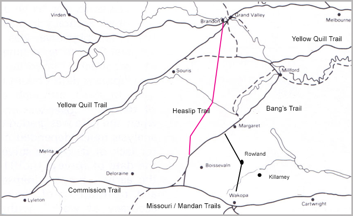
The North West Mounted Police The Boundary Commissioners finished their survey during the summer of 1874. Near the end of that year the North West Mounted Police used the Boundary Commission Trail – freshly blazed – as their avenue of travel on their trek to “establish law and order in the west” and to prepare the frontier for settlement. For a short time, they made used of the depot established near where Wakopa was located.  Transportation in the early
1880’s. Note that a few of the towns didn’t
yet exist.
Transportation Evolves… While the settlers of 1878 and '79 came by way of the Commission Trail from Emerson, by 1880 many also came by the way of the Assiniboine River to Millford, near Wawanesa, on stern wheeler, flat bottom boats, and spread south and westerly via the Rowland Trail which ran south from Lang's Valley to Rowland townsite 10-4-18. Here the trail forked. One branch went south- westerly again to the Cherry Creek district, the other continued on south to the Wakopa area, which was usually referred to as the "Wakopa Timber Trail." Then when the railway reached Brandon in late 1881, another route opened up. The Heaslip Trail crossed the Souris River at Sheppard's ferry near where Highway 10 crosses today, then southerly to the town sites situated near or on the Commission Trail When the Manitoba South Western Railway reached Cherry Creek, soon known as Boissevain, in early 1886 everything changed again. But up until that time, Wakopa was the primary commercial settlement in the region.  |
