
The
Story
told by
Maps
Maps are the best way we have to visually grasp
the physical reality of settlement patterns for a time when
photographic record is sparse to non-existent. Other records will give
us statistics, names and numbers; but it is through maps that we get
the big picture. This section documents some of the available maps and
traces the evolution of the communities in the Melita area.
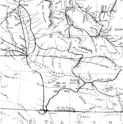
If, in 1858, one were to follow the course of the Souris Rivers
upstream from its mouth near Wawanesa, one would walk past Melita. On
the way one would encounter no farms, no roads, no villages, and few,
if any, humans. In fact, in 1858 an expedition led by Henry Youle Hind
did just that. Explorers in those days were especially interested in
rivers and would follow them anywhere.
Map 1. Hind 1858
His map shows landmarks we still recognize today, notably, the Turtle
Mountains. It would be a lonely walk. You might pass a small band of
Assiniboine on the lookout for the rapidly disappearing buffalo or
other game. You might meet a traveler, straying from the established
trail, also on the hunt.
Map 2. Dawson 1859
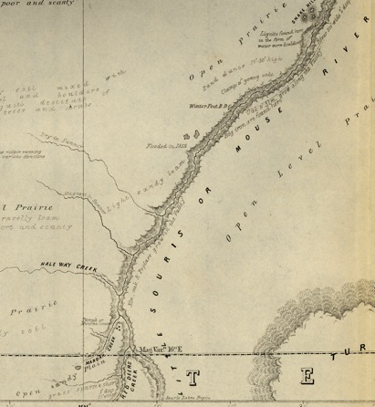
Dawson’s map from 1859 contains a bit more detail concerning the
landforms. Compare it to a modern map and note some of the
waterways have had name changes.
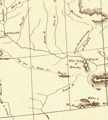
Jump ahead over a decade and look at this map prepared by a Mr. Laurie
in 1870.
Map 3. Laurie, 1870
Not much had changed. It looks like he basically copied Mr. Hind’s work
– secure in the knowledge that nothing had changed. Not only were there
no settlements, but settlements weren’t even anticipated in the near
future. It is true that the Federal government under John A. MacDonald
were determined to colonize the west, having just acquired a huge
portion of it from the Hudson Bay Company, and to that end were
planning a trans-continental railway that would link eastern Canada
with British Columbia. Convention wisdom said they were nuts. Today we
say they were visionaries.
Map 4. Manitoba (SW) 1876
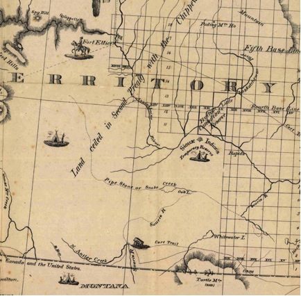
By 1876 settlement was beginning to be anticipated. Grids mark
land that had been surveyed. The Cart Trail indicated some traffic.
Indeed both the Boundary Commission and the Northwest Mounted Police
had crossed the Melita area.
Regardless, any new settlement seemed destined to happen elsewhere.
All bets were that the railway, if it ever got off of the ground, would
follow the northern route leaving the southern plains as they were.
The choice of this route was based on exhaustive research by two
extensive exploratory expeditions. John Palliser, an Irish gentleman
adventurer, who had already traveled widely in the American West, was
selected by the Royal Geographical Society and the Imperial Government
to explore the area between Lakes Superior and the Rockies and report
on everything from plant species to possible travel routes. After a
two-year field trip he concluded that the only good land in the area
lay in a belt along the North Saskatchewan. In fact the vast area
comprising the southern third of Saskatchewan and Alberta, now called
Palliser’s Triangle, was deemed thoroughly unsuited to agriculture.
Another expedition, sponsored by Canada and lead By Henry Youle Hind, a
geology professor from Toronto, came to similar conclusions. There was,
apparently, no real future for the southern prairies. Normally,
railways are built where the customers are. In this case the railways
came before the customers, so it was a case of deciding where the
customers would end up.
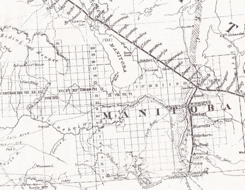
Map 5. Fleming Survey 1877
They had even gone so far as naming the stops, but before long opinions
had begun to change and a more southerly route was being considered for
at least the Manitoba portion of the line.
The decision, or more significantly, its approval by the government,
may also have rested on a few other foundations. Politically it was
advisable to located closer to the American border to preempt possible
competition from an American line and to keep a firm grip on the
territory at a time when many prominent Americans viewed the annexation
of the west by the US as not only desirable, but inevitable. On a more
practical note we were probably seeing the beginnings of the C.P.R’s
policy of avoiding high prices and land speculation by bypassing
expected routes and established communities. They truly were doing the
unexpected in this case. Additionally the southern route was shorter
and would be (they thought!) less expensive to build. Some have
speculated Mr. Hill saw the possibility of some arrangement whereby his
other venture the Great Northern in the U.S. would benefit from some
arrangements with the C.P.R.
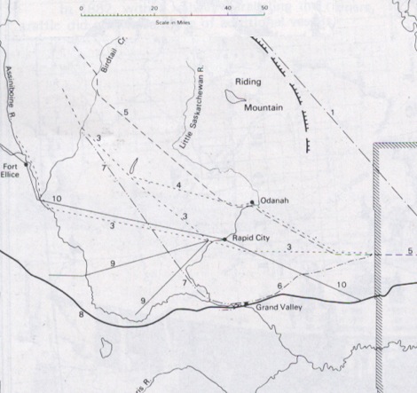
Map 6. Proposed Railway Lines in Western Manitoba
So things had changed, and by 1880 a rush of settlement was
anticipated. A transcontinental railway was becoming more than just
rumours and a pipe dream, and numerous proposals had surfaced for rail
connections lines throughout Manitoba. Note that none of these
proposals seemed to consider the possibility of even branch lines into
the Manitoba southwest.
1. Original 1872 proposal for the main C.P.R. At that time the belief
was that the Saskatchewan River Valley was the best place for
settlement, and the line was to proceed northwest from the crossing at
Selkirk. The first surveyed proposal, not shown on this map, actually
went through the narrows of lake Manitoba instead of along the eastern
edge of Riding mountain. Both ended up near Swan River before heading
west.
Numbers 3 - 7 were routes examined between 1877 and 1880
Route number 7 is from an idea Sanford Fleming, the Dominion Surveyor
had while visiting what would become the Brandon area before he
actually fully planned this southern line, which in 1880 was expected
to be the final decision. The idea was to proceed eastward from
Winnipeg and to veer northwest from Portage, with Edmonton and the
Yellowhead Pass the ultimate pathway to the west coast. Had that
happened the whole course of settlement history would have been
drastically altered for the Melita region and the rest of Western
Manitoba.
But what did happened, was that, at the last minute, with the rails
being set down almost as far as Portage a decision was made to follow a
more southerly route. Route #8 is where the track went in 1881-82 and
the rest is history. That spurred the next big speculative frenzy –
predicting where branch lines would go.
Number 9 shows just one early example – the proposal for the Souris and
Rocky Mountain Railway planned in1880. Dozens of ideas would follow,
with only a handful ever coming into being.
By 1880 this largely unpopulated area was slowly developing the first
tentative forays into agriculture with the noticeable beginnings of
towns seen at Rapid City, Minnedosa (Tanner’s Crossing), Millford (near
the confluence of the Souris and Assiniboine Rivers), and Grand Valley
(a few kilometers east of Brandon). These locations are mentioned
in the George Wyatt’s 1881 “Guide for Settlers”, which includes a list
of post offices and charts with destinations for both steamboat and
stagecoaches, while the site that would later become Brandon was an
undeveloped homestead.
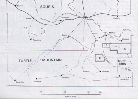
Map 7. Stage and Mail Routes
This map, showing stage coach and mail service in the early 1880’s show
the links. The locations mark Post Offices, not necessarily towns.
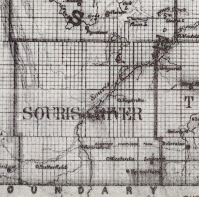
Map 8. Deville 1883
This next map ( 1883 - DeVille) we see additional place names
appearing. The names Waskada, Napinka and Sourisford have lived on
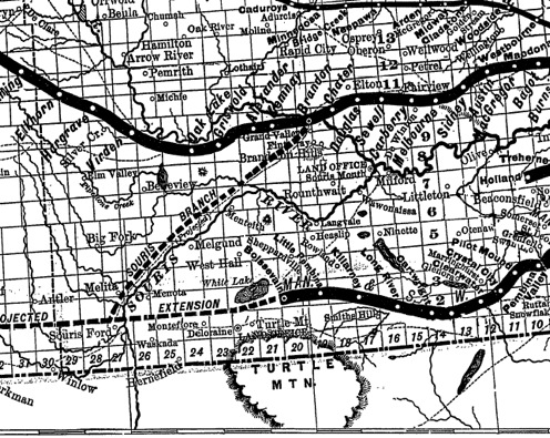
Map 9. C.P.R.Lines 1886
This 1886 map as well shows a proposed railway branch from Brandon to
Melita.
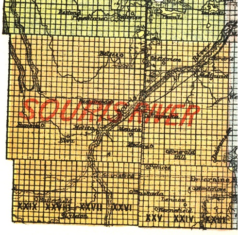
Map 10. 1891
By 1891 we see a few more changes. Note the locations of Elva and
Medora.
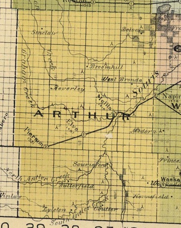
Map 11. Provincial Government Map, 1900
As of 1900 we see that Pierson & Elva were added to the Brandon –
Melita Branch.
So that‘s the way things looked at the beginning of the 19th century as
the settlers who had taken the risks, made the journeys, worked to
establish farms, and established schools and churches; waited
(patiently) for long promised railway lines that would push both
economic and social development to the next level.
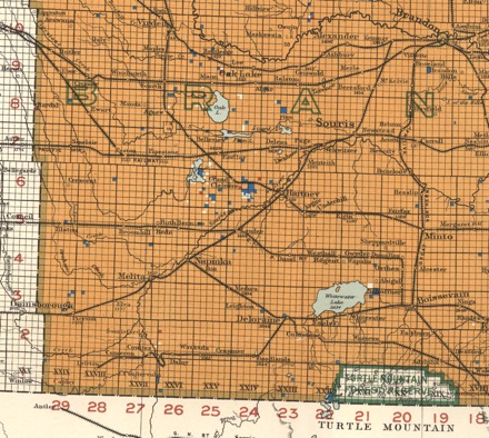
Map 12. Manitoba in 1915
By 1915 rail lines had been extended so that most farmers had less than
10km to haul grain to an elevator. Note the lines from Lauder through
to Tilston, and from Deloraine to Waskada and Lyleton. The towns and
villages as we know them in 2012 had been established.
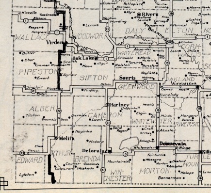
Map 13. Manitoba Highways 1924
This highway map from 1924 shows the network of roads being developed
as the automobile became our first choice in transportation.
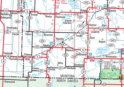
Map 14. Manitoba Road Map 2010
The 2010 Highways Map shows which villages and place names have
remained.
What the map doesn’t show is that other placed names, recalling sites
and building long gone, live on in the form of cairns
(Sourisford), road signs, and of course in our excellent local
history: “Our First Century”.
|
|