

3. The
Fur Trade
|
 Brandon
House – on the Assiniboine River south-east of the Brandon,
(Archives of Manitoba)
Brandon
House – on the Assiniboine River south-east of the Brandon,
(Archives of Manitoba)
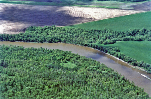
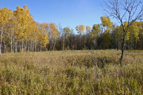
About three miles north of the little village of Treesbank the Souris
River empties into the Assiniboine. The site today is virtually
uninhabited and this area that was once the hub of commerce and
communication, in both the days of the fur trade and the early pioneer
times, shows little evidence of it's busy past. In pioneer times it was
home to one of the first Land Titles Offices in the area, one of the
first post offices, and a school. Millford, just upstream, was a
thriving boom town. Earlier, around 1800, it was home to trading posts
that represented the interests of the major trading companies; The
Hudson Bay Company, The Northwest Company, the XY Company, and the
independents.
When the first traders set up posts near the mouth of the Souris River,
just before 1800, they were surprised that some neighboring natives
could recite Catholic prayers. This was a tribute to the persuasive
powers of a priest brought to the region by Sieur de La Verendrye some
five decades earlier. LaVerendrye did not establish any posts in the
immediate vicinity, but he did do enough exploring (or consultation
with the native inhabitants) to map the area roughly.
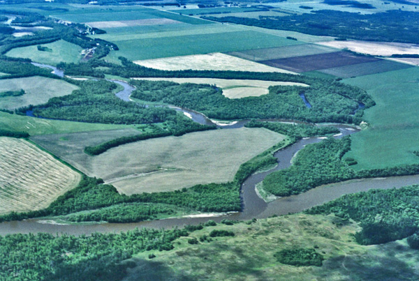
The first Brandon House was located in the small clearing just right of
centre, about 100 metres north of the river. The YY and Northwest Co.
posts were opposite.
Before the traders, and before LaVerendrye, the area was home to the
Nakota, whom they called the Stone Indians (Ossinepoilles /
Assiniboines), The visitors assigned them that name from their practice
of using hot stones to cook meat. A hole in ground lined was lined with
buffalo hide. Water was poured in, meat was added and then they put in
heated stones. This method served them well until kettles we
introduced. While the traders of the Northwest Company referred to the
major tributary of the Red River as the "Upper Red", it was soon
generally known as the Assiniboine, and the territory surrounding it
was "Assiniboia".
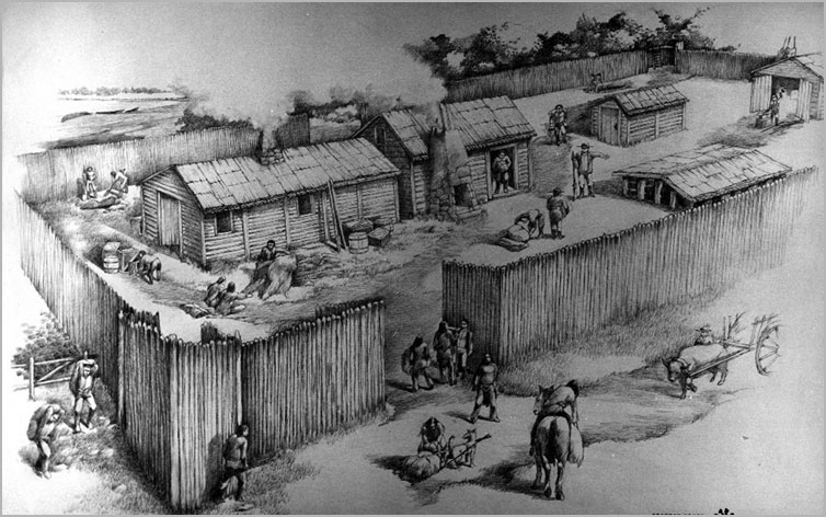
In the period around beginning of the 19th century, as many as five
competing trading posts were operating in the Souris Mouth area. They
were often similar in pattern. They had to be strategically created for
defense against, yet for trade with, the Aboriginal people. They were
near the old trails, on knolls or elevations.
This
photo was taken from the north. The first Brandon House was
located in the small clearing just right of centre, about 100 metres
north of the river. The YY and Northwest Co. posts were south of the
river.
The
Souris enters the Assiniboine
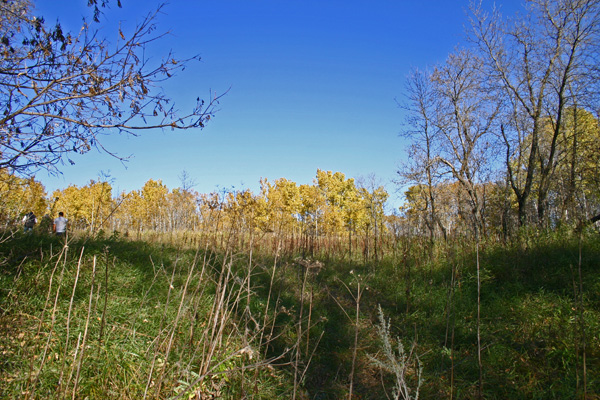
Approaching the Brandon House site from the
river, in 2017.
A slight depression, formerly a basement, is one of the few remaining
signs of human habitation is of 2017.
A stockade was built, possibly of 8 - 10 ft. poles. The buildings would
usually include a two story structure like a hotel that served as a
store. It was located just inside gate and had two parts - one with a
counter open to Indians - the other for stores and arms Several
dwellings provided residences for the "Winterers" (more important
factors or managers).
The XY and La Souris Forts
Internal strife in the Northwest Company caused the breakaway of a
group who called themselves the XY Company, so named for the large XY
they marked on their bales of fur to distinguish them from the produce
of the North West Co. They located on the south bank across from
Assiniboine House. In 1805 the breakaway XY co reunited with the NW
Co.. Both Fort XY and Fort Assiniboine closed and a new fort was built
in same quarter section on the south bank.
The rivalry between the competing fur traders was carried on in a
somewhat gentlemanly fashion for many years. Harmon recounts the story
of his visit to the Souris Mouth area in 1805 that Mr. Chaboillez, the
manager of the Northwest fort invited people of the other two forts to
a ball. Drinking went on into the night and was followed up with
breakfast in the morning. The trade had its ups and downs, but when
game was abundant there was food for all and trade enough to support
the various factions. Other forces were coming into play however. Lord
Selkirk's Red River Settlement was not well received by the Northwest
Company and many of the Metis who made their livings trading and
hunting. As competition became fiercer, hostilities broke out.
In 1816 a group of Metis, who were in league with the Northwesters
(some would say manipulated by them), and who were on their way to what
eventually became known as the massacre at Seven Oaks, looted and
burned the buildings at Brandon House. This was in response to an HBC
edict banning trade in pemmican, which was in turn a measure to ensure
adequate supply for the Red River colonists. It was rebuilt in summer
and fall but was again attacked. A decision was made to rebuild on the
south side of the river. Peter Fidler who was in charge at the time
reports that in 1818 it was comprised of smith and cooper's shops, a
trading room, provisions stores, stables, and houses. It was rebuilt
twice more and operated at a location upstream, overlooking Glen
Souris, from 1828 until it was closed in 1832.
Life in the Forts
The inhabitants of the forts varied with seasons. The more or less
permanent guards stayed year round with their wives and children.
Various hunters and peddlers were less permanent residents. The traders
set out from Michilmacimac or Fort William in early spring. The boats
were rowed by "comers and goers" also called "the pork eaters". It was
a two month trip. They brought rolls of Brazil tobacco, kegs of powder,
cloth, wine, vermilion, beads, and axes. All value was computed in
reference to beaver pelts. For example, one horse would equal sixty
skins, a gun might be fifteen skins.
The People
No account of the times would be complete without at least a brief look
at some of the central characters. The Hudson Bay Company, in
particular, has kept records of its commerce in the area but for more
personal accounts we must rely on diaries, letters and journals. In
fact several of the key figures in the exploration and exploitation of
the area kept detailed journals.
At Brandon House in 1815 the bourgeois in charge was a surveyor by
trade named Peter Fidler. Peter had, by that time, had a wide variety
of experience across the west. Thanks to him we have some detailed
accounts of life in that time and place. His reports on the daily life
of the fort he managed and visited help give us a picture. He also left
us with a rather good map of the region, though why it was drawn upside
down we don't know.
As was the custom, he married an aboriginal wife. In other ways he was
quite the eccentric. He is remembered for his rather unique will. He
stipulated that, after other dispositions the remaining money was to be
put in "public funds and the interest annually to be added to the
capital" until 1969 (200 years after his birth and that the proceeds be
given to the male heir in direct descent from his son Peter. He
miscalculated, however, as there was no money left to invest. He was
both eccentric and a bit optimistic.
The explorer David Thompson called Assiniboine House home for just over
two months. This was just shortly after he quit the employ of the
Hudson Bay Co, when they insisted he stop his exploration and map
activities and concentrate on the fur trade. The rival Northwest
Company was only too happy to enlist his services. He set out from
Assiniboine House on Tue. Nov. 28 1797 on a journey south. On Dec. 7 he
stayed at Ash House near Hartney. He traveled to the Missouri River. On
the way back he stopped at Souris (Plum Creek). He arrived back at
Assiniboine House on Feb. Feb. 3 1798. He also explored the sand hills
that winter.
Thompson was a bit of a bit of an exception to the pattern his
contemporaries had established. Being a devoutly religious man who
neither drank nor cursed, he spoke out against the trading of alcohol
to the Indians and seemed to be a defender of Indian culture in
general. And although he did follow the custom of taking a native wife,
unlike many others he regarded it as a permanent arrangement. His
fourteen-year-old bride probably had no cause to expect such a
commitment. They did indeed stay together 'til death." and raised
thirteen children together.
For several years Alexander Henry (The Younger), another explorer who
was to go on to bigger and better things, was stationed at the
Northwest Fort at Pembina, where in addition to supervising operations
there he experimented with gardening and kept a pet bear. On July 7,
1806 he set out from Pembina on a journey to the Mandan Villages in the
Missouri River territory. He stopped at Pine Fort on July 12. He passed
through the sand hills, to Brandon House (the opposing company), and
they ferried him across to La Souris House. After two days rest he set
out again on July 14 with seven men and eight horses.
He passed from Brandon House, over the Moosehead Hills (Brandon Hills)
noted Lake Clementi and the view to the north where he could make out
the spot where the Rapid River (Little Saskatchewan) entered the
Assiniboine.
He stopped at Ash House near Hartney before going south to Mandan
country. He returned to La Souris on August 9 by way of the Turtle
Mountains. He crossed the Souris at a place he called the Grand Passage
- between Margaret and Nesbitt a few miles above the input from the
Rib-Bone lakes.
His journals contain a matter-of-fact daily account of his life and
travels. They reveal a man who had little respect for his native
contemporaries. Although he did acknowledge that the liquor trade was
destroying them, he pressed on with business as usual.
Agriculture & Food
From the start the fur traders tried to supplement their provisions
with some form of agriculture with mixed results. Cucumbers, melons and
onions were grown. Potatoes had been introduced as early as 1780.
Cabbages and turnip were main crops for a time. Wheat was grown, and
oats were tried.
Wild rice was harvested in small lakes east of Brandon House. The
rivers were full of fish. In the spring sturgeon would go upstream from
Lake Winnipeg as high as the Shell River. The Aboriginals would build
fences in the rivers to keep them from returning. In 1811 seed
potatoes, horses, and perhaps seed grain were available at Brandon
House.
The Hartney – Lauder Posts
Two groups of fur trading posts played a unique role in the history of
the Southwest Corner. Whereas the relatively short-lived Souris
Mouth Posts were an important first step in the transition to the
European based agricultural society that would later develop, the posts
along the Souris in the Hartney-Lauder area provided a more direct link
between the fur-trade economy and the settlement era.
The Lauder Sandhills
The Lauder Sandhills, were created between 10,000 and 8,000 years ago,
when the glaciers from the last ice age receded to the north, leaving
huge lakes in their wake. Glacial Lake Hind covered the area around
present-day Hartney. Over the site of the Lauder Sandhills a delta
formed where a river ran into the still body of Lake Hind. Sand
deposits built up over this spot and remained after the glacial lakes
had drained from the landscape.
As European activity and settlement around Red River increased, the
bison retreated westward and were attracted to the shelter provided by
the Lauder Sandhills. The nearby the Souris River and surrounding
grasslands made the hills an appealing sanctuary. The first fur trade
posts in the Southwest Corner were located along the Souris River in
the sandhills,
European fur traders began visiting the Souris River in the late 1770s
to take advantage of the fur bearing creatures that lived along its
banks. Starting in 1795, traders were building trading posts farther
west, along the Souris River. Between Hartney and Lauder, four
important posts have been identified. These posts were along the river
and close to the grazing grounds of the buffalo. The production
and supply of pemmican, was a big part of their business. The posts had
access to the surrounding plains - the grazing grounds of the bison and
were key to the production and supply of pemmican, which supported the
rest of the fur trade.
The first fur post established on the river was Ash Fort in 1795 by the
X.Y. Fur Trading Company. Canadian explorer David Thompson spent about
two days in the region in December of 1797.
The American Fort
On the north bank of the Souris, almost straight north of Lauder, is a
site locals referred to as the American Fort, likely built by the
American Fur Company in about 1810. The size of its chimney mounds
indicate that it was in operation for some time, but few records have
been found to tell us more.
Fort Mr. Grant
In 1824, Cuthbert Grant, a youthful Metis leader was encouraged by HBC
Governor Simpson, to counter competition from Americans and other
independent fur traders in the Souris Valley. He built Fort Grant on
the Souris River, about two miles southwest of Hartney.
Maria, daughter of Cuthbert Grant, was born in 1820. She married Armand
Breland who played an important part in the trading posts on the Souris
River, and whose son, Thomas, would be one of the first homesteaders in
Grande Clairiere.
Fort Grant operated from 1824-1861, part of this time as a winter fort
only.
Fort Desjarlais
In 1836, Joseph Desjarlais, a man the Indians called “Hairy Legs" and
who seemed to have a special status with the Indians established his
post a few kilometres upstream, directly north of Lauder.
It featured a sturdy oak palisade surrounding a long log building and
several smaller ones. The Souris River ran past the south wall. As the
site was in the territory frequented by Dakota war parties it was well
protected. At its peak there would often be over seventy men at the
fort. It operated for about twenty years, and was likely destroyed in
the great prairie fire that swept the region in 1856.
It is believed that Desjarlais and his men were also buffalo hunters -
trading buffalo robes and selling pemmican to the Hudson Bay Company.
Hartney area resident Madame LaFontaine, whose father, Francois Jeannot
worked in both forts Grant and Desjarlais, is another link to the Fur
Trade era. She married one of the workers at Fort Desjarlais and
gave birth to Philomene (Vodon) and a son, Pierre, who together were
have provided modern historians with first hand accounts of life at
these posts.
This fort was very large for this area and few forts or posts Western
Canada operated for such a long time.
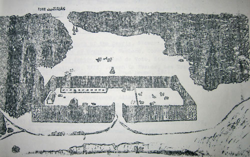 A
sketch from the “Souris Valley Plains” by Larry Clarke, based upon
his extensive research.
A
sketch from the “Souris Valley Plains” by Larry Clarke, based upon
his extensive research.
A contingent of about 75 men occupied the post - perhaps so many were
needed as protection from Cuthbert Grant. Grant's job was to remove the
independent traders from the plains and stop trading with the
Americans. Desjarlais had strong connections with the American Indians,
so perhaps the post was an organized attempt by the Metis to continue
this illegal trade.
Canadian fur traders used rum and wine extensively in their trade with
the Indian' The volume of liquor was increased by mixing it with
chewing tobacco, red pepper, red ink and water. This mixture was called
"firewater". Joseph Desjarlais was charged on many occasions, by the
Fort Garry authorities for his practice of using liquor to deal with
the Indians. There also exists the possibility that Desjarlais was
smuggling American corn liquor into Canada and Canadian furs into the
United States.
A Changing Economy
Around 1850 the fur trade was becoming a less important part of the
economy of our country.
The young Dominion of Canada was turning its attention away from the
industry of the fur trade and towards the agenda of agricultural
settlement. During 1873 and 1874 the international boundary between
Canada and the United States was marked and both countries began
surveying the land, judging its suitability for agriculture and
dividing it into the section-township-range system – for use as farms.
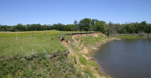 The
Desjarlais site in 2016
The
Desjarlais site in 2016
A
New Era
By 1850 independent traders in collusion with American fur buyers were
destroying the HBC monopoly. The Red River Colony also resisted efforts
to enforce the monopoly. The forts at Souris Mouth had all been
abandoned by 1832. Fort Ellice, many miles upstream on the Assiniboine
became the focal point for the HBC, while the forts of independents and
Americans were located in the Hartney - Lauder area.
At the same time, railroads were being built westward in the US,
threatening the Great Lakes trade route. North-South trade routes were
established and flourished. The HBC was losing control.
Was agriculture viable on these prairies? The HBC wasn't interested in
an objective answer, but many years earlier the people in charge of the
forts had already determined much earlier that "anything will grow
here." But could it be grown in quantities, and efficiently enough to
still be a cash crop once you factor in transportation to the market -
meaning the cities of Upper and Lower Canada?
The Canadian government commissioned Professor Henry Youle Hind, a
Toronto geologist to explore the region in light of that question.
During the summer of 1859 he and his party of 13 men explored
southwestern Manitoba. They camped at the mouth of the Souris and took
the first photographs of that river. They were particularly impressed
by the grasshoppers which Hind insisted took only ten minutes to
destroy three pairs of woolen trousers, but they also noticed the
numbers of fish rising to catch grasshoppers. They were watchful of the
Sioux whom Hind called the "tigers of the plains", and they noted the
beauty of the Brandon Hills. They noted the lack of timber, but found
what they were looking for - fertile land.
By this time the invention of machine pressed cloth felt was beginning
to kill the beaver trade. Glossy top hats replaced "beavers" as
fashionable headgear in Western Europe. Lower demand for beaver,
coupled with the fact that they were increasingly hard (time-consuming,
expensive) to find, spelled the beginning of the end for the fur
trade.
In 1869 HBC sold most of Rupert's Land to Dominion of Canada. In 1870
Manitoba joined as the fifth province. Before long settlers lured by
cheap land - "without the tedious and exhausting labour of years
required in woodland farming...." were finding their way westward.
For $10 you got a quarter section provided certain improvements were
made within a three year period. You could also apply for a pre-emption
on an additional quarter. It was too good a deal for an adventuresome
person to pass up.
The Manitoba Boom of the 1870's and 80's affected the Souris Mouth
particularly in the years from 1879 to 1882.
In 1879 the first European settlers to the Westman area were favouring
the region to the north of the Assiniboine. The wooded valley of the
Little Saskatchewan River was attractive. The towns of Minnedosa and
Rapid City were established, and there was considerable expectation the
rail link to the west would pass through the region. The Grand Valley /
Currie's Landing settlements were established
By 1880 settlement had started in the Souris Mouth area, where Millford
became the first established village south of the Assiniboine.
As settlement proceeded along the Souris Valley and to the south, the
Millford area was a well-traveled corridor and a centre of commerce for
the region. Souris City, located about half way between Millford and
the Souris Bend, became the second trade centre in the area.
By 1882 the first wave of settlement had occupied most of the prime
farm land. What followed was a sort of settling-in period as people
became accustomed to the new way of life and patterns of commerce and
transportation sorted themselves out.
In a few short years, the area went from being largely uninhabited to
being well populated.
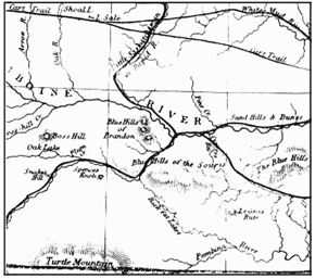
The
region
as Hind saw it
in 1858.
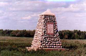
A
cairn
erected at the
site of Brandon House #4
Sources:
Brown, Mrs. A.E. , The Fur Trade Posts of the Souris-Mouth Area, The
Historical and Scientific Society of Manitoba Papers Series III
Brown, Roy, The Brandon Hill Connection, Tourism Unlimited, Brandon Mb
Brown, Roy, The Fort Brandon Story, Tourism Unlimited, 158 8th St.
Brandon Mb
Clarke, Lawrence, B. Souris Valley Plains: A History , Souris
Plaindealer, Souris Mb.
Mackie, H., Pine Fort: A Preliminary Report , Manitoba Museum of Man
and Nature, 1972
McMorran, Souris River Posts, Souris Plaindealer, 1950
Kavanagh, Martin, The Assiniboine Basin, The Gresham Press, Old Woking,
Surrey, England
Welsted, John, Everitt, John, And Stadel, Christoph : The Geography of
Manitoba : Its Land and People. University of Manitoba Press
|
|
|