by John L. Tyman
Department of Geography, Brandon University
MHS Transactions, Series 3, Number 28, 1971-72 Season
|
In 1870, with a stroke of the pen, our fledgling dominion assumed responsibility for a vast inland empire. The surrender of Rupert’s Land and the North West Territories by the Hudson’s Bay Company vested in the federal government ownership of a public domain with an area five times the previous size of the entire Dominion. Much of this land, admittedly, was manifestly unsuited to settlement, but tucked away in the west were lands which some people at least considered a veritable Garden of Eden.
The natural resources of this vast area, from 1870 onwards, were the property of the federal government; and they remained so until 1930. Initially, the administration of this public domain was the responsibility of the Secretary of State, but in 1873 the Department of the Interior was established and assigned all matters pertaining to lands.
My concern is with the Dominion Lands Era. This began with the passage of the Manitoba Act in 1870 - which provided that “all ungranted or waste lands” should be “administered by the Government of Canada” and ended with the transfer of natural resources to the provinces in 1930. And what I would like to do is consider the ways in which the Government of Canada went about the task of organizing its inland empire-examining both the theory and the practice of western land grants. In so doing I shall use Western Manitoba as a sort of case study, illustrative of settlement in the prairies generally.
Grants of 200 acres were proposed initially, but the American pattern was adhered to in the Order in Council of April 25th, 1871 - the first real statement of “Dominion Lands” Policy. Any person who was the head of a family, or a single man 21 years of age, would be entitled from May 1st, 1871 to enter for a quarter section of 160 acres. This land would be patented to the settler (or his widow) “upon proof, to the satisfaction of the Land Officer that he ... resided upon or cultivated the land for the three years next after the filing of the affidavit for entry”. These provisions were incorporated in the first Dominion Lands Act, assented to on April 14th, 1872. [1]
The “duties” required of homesteaders were redefined periodically. Originally at least six months’ residence was required during each of three years. Exceptions were made in the case of groups of not less than 20 families who, “with a view to greater convenience in the establishment of schools and churches, and to the attainment of social advantages of like character”, wished to settle together in a hamlet or village. In such cases the Minister might “vary or dispense with the ... requirements as to residence, but not as to the cultivation of each separate quarter section”. [2]
In 1884, however, the desire of the government for settlement at any price found expression in alternative and more liberal provisions. Thereafter homestead duties could be performed in any of three ways:
Subsequent Orders in Council also specified the acreage to be cultivated by persons perfecting their entries in the normal way. At least 15 acres had to be broken and ten cropped.
New regulations were issued in 1908. Those in residence were now required to break at least 30 acres, of which 20 should be cropped, before applying for patent. Persons resident “in the vicinity” would have to break 50 acres and crop 30. Adjustments were made, though, in the case of homesteaders “unable to fully meet the requirements by reason of woods, rock, or the broken character of the surface”. [5] If a report from a Homestead Inspector showed that a quarter section did not contain “arable land to the extent required to obtain patent under the regulations” authority would be granted to the entrant to offer livestock in place of breaking and seeding.
Originally a settler could homestead any unappropriated public lands: whether the quarter he desired was part of an odd or of an even numbered section was of no consequence. This all changed in 1879 when the Commons approved the appropriation of 100 million acres for railway purposes. [6]
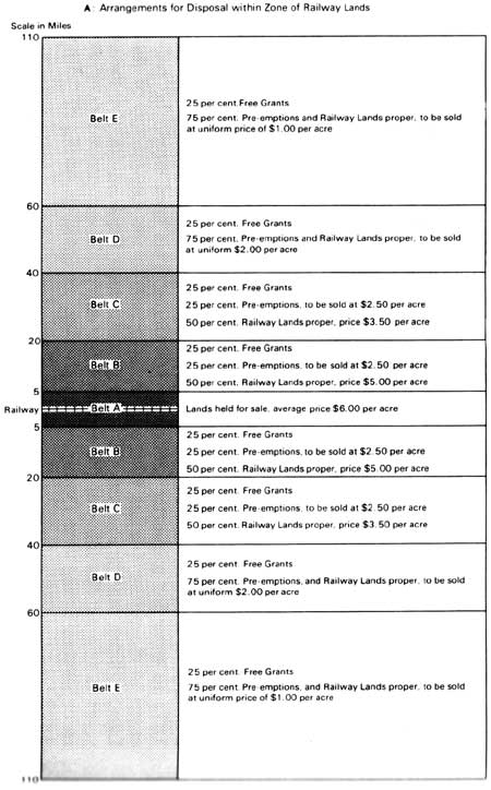
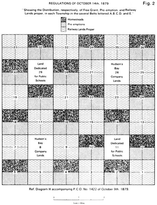
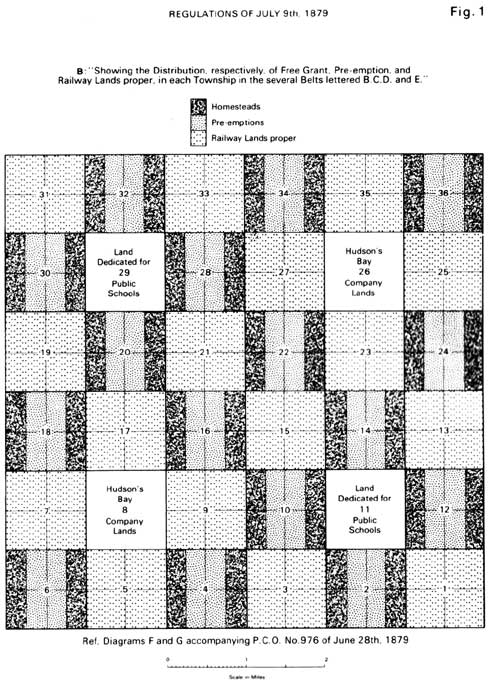
The Minister was required to specify the manner in which these lands might be “most conveniently set apart and described”, also how they could be administered to realize an average price of $2 per acre. He recommended that lands sold “within the zone ... bisected by the Railway” should all be classed as “Railway Lands”. He recognized, though, that the withdrawal of homestead privileges entirely “would not operate as advantageously as a system of free-grants to a reasonable extent, distributed throughout the Railway Belt”. Assuming the length of this zone through Manitoba and the Territories to be 1,000 miles he proposed a belt of Railway Lands extending 110 miles on either side of the line. This would provide 25 million acres for homesteads besides the area required for the CPR. Under the regulations of July 9th, 1879 lands within five miles of the railway were withdrawn from homesteading and held exclusively for sale. Free grants were, however, provided in all other townships-four homesteads of 80 acres in each even numbered section, exclusive of those allocated to the Hudson’s Bay Company (Figure 1).
Even before they were published, however, it was obvious these regulations would have to be changed. On July 3rd the Minister was warned that Congress had recently increased the size of homesteads in the United States, from 80 to 160 acres, and railway companies were now offering substantial rebates on lands cultivated inside of three years. [7]
So soon as it was known that the homesteads and [purchased] pre-emption lands had been diminished by one half [in Canada], ... and that the price of the lands was thus increased, the American agents went about and depreciated without scruple the advantages which the Canadian North-West presented for emigration. [8]
The necessary changes were authorized in October (Figure 2). The size of homesteads and preemptions was increased and the even numbered sections in Belt A were opened to entry. A price of $2.50 was set on preemptions here, matching that of Belts B and C. The price of railway sections was maintained in the case of lands 40 miles or more from the line as located, but it was reduced otherwise-from $6 to $5 in Belt A, from $5 to $4 in Belt B, and from $3.50 to $3 in Belt C. The term “Railway Land” was henceforth to be used only in reference to odd numbered sections.
Further changes were necessary in 1881 when it was decided that the transcontinental would after all be built by private enterprise, and not by the government. The CPR was awarded most of the odd numbered sections in a belt extending for 24 miles on either side of the Main Line. [9] The idea here, in theory, was to raise the subsidy of 25 million acres guaranteed the Syndicate: but if all the odd numbered sections in the 48 Mile Belt had been both available and acceptable this would still have realized only 14 million acres, not 25! The subsidy had been computed on a mileage basis, and the 48-Mile Belt, could, in theory, have supplied the acreage earned over the 1,040 miles between Winnipeg and Jasper House. The problem was that since the Dominion had no control over lands in Ontario and British Columbia, a further 11 million acres were required. As it turned out, save for just 1,300 acres on the Pacific Coast, the entire subsidy was drawn from Manitoba and the North West Territories. Had the government intended to provide the Syndicate with 25 million acres from odd numbered sections adjacent to the Main Line it should have reserved a belt 84 miles in width, not 48! (Should the missing 11 million acres, in fact, be attributed to loss of memory, miscalculation, or a typographical error?!) In consequence, and since the Company in any case did not have to accept lands which were not “fairly fit for settlement”, additional reserves were necessary-some of them far removed from the Main Line. In Western Manitoba this was reflected in the establishment of a Southern Reserve, south of the 48-Mile Belt, and of a northern one by Lake Dauphin. [10]
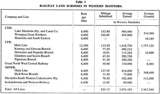
Later, smaller subsidies were approved for second class or colonization railways. Initially they were merely entitled to purchase lands, at a reduced price of $1.00 per acre. This was later changed to a free grant, and more or less standardized at 6,400 acres per mile-roughly half the rate approved for the transcontinental. [11] The belts reserved for colonization railways, in other words, were 24 miles in width. Subsidies were granted to seven such companies in Western Manitoba, and the principle was extended to cover CPR branch lines as well (Table 1).
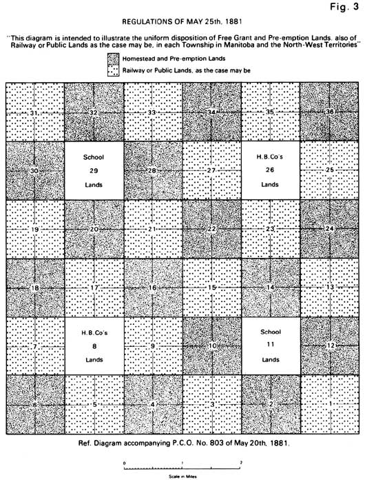
With the return to private enterprise in 1881, the regulations established in 1879 were obviously in need of revision. The CPR planned to dispose of its lands at a uniform price of $2.50 per acre, regardless of position within the 48-Mile Belt, with a rebate for cultivation. [12] The government was loath to reduce the price of Dominion Lands, but was prepared to simplify its regulations (Figure 3) in accordance with the new definition of railway lands. Within the 48-Mile Belt preemptions would cost $2.50 per acre (as before); elsewhere a uniform price of $2.00 would be charged for preemptions as well as for the odd numbered sections (now reserved for sale as public lands). The new regulations were drafted on May 18th, authorized by the Privy Council on May 20th, published on the 25th, and came into effect immediately.
As additional (colonization) railways were proposed, yet another set of rules was issued on December 23rd. From January 1st, 1882 surveyed lands were to be assigned to one or other of four categories:
Class A
Lands within twenty-four miles of the main line or any branch line of the Canadian Pacific Railway, on either side thereof.
Class B
Lands within twelve miles, on either side, of any projected line of railway (other than the Canadian Pacific Railway).
Class C
Lands south of the main line of the Canadian Pacific Railway not included in Class A or B.
Class D
Lands other than those in classes A, B and C. [13]
The recognition given to lands in Classes B and C inevitably involved an increase in the price both of preemptions and Dominion Lands Sales, from $2.00 to $2.50 per acre.
When preemption rights were first outlined in 1871 the term was used in the American sense, signifying a claim established by residence in advance of the frontier. [14] Persons in this position could purchase the land on which they had settled, or homestead it on the usual conditions.
A distinctively Canadian view of preemption was formulated later, in 1874:
The entry of a person for a homestead right shall entitle him to receive at the same time therewith an interim entry for any adjoining quarter section then unclaimed, and such interim entry shall entitle such person to take and hold possession and cultivate the same, ... and obtaining a patent for the homestead ... to purchase the said adjoining quarter section. [15]
The privilege was abused, of course, and under the Dominion Lands Act of 1883 it should have been repealed, with effect from January 1st, 1885. This was countered by a strong lobby in the Commons, and extensions were granted in 1884 and again in 1886. [16] It was abrogated eventually, however, with effect from January 1st, 1890.
The Order in Council which introduced the term “preemption” also provided that unappropriated public lands would be available at $1.00 per acre. [17] Individual purchases were to be limited to one section, but it was easy to avoid this tiresome restriction by the thoroughly legal process of “assignment of rights”. An enterprising young capitalist wishing to purchase a large acreage had simply to recruit a sufficient number of persons willing to file applications for 640 acres each. He could even arrange the transaction himself, as their attorney. He would later order the assignment to himself of all lands so purchased, and the acreage he had worked so skillfully to assemble would then be patented to him in a single document. [18]
Section 9 of the regulations of May 25th, 1881 provided that north of the Railway Belt “a person being an actual settler on an odd-numbered section” would “have the privilege of purchasing to the extent of 320 acres of such section”, at a price of $1.25 per acre. With this exception, though, public lands were offered for sale in the eighteen eighties with no restriction as to size of purchase. Indeed, in 1882 the Dominion Lands offices at Winnipeg, Gladstone, Little Saskatchewan, and Birtle were instructed to offer for sale all odd-numbered sections of Dominion lands still vacant in their respective districts. [19] And as there was every chance of “the pressure of intending purchasers ... being such as to interfere with the due conducting of business”, agents were empowered to auction lands at an upset price of $2.50 per acre, cash. [20] Thousands of acres were disposed of in this way in the space of a few days, and for appreciably more than the minimum proposed. The sale at Birtle alone realized over $700,000. [21]
The allocation of a grant for educational purposes was forecast at the beginning of the Dominion Lands era. The original memorandum of Alexander Campbell, implemented by Council in April of 1871, made reference to “Lands reserved for Schools”. It gave no details, but the Order in Council of April 15th, 1872 authorizing the selection of “Half-Breed” reserves referred specifically to sections eleven and twenty-nine “which may be required for school purposes”. The Dominion Lands Act of that year confirmed the arrangement, “as an endowment”. [22] Many sections were never sold, however, for it was decided that they should be disposed of by public auctions and that they should be withheld from sale till they had obtained “their maximum value”. In many cases the government held out too long.
In its Deed of Surrender the Hudson’s Bay Company was awarded more than just a few trading posts. By way of compensation (and as a means of enlisting its active co-operation in the settlement of Western Canada) the Company might “at any time within fifty years after ... the said surrender, claim in any township or district ... in which land is set out for settlements, grants of land not exceeding one-twentieth part of the land so set out”. [23]
Just how this would work out in practice had yet to be decided, but the position was formalized in the Lands Act of 1872. As there were 144 quarter sections in a normal township seven would be allotted to the Company, four in section 8 and three in 26 (to complement the allocation of School Lands). Seven out of 144 represented 4.86%; the balance would be provided by allocating the Company the whole of section 26 in every fifth township (viz. townships 5, 10, 15, 20, etc.). In total, therefore, it would receive 36 quarter sections out of every 720-one twentieth of the whole.
From Figures 1-3 it will be noted that from 1879 onwards Hudson’s Bay Company sections were encircled either by railway lands or by Dominion Lands Sales, while the School sections were surrounded by lands reserved for homestead and preemption entry - at least, this was the position in theory.
Homesteads, preemptions, ordinary sales, railway lands, school lands, and Hudson’s Bay Company lands-these were the staples of Dominion Lands policy. There were, however, various minor categories of land grant.
The Order in Council of April 25th, 1871 had made provision also for special grants to ex-servicemen:
Each officer and man who is or has been in the First or Ontario, or in the Second or Quebec Battalion of Rifles, now stationed in Manitoba ... shall be entitled to a free grant, without actual residence, of one quarter section.
Subsequently, until 1877, every recruit taken for service in the garrison maintained at Winnipeg was, under the terms of his enlistment, promised a similar grant on his discharge.
In the years that followed, throughout the Dominion Lands era and beyond, successive conflicts were matched by successive grants, though as time passed and the battles grew bloodier the area from which veterans had to select their lands declined drastically, in quality as well as in quantity.
The principle was extended even to cover law officers on the frontier. Bounty grants were authorized in 1873 for members of the North West Mounted Police. [24] Warrants were issued for:
A free grant ... not exceeding one hundred and sixty acres to any Constable or Sub-Constable of the said force, who, at the expiration of three years of continuous service ... shall be certified by the Commissioner of Police to have conducted himself satisfactorily. [25]
The privilege was withdrawn in 1879, in the case of men joining the force on or after July 1st of that year.
The Rebellion of 1885 gave occasion for a third such grant. Members of the Militia who had served west of Port Arthur were offered “a free homestead of two adjoining quarter sections”, without payment of fees. [26] This time, though, grants were subject to the usual regulations in regard to the perfecting of entries and the fulfilment of residence and cultivation conditions. Persons entering for 320 acres exhausted their homestead privileges. Volunteers (but not their substitutes) who were already in possession of a free homestead grant could, however, apply land warrants in payment of preemptions obtained in the normal way. Alternatively, any person entitled to enter for 320 acres as a homestead might, in lieu thereof, receive scrip for eighty dollars.
Next came the Boer War. Under the Volunteer Bounty Act of 1908 [27] returned soldiers (and nurses) could enter for two quarter sections or accept scrip for $160. Where land was taken entry was again subject to the usual regulations, with just one modification. Residence on a (civilian) homestead entered for by the grantee or his substitute within the vicinity could not be counted in connection with a bounty grant. However, as he was in each case required to reside on the land for only six months out of every twelve he could meet the requirements for both entries if he had two houses, or one which could be moved.
Veterans of the First World War (and widows) were voted 160 acres and/or a loan. [28] In addition to his Soldier Grant, though, an ex-serviceman was free to exercise his civilian homestead right. He could also, of course, obtain land by purchase. As amended in 1919, however, the Soldier Settlement Act provided that no free grant should be made to a settler who was the owner of or had “a vested possessory interest in agricultural land of such an area” as, in the opinion of the Soldier Settlement Board, constituted “an average farm for the district”. [29] A farm of 320 acres was considered “average” for the Western Provinces.
The Manitoba Act had appropriated ungranted lands, to the extent of 1,400,000 acres, for the benefit of the families of “half-breed residents”. [30] It was to be divided among the children of the “Half-Breed” heads of families residing in the Province at the time of the transfer, allowing, so it was thought, 240 acres for each child. Four years later “Half-Breed” heads of families were themselves provided with grants of 160 acres or $160 in scrip. [31] In 1885 scrip (for $240) was issued to “Half-Breeds” in the Territories also.
Both the original allotment and subsequent issues of scrip had unfortunate effects, on the Metis people as well as on the process of settlement. [32] Since it lay outside of the province as originally constituted, Western Manitoba was spared the frustrations associated with “Half-Breed” Reserves, but the provisions made for “Half-Breeds” to the east and west were echoed here in the application of scrip by individuals who had purchased the same, usually at a fraction of its face value. Whereas assignments of military and police warrants had to be endorsed and properly witnessed by a J.P. or Commissioner for Oaths, dealings in “Half-Breed” scrip were spared even this formality.
The reclamation of marsh lands was authorized in 1880, against provincial funds held in trust by the Dominion and on condition that a free grant be made to the Province of Manitoba of the even numbered sections “so made available for cultivation and sale”. [33] By 1884 a quarter of a million acres had been reclaimed and 112,146 acres handed over to provincial control. [34]
The “Drainage Lands” transferred to Manitoba in 1884 lay well within the Province as originally constituted. In the following year, however, this peculiarly Manitoban feature of Dominion Lands policy was given broader application. The provincial government was in difficulty financially, and the “Better Terms” Act of 1885 provided that all Crown Lands in Manitoba which could be shown to be Swamp Lands “to the satisfaction of the Dominion Government”, would be transferred to the Province “and enure wholly to its benefit and uses”. [35] The arrangement was terminated in 1912, when the boundaries of Manitoba were extended northwards and subsidies received in lieu of lands were adjusted to match those of the newer provinces.
Swamp Lands were administered under the Provincial Lands Act which came into force on July 1st, 1887: so too were the “M&N” lands which devolved upon the Province from the grant of the Manitoba and North Western Railway. The MNWR had borrowed money from the Manitoba government in the 1880s, and when it failed to repay the amount owing (even to cover the interest on the loan) the Province assumed control of the remains of the Company’s land grant-over 500,000 acres.
Among lesser categories of grant the most important in Western Manitoba was the allocation of 150,000 acres in aid of the University of Manitoba - another of the provisions of the “Better Terms” Act of 1885. A variety of “Free Grants” and “Special Grants” were made also on a smaller scale both to individuals and corporate bodies, for services rendered or in adjustment of other transactions.
For a few years, too, beginning in 1876, grants were made to persons interested in Forest Tree Culture. [36] A person could enter for a free grant of up to 160 acres of land which was “open prairie and without timber”. He could not obtain a quarter on this basis if he already had a homestead and a preemption, but he could convert his pre-emption to a tree planting claim. Patent was to issue after six years “on proof to the satisfaction of the local Agent” that one fifth of the land had been planted with timber, and that the latter had been “regularly and well cultivated and protected from the time of planting”. The idea was to render the open prairie more hospitable “by cultivating forest trees thereon”, but little came of it, and it was abandoned in 1879.
The complexity of the legislative framework established for Prairie Settlement was, needless to say, reflected in a complex pattern of land grants - far more complex than most writers would have us imagine. [37]
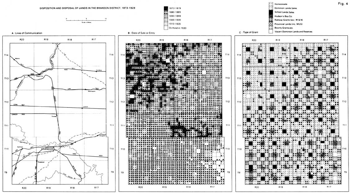
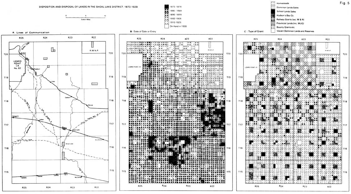
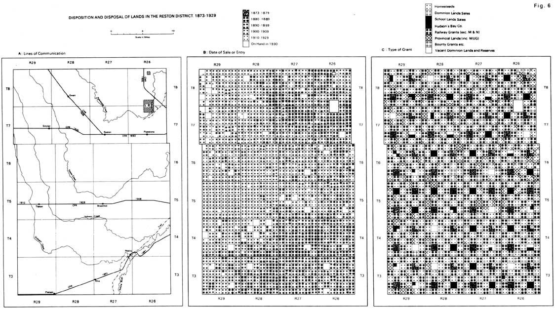
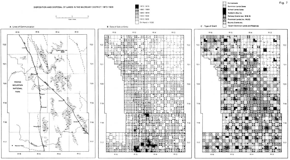
The range of patterns possible at the quarter section level is suggested in Figures 4-7, which record the actual arrangements which evolved in specified case study districts.
The Brandon District (Figure 4) was occupied ahead of the rest, especially lands adjacent to the Little Saskatchewan. Almost all of the available land alongside the river had been alienated by 1881 (as homesteads or preemptions), odd numbered sections as well as even. Smaller numbers of pioneers located along the Southern Branch of the Saskatchewan Trail, but those who settled in the late seventies in Townships 9 and 10 (near the Brandon Hills) do not appear in Figure B as these lands had yet to be sub-divided: in other words the early pioneers here were squatters.
During the great Manitoba Land Boom of 1881-82 a vast acreage was taken up both north and south of the transcontinental. With the exception of the School Lands endowment, which was for all intents and purposes a frozen asset then, there was really very little land available for further settlement at the close of 1882. As a result, the emphasis in succeeding decades shifted from Dominion Lands to company sales (including resales).
The eventual disposition of the land here (Figure C) is marked by a reasonable degree of regularity, but the area is notable for the large number of Dominion Lands Sales and for the disruption of the Main Line Land Grant by the early entries adjacent to the Little Saskatchewan and on the trail to Grand Valley (forerunner of Brandon). The effects of squatting north of the Brandon Hills are also noticeable, together with departures from the normal arrangement of School and Hudson’s Bay Company sections. The delayed occupancy of the coarser, sandy soils southeast of the city allowed for the selection of several quarters by the University of Manitoba.
The Shoal Lake District (Figure 5) was also the scene of much early activity, in the seventies as well as the eighties; but there were notable differences. For one thing the acreage disposed of here under Dominion Lands Sales was substantially in excess of that homesteaded. The Brandon District lay almost entirely within the Main Line Belt, the Shoal Lake District outside it.
The Saskatchewan Trail provided ready means of access to the southern half of the area. Lands disposed of in the early years were mostly concentrated by Shoal Lake, at the junction of the trails, but a large acreage was taken up later adjacent to the route proposed for the transcontinental in 1879-80.
Many of the odd numbered sections were sold in April of 1882 under the emergency regulations then in force. Such sales were, however, restricted to Townships 15 and 16, and the southern half of Township 17 in Ranges 24 and 25 - seemingly in anticipation of the reservation for the Portage, Westbourne and North Western Railway (later the MNWR).
A further period of activity was generated by the wheat bonanza in the early years of the twentieth century and, locally, by the construction of the Canadian Northern line. Hitherto the wooded and stony end moraines of the northern two tiers of townships had been avoided, though subdivided prior to the Boom of 1881-82.
The apportionment of lands here (Figure C) displays a greater range of variation than that of the Brandon District, with obvious differences between sub-regions. The heavy emphasis on Dominion Lands Sales in the south contrasts with the free grants which prevail in the later-settled areas of the forested north and northeast. The pattern of railway lands in the four northern tiers of townships was regular enough to begin with but was disrupted by assignment of “M&N” lands to the Province of Manitoba. The Hudson’s Bay Company received several “extra sections” in lieu of lands lost to squatters etc. elsewhere. And several School sections had yet to be alienated in 1930.
The Reston District (Figure 6). While both Brandon and Shoal Lake lay largely within the parkland belt, the Reston District lay well within the limits of the treeless prairie. It was surveyed later than most of Southwest Manitoba, and attracted little interest even during the Boom. The general absence of early settlement (squatters included) is reflected in the proportion of land granted to the Canadian Pacific and Manitoba South Western railways, in the small area alienated as Dominion Lands Sales, and in the sizeable acreage granted to the University.
In the nineties the construction of the Souris Branch in the southeast and the Pipestone Extension in the northeast encouraged settlement in these areas. The “triangle” in between remained largely vacant, however, plagued by sand in the east and by topographic and drainage problems on the heavier soils to westwards.
In the early years of the twentieth century, with the optimism of another boom and the rapid extension of the railway system, a tremendous acreage was disposed of here in the space of a few years. There were homesteads available still, but it was mainly a time for speculation in railway lands. Thereafter there was little further activity, and slightly more land remained on hand here in 1930 than in the Shoal Lake District, in spite of the latter’s location on the margin of the Riding Mountain Timber Reserve.
From the point of view of land grants the Reston district is clearly the most uniform of the four case study areas. It is dominated by a chequer board pattern of railway lands and free homesteads. The disposition of sections 8 and 26 conforms exactly with the norm for Hudson’s Bay Company lands.
The McCreary District (Figure 7) was the least hospitable. It was very heavily wooded, with no grassland to speak of, and much of it was poorly drained. It was almost all subdivided in the seventies, at a time when it seemed that the CPR would pass this way; but it was occupied only late in the day. Townships 21 and 22 in Range 13 were subdivided very much later (in 1912) and generally speaking remain vacant even today.
In the nineties settlement was extended northwards from the Big Grass River, following the trail at the foot of the escarpment, and southwards from Dauphin, along Turtle River. The impact of railways upon settlement was delayed somewhat, especially in the case of the Lake Manitoba Railway and Canal Company. At the time when this line was built the district was little more than a zone of passage, certainly not the object of any great wave of pioneer settlement.
The optimism of the wheat bonanza and the growing shortage of farm land were later expressed in large purchases of CNR and Swamp Lands, many of them manifestly speculative. And the period of active homesteading was sustained for longer here than in other case study areas. Nevertheless, a great deal of land remained on hand in 1930, in every category.
Compared with the Reston District, McCreary exhibits a complex arrangement of grants. The most distinctive features of this area are the extent of (a) Swamp Lands and (b) Dominion Lands vacant in 1930. Railway grants are concentrated in those areas which were reasonably well drained at the foot of the escarpment. Homesteads here correlate mostly with even numbered sections but dominate overall on the slopes of Riding Mountain and in the more recently settled tract in the east. In theory the distribution of Swamp Lands was not tied to particular sections but their arrangement here is clearly biased towards even numbers. The restriction of Provincial Lands to alternate sections in Township 17 of Range 16 is explained by the inclusion of this township within the area reserved for the Manitoba and North Western Railway. Dominion Lands Sales are conspicuous by their absence and School Lands Sales are few and far between. The pattern of Hudson’s Bay Company grants is regular enough but much of this land remained unsold in 1930.
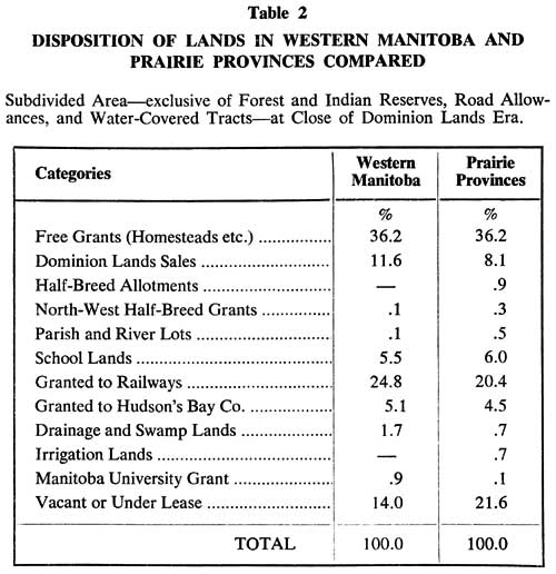
In Conclusion, the breakdown by type of grant, in Western Manitoba and the Prairies generally, is detailed in Table 2. The individuality of this region, when compared with the figures for the three provinces combined, can easily be explained in terms of historical succession and the facts of physical geography. Swamp Lands and the University grant were unique to Manitoba, and irrigation alien to the province. River lots and “Half Breed” lands were concentrated mostly in the Red River Valley. The greater emphasis on Dominion Lands Sales in Western Manitoba is a consequence of its early settlement.
In short, while the details of the components which comprise the mosaic of land grants on the Prairies may vary between regions, the pattern is everywhere complex.
1. Statutes of Canada, 35 Vie., c.23. (These are cited hereafter as Stat. Can.)
2. Quoted by Charles Cliffe, Manitoba and the Canadian Northwest as a Field for Settlement (Brandon: Mail Steam Book & Job Printing Establishment, 1884), p. 51.
3. Quoted by C.W. Allen, The Land Prospector’s Manual and Field-Book (5th ed.; Ottawa: Queen’s Printer, 1889), p. 29.
5. Department of the Interior, Dominion Lands Hand-Book (Ottawa, 1915), p. 18.
6. Commons Debates, 1879, pp. 1895-96. For a fuller discussion of these and other provisions for western land grants see John L. Tyman, “Prairie Settlement: the Legislative Framework”, in Southern Prairies: Background Papers ed. by A. H. Paul and E. H. Dale (Regina: University of Saskatchewan, for the 22nd International Geographical Congress, 1972), pp. 47-76.
7. Memo from Dennis, accompanying Privy Council Order of October 9th, 1879. (These are cited hereafter as P.C.O.)
8. Elie Tasse, The North West (Ottawa: Le Canada, 1880), p. 25.
9. Stat. Can., 44 Vic. (1881), c.l.
10. See P.C.O.’s of November 3rd, 1882 and August 22nd, 1903.
12. Memo, Dennis to Minister, May 9th, 1881, in Correspondence of the Dominion Lands Branch, Public Archives of Canada, Record Group 15, Series Bla file 18909.
13. Department of the Interior, Dominion Lands Regulations, December 23rd, 1881, s.1.
15. Department of the Interior, Dominion Lands in Manitoba and N.-W. Territories Open for Sale and Homestead Entry, November 4th, 1875, p. 12.
16. Stat. Can.: 46 Vie., c.17; 47 Vie., c.15; Vie., c.27.
18. For a fuller discussion of the impact of speculation upon the pattern of Dominion Lands see John L. Tyman, By Section, Township and Range (Brandon: Department of Geography, Brandon University, for the Assiniboine Historical Society, 1972), Chapter XV.
19. Canada Gazette, March 4th, 1882.
21. William Pearce, “Titles to Land in the Three Prairie Provinces” (manuscript, 1925?), p. 34. Glenbow Historical Library and Archives, Calgary. (Cited hereafter as Pearce MS.)
22. Stat. Can., 35 Vie., e.23, s.22.
24. Stat. Can., 36 Vie., c.35, s.17.
25. P.C.O., November 27th, 1876.
26. Stat. Can., 48-49 Vie. (1885), c.73.
27. Stat. Can., 7-8 Edw. VII, e.67, ss.3 and 6.
28. Stat. Can., 7-8 Geo. V, c.21, ss.4 and 5.
29. Department of the Interior, Summary of Regulations, January 2nd, 1930, p. 8.
30. Stat. Can., 33 Vic. (1870), c.3, s.31.
31. From 1876 onwards they could only obtain scrip. Stat. Can., 37 Vic. (1874), c.20; and P.C.O., March 23rd, 1876.
35. Stat. Can., 48-49 Vic., e.50.
36. Stat. Can., 39 Vic., c.19, s.21.
37. See John L. Tyman, “The Myth of the Typical Prairie Township”, Proceedings of the Great Plains - Rocky Mountain Division of the American Association of Geographers, 1971, pp. 71-77.
Page revised: 22 June 2024