by Larry Laliberte
Winnipeg, Manitoba
|
Old maps are found in the most interesting places. In the case of an 1870 map, showing the route taken by the Red River Expedition, it was folded up at the back of a 135 year old report in the University of Manitoba Archives & Special Collections. The map was uncovered as a result of research related to an Internet history project, serving as a spatial backdrop for a theme entitled Red River Rebellion. In order to liberate the folded treasure, it was carefully spread out and scanned, at which point its digital life began. A portion of the map appears on the cover of this issue of Manitoba History.
Visually, the 1870 map is a cartographic gem, meshing landscape greens with annotated reds to artistically represent the geographic knowledge of northwestern Ontario and southern Manitoba region in 1870. The map also serves as a historical snapshot of the movements, including date of arrival at each place, of over 1,400 men in the Red River Expeditionary Force, under the command of Colonel Garnet Wolseley. By combining the map’s cartographic information with other primary sources, first hand accounts, official reports, paintings, sketches and other maps and adding other data formats including audio, video, websites and Geographic Information Systems (GIS) data, all possible within the three-dimensional (3D) authoring environment of Google Earth (GE; http://earth.google.com), the 1870 map serves as a spatial portal to, as well as a representation of, certain elements of the Red River Expedition.
The first stage of re-visioning the 1870 map in GE has been the recreation of the original route of Dawson’s Road, which ran from Prince Arthur’s Landing (Thunder Bay) to Shebandowan Lake. This portion was selected because the transportation of men and materials over the road, with many sections in disarray and others not even completed, occupied approximately 60% of the Expedition’s time. Ideally, the recreation of the route of Dawson’s Road would involve the overlay of the scanned 1870 map onto GE’s satellite image data for the area and then tracing the route. However, since the original surveying methods are over a hundred years old, the route marked on the 1870 map does not line up correctly, regardless of how many times it is resized, stretched and/or rotated. Since the current highways approximate the course of the 1870 route, a GIS road data set was selected and imported into GE to serve as the base to recreate the original road.
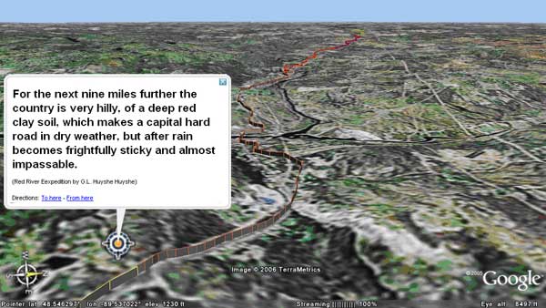
Dawson’s Road heading west towards the Matawin River as described by Captain Huyshe.
Source: Google Earth
Once the route of the 1870 road was integrated within GE’s landscape of digital elevation data and satellite images, other attributes can be added. For example, a first hand account of the state of Dawson’s Road when Colonel Wolseley arrived at Prince Arthur’s Landing on May 25th 1870, was incorporated from a book published in 1871, by Captain G. L. Huyshe entitled The Red River Expedition. In his book, Huyshe breaks down the route of the road into five segments, including the length of each segments in miles. By measuring and annotating theses segments, users can click on a portion of the route and read Huyshe’s description (see below).
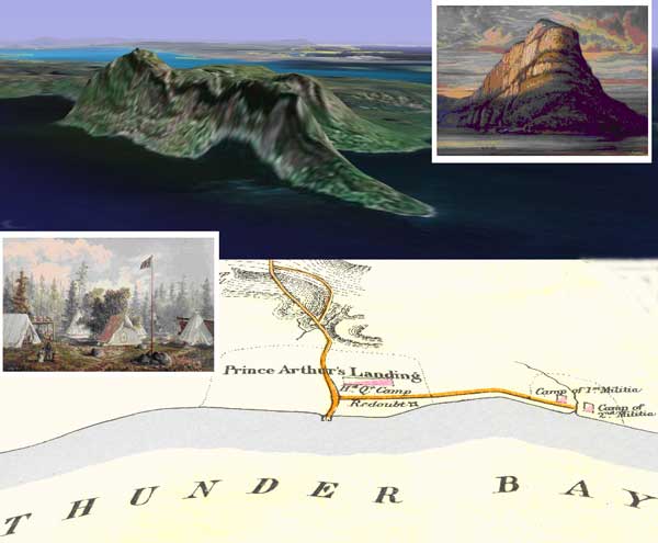
Any information that has a known location can be easily added as a place mark in GE. In virtually recreating the landscape of the 1870 map, icons have been added that link to the paintings of the Red River Expedition by William Armstrong. With a simple piece of Hypertext Markup Language (HTML) code, Armstrong’s paintings, that are available on the Internet, can be pulled into a popup balloon that is displayed when a place mark is clicked. By setting the viewing angle, a powerful feature of GE, you can simulate Armstrong’s view when he painted Thunder Cape and Colonel Wolseley’s expedition camped at Prince Arthur’s Landing (see right). These place mark techniques can also be applied to other formats, including video, for example showing the power of natural features like Kakabeka Falls, or even an audio file reminding our ears of the annoying ferocity of the mosquito.
Paintings by William Armstrong showing Thunder Cape (top) and Wolseley’s camp (bottom).
Source: Google Earth
The most promising thing about GE is the pace of development, as each month web sites and web logs (“blogs”) announce new and innovative ways to add and display information geographically. For example, further refinements of Dawson’s Road along known sections that exist today only as trails, are possible through the use of a Global Positioning System (GPS) receiver. To delineate a trail section, you would simply hike the route while a GPS collects a series of data points. Afterwards, the GPS data can be imported into GE and displayed as a new line segment, updating the original 1870 route. Google Sketch- Up is a free 3D modeling program that has been made available. With it users can design buildings and landscape features that can be imported to their real world locations in GE. For example, using William Armstrong’s painting of Wolseley’s camp at Prince Arthur’s Landing, along with a map by Huyshe showing the outlines of the camp, one could generate a 3D rendering showing the tents, barrels, redoubt, flag, and even soldiers.
The GE file for the 1870 Red River Expedition map has been placed on the MHS web site (see below) and it will be updated as more information is added to the file.
A Google Earth KML file for viewing the 1870 Wolseley Expedition Route:
View the 1870 Wolseley Expedition Route Using Google Earth
The full text of Captain G. L. Huyshe’s book The Red River Expedition in Adobe Acrobat PDF format:
See also:
Historic Sites of Manitoba: Dawson Trailhead (Southeastern Manitoba)
Page revised: 23 June 2012