by Larry Laliberte
Winnipeg, Manitoba
|
Editor’s note: Following on the article in Manitoba History 50, that dealt with a digital map of fur trade posts compiled by Andy Korsos, we hope that this present article will be the first of a series on the use of digital technology in the interpretation of historical data. Ideas for future columns on this topic are welcome.
Over the past few years there has been a growing interest in the use of historic maps within computer applications, including, standalone imaging software, Geographic Information Systems (GIS) and Internet-based visualization programs. From an imaging perspective, historic maps can be scanned at high resolutions, allowing users to zoom in and explore the margins of the map, facilitating a deeper appreciation of the textures of art, science and power in the cartographic representations of past landscapes. With the incorporation into GIS, a computer-based tool for mapping and analyzing geographic information, historical maps serve as another layer of spatial data. By integrating historical maps with current satellite imagery and other geographical data, researchers can highlight land use change over time. For example, changes to land due to water inundation by dams or loss of natural habitat due to urbanization and land cultivation for agriculture. Other GIS uses include, archaeological and architectural research, which locates historic buildings and other structures relevant to surveys and excavations and genealogical research including the location of old cemeteries. With the recent and popular release of Google Earth, a highly effective and easy to use visualization tool, historic maps can be combined with text, pictures, websites and audio or video clips to produce “mashups” that allow people to share historical material with others across the globe.
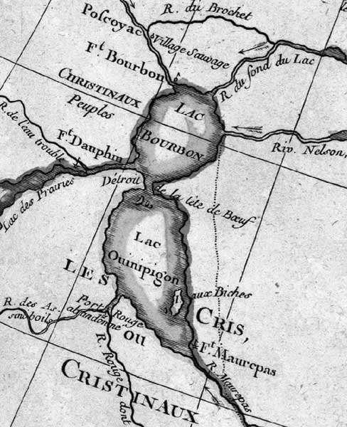
Lake Winnipeg (“Lac Ouinipigon” and “Lac Bourbon”) in Rigobert Bonne’s 1783 L’Amerique Septentrionale, from the US Library of Congress web site.
However, in order to utilize historical maps in digital form, they have to be widely available and easily accessible. Not so long ago, access meant having to personally visit the archives and libraries that housed the old maps. Recently, there has been a growth of websites with a mandate to place digital copies of historical maps online. Two of the best-known Internet resources for historic maps are the David Rumsey Collection, housing over 12,000 maps focusing on 18th and 19th century North and South America and the Library of Congress American Memory Project which offers hundreds of scanned maps as far back as the 16th century. While the web interface for each site is different, both are similar in their ease of use, allowing users to search for maps by keyword, year and geographic location, with the results displayed as thumbnail images. Once a thumbnail is selected, users can zoom into a map at a very detailed level and save and print the view. Furthermore, each map is accompanied by comprehensive metadata, including author, publisher, year of publication and other associated geographical information. One of the most important features of each website is that they provide users with the option of downloading the original highresolution map scans, for free. This is a critical point, because there are many websites that only provide the option of viewing scanned maps, often at a lower resolution. If a researcher wants access to the original scan they have to pay and wait weeks to receive the digital image, eliminating one of the strengths of the Internet, quick dissemination of, and ease of access to, information, provided you have an high speed Internet connection.
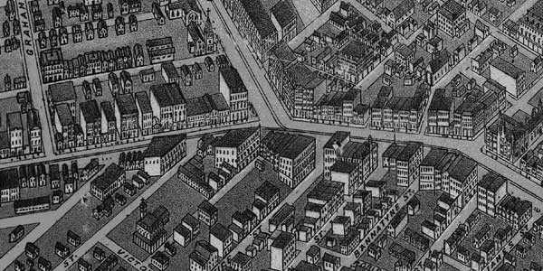
It is important to note that Manitoba content can be found on both websites. For example, a wonderful Birds Eye View of Winnipeg from 1874, which can be zoomed into at an amazing level of detail and then downloaded for use in other computer applications, is available at the Library of Congress website.
Another interesting exercise involves compiling various North American Maps dating back to 1700s, from both websites, in order to show the changing cartography and naming of Lake Winnipeg, including incarnations such as Lac des Asfenipoils, Lac Ouinipigon, and Lac Winnipeg Bourbon.
The intersection of Queen Street (aka Portage Avenue) and Main Street, from W. G. Fonseca’s 1874 Bird’s Eye View of Winnipeg, is available in digital form on the US Library of Congress web site.
While it seems ironic that individuals need to surf south of the border for Canadian cartographic content, this has unfortunately, been the norm. Yet, changes are occurring, as more Canadian based websites created by libraries and government agencies, are providing digital access to their maps. For example, ArchiviaNet allows you to search the Library and Archives of Canada’s cartographic holdings. The search results often have an accompanying image and an option for ordering high-resolution copies of the maps, for a fee and a ten-week wait! Ideally, the Library and Archives of Canada will start placing high-resolution scans of public domain maps online for direct download, similar to the efforts of the Bibliothèque Nationale du Québec, including many examples of French cartography depicting Western Canada. Currently, the best online interface, providing zooming, panning and full download capabilities, is Natural Resources Canada’s MIRAGE (Map Image Rendering DAtabase for GEoscience) website which allows users access to new and historic geological maps.
Finally, it is the goal of the eMapitoba column to highlight local projects and historical research aiming to re-visualize Manitoba’s rich spatial tapestry through innovative efforts, including, scanning and acquiring unique Manitoba maps as well as work incorporating historical maps into GIS and web based visualization software, like Google Earth.
David Rumsey Collection - www.davidrumsey.com
Library of Congress website - www.loc.gov
ArchiviaNet - www.collectionscanada.ca/archivianet
Bibliothèque Nationale du Québec - www.bnquebec.ca
Natural Resources Canada’s MIRAGE website - apps1.gdr.nrcan.gc.ca/mirage
Google Earth - earth.google.com
Page revised: 24 April 2011