by Robert W. Passfield
Parks Canada, Ottawa
Number 42, Autumn / Winter 2001-2002
|
The Red River Floodway, “Duff’s Ditch”, was constructed in 1962-68 to protect the City of Winnipeg from inundation by the Red River during years of severe flooding. The floodway channel carries floodwaters past the city and, in supplementing the flow capacity of the Red River channel at Winnipeg, precludes spring flood waters from rising to a height sufficient to overflow the river dikes and flood much of the city, including the central business district. A major public works undertaking, the Red River Floodway is representative of a Canadian tradition of governments cooperating at all levels to undertake public works engineering projects to overcome natural obstacles, and the vagaries of Nature, to establish and/or sustain the growth of communities in threatening or inhospitable environments—a tradition that embraces the construction of transportation and communications links, as well as the protection of communities from natural disasters. An engineering achievement of national import, the floodway proved its worth beyond dispute during the “Flood of the Century” in 1997.*
Metropolitan Winnipeg (660,000 population), is located 60 miles upstream of Lake Winnipeg in the basin of a former Pleistocene glacial lake, Lake Agassiz, that once covered much of southern Manitoba. The basin of the lake is one of the flattest areas in North America, and slopes gradually northwards from North Dakota with a slight descent of only 6 inches per mile on its Manitoba section. It is drained by the Red River, which originates near Wahpeton, North Dakota, and flows northward in a twisting course for 550 river miles to Lake Winnipeg across the shallow depression of the southern Manitoba landscape. A rich organic soil overlies the bed of the basin. It consists of a thick deposit of silt and a highly plastic heavy clay, or “Manitoba gumbo”, that does not absorb a high amount of rainfall. [1] Up to 50% of the precipitation falling in the Red River Valley runs off into the river system as opposed to a rainfall run off of only 10% to 25% on the sandier soils in western Manitoba. [2]
The Red River drains a large area of over 48,000 square miles (of which 38,000 are in the United States), and follows a very meandering course in flowing northward. The water flows with a slow current through a channel that varies from 200 to 500 feet in width, and has an average depth at the banks-full stage of from 10 to 30 feet. At Winnipeg the river channel is about 330 feet in width, and approximately 30 feet in depth at the banks-full stage. In summer there is about a 10 foot depth of water in the channel.
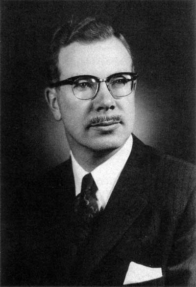
Duff Roblin, 1957
Source: Archives of Manitoba
In passing through a relatively flat terrain the river has not cut a very deep path and, in the absence of secondary banks, flood waters can easily overflow the river channel and inundate a wide area of the flat topography of the Red River Valley. In most years flooding is not a problem. The climate is such that, under the normal weather pattern, most of the precipitation falls in the summer, the winters are comparatively dry, and the spring run off does not produce overflow conditions. However, on occasion the weather pattern changes, and the climatic conditions and topography of the region combine to produce a major inundation. Conditions of extreme flooding are produced by a combination of factors: a rainy autumn followed by a severe early frost, a winter of very heavy snow accumulation, and a late spring thaw, exacerbated by a prolonged rainfall over the entire drainage basin during the spring break-up. [3]
The Assiniboine River originates in south-central Saskatchewan 430 miles west of Winnipeg. It flows into the Red River at the Forks in downtown Winnipeg, but is generally not a major factor in the flooding of the Red River. Although the Assiniboine River drains a twenty-five percent larger area (60,000 square miles) than the Red River, and on approaching Winnipeg flows through the same terrain with low banks easily subject to overflowing in time of flood, most of its basin lies within a drier climatic region. Under normal conditions, it contributes only twenty percent of the water flowing through Winnipeg, and in most years the peak spring level of the Assiniboine River does not coincide with the crest of the Red River flood. [4]
Since the earliest recorded time, weather conditions have been such that flood waters have inundated significant portions of the upper Red River Valley south of Winnipeg about once every ten years; and prior to the twentieth century, extraordinary weather conditions produced massive flooding that inundated the site of Winnipeg on average about three times in a century. [5] During the first half of the twentieth century there was little threat of serious flooding until the onset of the great Winnipeg Flood of 1950. More recently, since the construction of the floodway, the Winnipeg site have been threatened by severe flooding on a more frequent cycle.
During the 150-years prior to the construction of the Red River Floodway, the site of present-day Winnipeg was subject to severe flooding on a cyclical pattern. The site suffered a devastating high-water flood on three separate occasions during its recorded history, and experienced a partial inundation with flood waters of lesser impact on an average of once every ten years. The highest recorded flood occurred in May 1826 when flood waters rose to a height of 36.5 feet above the winter ice level in the river, and covered the site of the future city of Winnipeg in up to 15 feet of water. At its crest on May 22nd the 1826 flood created a 25-mile wide lake, inundating 900 square miles of southern Manitoba. The 1826 flood was followed by a major inundation in 1852, when flood waters rose 34.5 feet at the Winnipeg site; and in 1861 when flood waters rose within two feet of the 1852 flood levels. [6]
Lesser floods inundated upper Red River Valley towns and farmlands in 1882, 1904, and 1916, but Winnipeg emerged relatively unscathed. By 1916 Winnipeg had a population of 163,000, and was the third largest city and fourth largest manufacturing centre in Canada. It was a critical link in the east-west rail transportation and communication systems, the metropolitan centre for western Canada, and was widely regarded as the “Chicago of the North” for its rapid pace of development. With the immense floods of 1826, 1852, and 1861 fading from memory, new residential neighbourhoods were built along the river, and the city remained all but unprotected from flood waters. Moreover, for over thirty years thereafter weather conditions were never such as to produce any serious flooding along the Red River as the city continued to grow unimpeded by the river. Then in 1948 an extensive area of the upper Red River Valley was inundated once again with flood waters, forcing the evacuation of several towns, and awakening concerns about the vulnerability of Winnipeg to floodwaters. [7]
When the great Winnipeg Flood of 1950 struck, Winnipeg had not experienced a major inundation for almost a century, and remained virtually unprotected from rising flood waters. Historically severe flooding was caused by a pattern of abnormal weather conditions that recurred infrequently, but did so in the winter of 1949-50. At the height of the flood over 10,500 homes were inundated in Winnipeg, some in waters up to 15 feet deep in low-lying areas, as water covered almost one-tenth of the city. Over 100,000 people were forced to evacuate their homes in the greatest mass exodus in Canadian history.
The flood waters had a maximum flow of 108,000 cubic feet per second, and rose 30.3 feet, forming a lake 75 miles long by 24 miles wide south of Winnipeg. Over 560 square miles of southern Manitoba were inundated with water forcing the evacuation of thousands of rural dwellers from their farms and communities to the south. [8] For 51 days the river remained above flood stage, and for ten critical days the flood waters were within 1.3 feet of overtopping the sandbag dikes and flooding the whole of downtown Winnipeg. [9]
Although Winnipeg’s downtown ultimately escaped flooding, the impact of the 1950 Winnipeg Flood was such that it constituted “one of the greatest natural disasters in Canadian history.” Moreover, it was the “most catastrophic ever seen in Canada,” to that date, in terms of the extent of the flood damage, the number of persons dislocated, and its economic impact. [10] Over $22 million dollars was expended by the Manitoba Flood Relief Fund to aid flood victims; [11] and a total of $125.89 million was spent in dealing with the flood damage ($553.5 million in 1991 dollars). [12]
Shocked by the severity of the flood damage, the magnitude of the population dislocations, and the high costs of the 1950 flood, the federal and provincial governments, which had hitherto regarded flooding as a purely local problem to be addressed by the affected municipalities, experienced a dramatic change of attitude. The Winnipeg Flood of 1950 was clearly a national disaster, and the potential existed for an even greater disaster occurring in future. Thus a federal-provincial agreement was concluded providing for the federal government to pay 75% of a projected $5 million outlay to build dikes along the Red and Assiniboine rivers to protect the city from flooding, and to construct pumping stations to lift sewage over the dikes thereby preventing sewer backup. As early as July 8, 1950, the Province established the Greater Winnipeg Dyking Board to construct 30 miles of elevated boulevard dikes along the rivers within the city, and 22 pumping stations. Work commenced on September 30th, and in but 44 days over one million cubic yards of earth were moved to complete the planned diking system. The dikes, most of which were designed as paved roads, were raised to a height of 26.5 feet, about 4 feet below the 1950 flood level, but were capable of being raised to the 1950 level in an emergency. [13]
To ensure against a future disaster the federal Department of Resources and Development undertook an extensive hydrological study and analysis of past flood and run-off characteristics, and in its 1953 report (nine volumes) submitted preliminary plans for an extensive flood control system on the Red River. The study found the boulevard dikes to be inadequate in height to deal with an extraordinary flood, and dangerous should a dike be breached. Hence, it was recommended that the diking system be supplemented by excavating a 26-mile long ditch circling to the east of Winnipeg from St. Norbert to Lockport to augment the capacity of the natural river channel in carrying floodwaters through the city, and that a 25-mile long dike be built across the Red River Valley upstream of Winnipeg at Ste. Agathe to form a detention basin for retaining floodwaters. Such a system would greatly reduce the volume of water in the natural river channel during extraordinary flood years, and preclude the flood waters rising above the boulevard dikes within the city. The flood control proposals, however, would do nothing to relieve flooding in the upper Red River Valley, and indeed the Ste. Agathe reservoir would cause increased flooding there.
To further protect Winnipeg, the federal study also recommended the construction of a 17-mile long diversion channel from Portage La Prairie to Lake Manitoba to divert Assiniboine River flood waters out of the river channel 52-miles upstream of its junction with the Red River in Winnipeg; as well as a reservoir dam on the headwaters of the Assiniboine River. [14]
Fearful of the potential cost of constructing a flood control system of unprecedented magnitude, the provincial government of Premier Douglas Campbell hesitated for several years, and then appointed a provincial Royal Commission on Flood Cost-Benefit to assess the federal proposals. The Manitoba Royal Commission Report of December 1958 recommended the construction of the proposed floodway channel from St. Norbert to Lockport, with a flow capacity of 60,000 cubic feet per second, as well as the Portage Diversion with a 25,000 cubic feet per second capacity, and a reservoir dam near Russell on the headwaters of the Assiniboine River. The Commission rejected the Ste. Agathe detention basin as it would cause much of southern Manitoba to be severely flooded in a 1950 flood-level year. However, it did recommend that a feasibility and cost study be undertaken for constructing ring dikes around the rural towns in the upper Red River Valley which would still be subject to flooding.
The three recommended engineering projects would cost an estimated $72.5 million: the Floodway ($57,361,000); the Portage Diversion ($8,672,000); and the Russell Reservoir Dam ($6,450,000). However, it was believed that the provincial flood control system would protect the greater part of Winnipeg from flooding in extraordinary flood years at an estimated average annual saving of $14,099, 900 in flood damage and flood fighting costs, yielding a cost benefit ratio of 1:2.73 in construction costs versus flood costs.
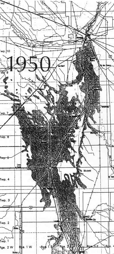
The extent of floodwater in southern Manitoba in 1950.
Source: Manitoba Department of Natural Resources
The Royal Commission calculated that the boulevard dikes (26.5 feet elevation) along the Red River within Winnipeg could contain a maximum river flow of 80,000 cubic feet per second (1.5 feet freeboard); and that the dikes in conjunction with the floodway, would be able to pass a Red River flood flow of 140,000 cubic feet per second in safety—a flow far in excess of the 108,000 cubic feet per second of the 1950 Winnipeg Flood. Moreover, when augmented by the Assiniboine River works, the proposed flood control system would be able to manage a combined Red and Assiniboine river flow of 169,000 cubic feet per second, a flood level reached about once every 165 years. [15] Nonetheless, the protection provided the city would not be absolute. The exceptional flow of the record 1826 flood (225,000 cfs), if ever repeated, would exceed the design capacity of the proposed provincial flood control system, but the costs involved in building a flood control system designed to meet an all-time record flood flow were all but prohibitive and judged not cost effective.
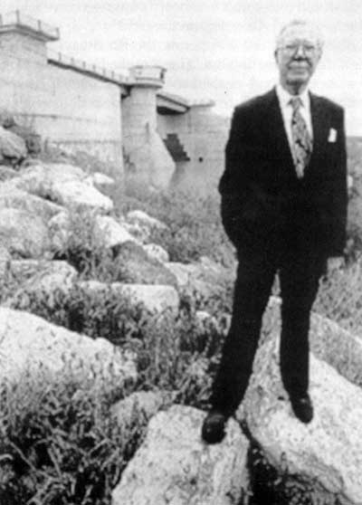
Following the submission of the Royal Commission report Manitobans were strongly divided as to whether the province could afford the capital costs of a mammoth engineering project that would benefit primarily Winnipeg. The project was championed by Dufferin (Duff) Roblin, the Leader of the Opposition and head of the Manitoba Progressive Conservative Party, but it was vehemently denounced by opponents as a monumental, and potentially ruinous, waste of money. Indeed, the projected Red River Floodway was derisively referred to as “Duff”s Folly” and “Duff’s Ditch”, and decried as “approximating the building of the pyramids of Egypt in terms of usefulness.” The construction of the floodway and Assiniboine River works, would entail a capital cost of over $72 million, amortized over fifty years at 4% interest, at a time when the province had a population of only 900,000 and an annual net provincial revenue of about $74 million.
Following the formation of a new provincial government in June 1958, Duff Roblin, the newly-elected Premier of Manitoba, continued to promote the floodway, and managed to secure a commitment from the federal government of Prime Minister John Diefenbaker to pay up to 60% of the construction costs. A Federal-Provincial Agreement was signed, and the Manitoba government announced that it would build the provincial flood control systems under the direction of George Hutton, the provincial Minister of Agriculture and Conservation. [16] Subsequently a Red River Floodway Advisory Board was established, under the Water Control and Conservation Branch, Manitoba Department of Agriculture and Conservation, to oversee the planning and design development of the floodway and to supervise its construction. [17]
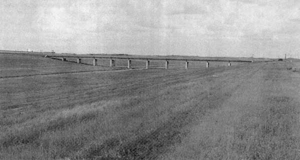
Planning proceeded immediately in routing the floodway, assembling the lands required for a 2000 foot wide right-of-way, and in designing the components of the floodway: an Inlet Control Structure on the Red River adjacent to the entrance to the floodway; the Floodway Channel; and an Outlet Control Structure in the floodway channel at its junction with the Red River at Lockport. The major concerns were the unprecedented magnitude of the required excavation, the need to schedule the work so as to avoid or minimize any disruption of transportation, communications, and utilities facilities crossing the floodway channel, and the need for a soil mechanics studies of the Manitoba gumbo to aid in establishing the optimum side slopes, cross-section, and gradient for the floodway channel. The Inlet and Outlet structures were designed by H. G. Acres & Company Ltd., Consulting Engineers, Niagara Falls, Ontario, based on model studies conducted at the University of Manitoba under the supervision of H. G. Acres & Company and the Water Control and Conservation Branch, respectively. [18]
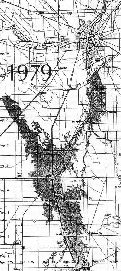
The extent of floodwater in southern Manitoba in 1979.
Source: Manitoba Department of Natural Resources
Although the floodway would pass through farm lands to the east of Winnipeg, rather than through more densely populated urban areas, nonetheless, hundreds of properties still had to be expropriated in whole or in part for its construction. Indeed, the number of expropriations was particularly large on the northern section of the floodway right-of-way in the parishes of St. Andrews and St. Pauls, where the planned channel cut across the closely-spaced farms typical of the older French land tenure system in ranging back from narrow river fronts on the Red River. [19]
In designing the floodway channel, the key concerns were: to determine the side slopes that would have long term stability in the local soils; to ascertain the maximum velocity of water flow allowable to preclude erosion of the floodway banks; and to select the most economical cross-section and gradient for a floodway channel capable of carrying the desired design flood flow within the allowable velocity limit.
Soil mechanics studies were undertaken in examining the slopes of natural river banks in the area, and excavating trenches to conduct field stability studies of the slopes. For most of the floodway route the soil was a highly plastic lacustrine clay underlain by glacial till, with the exception of one section of high ground at Bird’s Hill ridge, which consisted of a granular fluvio-glacial deposit. As a result of the soil stability studies, the floodway was designed to have a 6:1 side slope (horizontal to vertical), increasing in steepness to 3:1 in the 67 feet deep cut through the high ridge at Bird’s Hill, and flattening out to 9:1 near structures crossing the floodway to prevent turbulence and any constriction in water flow, with transitional sections of varying slopes in between.
From earlier studies it was known that the plastic lacustrine clays of the Red River Valley would not suffer from water erosion at velocities under 5 feet per second, and at such a low velocity erosion was not expected to be severe in the non-cemented glacial till near Bird’s Hill. Hence, the design of the floodway channel was based on a determination of the maximum drop and most economical cross-section that could be excavated to carry a maximum design flood flow of 60,000 cubic feet per second with a velocity feet in total over its whole 29.4 mile length to ensure that water velocity in time of flood would not exceed the safe limit of 5 feet per second; and to obtain the required flow capacity, a wide shallow channel rather than a deep narrow channel cross-section, was chosen to save on excavation costs. [20] Further protection of the floodway channel banks was to be provided through growing legume-based hay on the embankments and berms of the floodway. [21]
The Red River Floodway system was designed to handle a flood of 140,000 cubic feet per second divided between the river and the floodway, with the floodway channel having a design capacity of 60,000 cubic feet per second, and the river channel having a capacity to carry a maximum flow of 80,000 cubic feet per second safety between the boulevard dikes in Winnipeg. The basic operating principle of the Red River Floodway was one of regulated balance. The two submerged hydraulic gates in the Inlet Control Structure were to be raised during years of extraordinarily heavy flooding to a height sufficient to divert into the floodway channel any and all floodwater in excess of the capacity of the diked river channel in Winnipeg; and yet not high enough to cause a backwater effect. Any back up of floodwaters in the river above the Inlet Control Structure would raise the natural level of the floodwaters, and increase the extent of flooding and property destruction in the Red River Valley upstream of Winnipeg.
The floodway was not intended to be activated in years of minimal river flow. In years of moderate flooding, the floodgates would be operated only when the river flow reached at least 30,000 cubic feet per second, and would be set at a height sufficient to divide the flow of floodwaters between the river and floodway channels. In high flood years, the critical factor was to need to ensure that the flood waters flowing through the Inlet Control Structure, into the river channel, did not exceed 80,000 cubic feet per second, so as to leave 1.5 feet of freeboard on the primary river dikes within the city. [22]
After three years of planning, contracts for the excavation work were let on competitive bid to Manitoba contractors, and in October 1962 work commenced on a five-year project scheduled for completion in 1967. It would require the excavation of 100 million cubic yards of earth to form a ditch 29.4 miles long, 700 to 1,000 feet wide at ground level, and ranging in depth from 30 to 40 feet. To minimize disruptions, the new bridges required (7 railway and 5 highway structures) were built in situ in advance of the full channel excavation; and natural gas and oil pipelines, water lines, six hydro-electric transmission lines, and Manitoba Telephone System lines were relocated in crossing the floodway corridor, as work proceeded in lowering two branches of the Shoal Lake Aqueduct to pass under the new floodway channel. A syphon was also constructed to carry the Seine River, a tributary of the Red River, under the floodway channel.
Construction work continued almost year-round on the floodway project, with the exception of the compacting work which was suspended during the winter months. The excavation of the floodway channel proceeded in the dry with the spoil being used to build up the berms along each side. No serious water problems were encountered with the exception of rain, which made the clay extremely slippery and very hard to excavate, although sump holes and pumps were used to drain the excavation as construction proceeded. Over 50 large rubber-tired scrapers were eventually used on the project as they proved much more manoeuvrable, and less apt to get bogged down in the Manitoba gumbo, than earthmovers with tracks. Only the Inlet Structure had to be built in the river bed. The work site was dewatered through constructing coffer dams and a temporary diversion channel to carry the flow of the Red River around the worksite. The Outlet Structure was built in the dry in the Floodway Channel excavation.
The earthmoving and excavation work for the floodway was carried out by Manitoban companies. [23] The Inlet Control Structure was built, under a joint contract, by the Northern Construction Company and J. W. Steward Limited, both of Vancouver, and Bird Construction Limited of Winnipeg. Bird Construction also built the Outlet Control Structure. The steelwork of the 320 ton sector gates and the hydraulic operating pistons, were fabricated by Horton Steel Works of Toronto at their Fort Erie plant. [24]
The Red River Floodway was completed on schedule in March 1968 at a cost of $62.7 million. It was constructed by the Province of Manitoba, but financed as a joint federal-provincial initiative with the federal government contributing 60% of the total cost, or $37 million, and the province $25.7 million. [25]
While the floodway was under construction, ring dikes were constructed (1966-1972) around seven towns in the upper Red River Valley: Emerson, Letellier, Dominion City, St. Jean Baptiste, Morris, Rosenort, and St. Adolphe. A total of $9.3 million was expended on these diking operations, of which $5.5 million was contributed by the federal government under the federal-provincial agreement. [26] Construction also proceeded on the Assiniboine River components of the provincial flood control system: the Portage Diversion (built 1965-1970); and a reservoir dam at Shellmouth (1968-72) on the upper Assiniboine River. [27]
On completion, the Red River Floodway was by far the largest excavation project undertaken in Canada to that date, and one of the largest man-made channels anywhere. The volume of material excavated in constructing the floodway was close to 40% of the total excavated in constructing the Panama Canal, and exceeded slightly the total volume of material dredged and excavated in cutting the original Suez Canal channel. [28] The 100 million cubic yards of excavation for the floodway also exceeded by 36% the total amount of material excavated and dredged in building the Canadian section of the St. Lawrence Seaway. [29] Moreover, the Red River Floodway excavation dwarfed one of Canada’s hitherto largest earth-moving construction projects, the South Saskatchewan River Dam project (1960-65) which saw over 45 million cubic yards of material moved to construct two earth-fill dams, the South Saskatchewan River Dam (210 feet height, 16,700 feet crest length) and the Qu’Appelle Valley Dam (90 feet height, 9,000 feet crest length), to form an 8 million acre-foot water reservoir. [30]
The Red River Floodway was the largest excavation project in Canadian history to that date, but it was completed using existing heavy construction equipment employed in a conventional manner. No technological innovations were made in construction equipment, or construction methods, nor were there any innovations in the design of the functional components of the floodway. Indeed, none were needed in constructing the mammoth engineering project. [31]
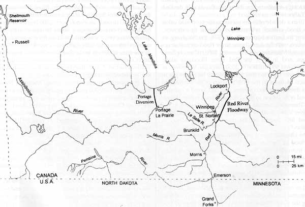
Map of the Red River drainage area showing the Red River Floodway, Portage Diversion, and Shellmouth Reservoir.
Source: Dan Pagé, Parks Canada
No sooner was the Red River Floodway completed than it proved of even greater benefit than anticipated. The decade after 1968 saw a trend toward an increased frequency and severity of flooding with the mean annual discharge of both the Red and Assiniboine rivers exceeding, by 80% and 60% respectively, that of the period between 1915 and 1968. In 1969, 1970, 1974, and 1979, substantial flooding was experienced in the upper Red River Valley south of Winnipeg, costing millions of dollars in damage; yet Winnipeg escaped virtually unscathed with the Red River Floodway in operation. Indeed, as early as 1974 the Assiniboine River water control structures proved their worth in protecting Winnipeg from serious flooding; and thereafter, in the spring of 1979, the Red River Floodway proved beyond dispute its critical value in protecting the city from potentially severe inundations. In both years the volume of floodwaters approximated the 1950 flood, and would have devastated Winnipeg if not diverted by the flood control systems. [32]
In 1974 the entire provincial flood control system was activated to combat an extraordinary combination of circumstances that threatened to inundate Winnipeg: viz. the highly unlikely phenomenon of a high flow in the Red River coinciding with a near-record flow in the Assiniboine River, and the almost simultaneous peaking (within 24 hours) of the floodwaters in both rivers. To prevent a potentially disastrous flood, the flow of the Assiniboine was reduced by diverting waters through the Portage Diversion to Lake Manitoba and retaining waters in the Shellmouth Reservoir; and the flow of the Red River was dramatically reduced by diverting floodwaters into the Red River Floodway. Without the flood control systems, the floodwaters in Winnipeg below the junction of the Red and Assiniboine would have flowed at 96,000 cubic feet per second, and have risen to the 28.0 foot level. Uncontrolled the floodwaters of 1974 would have overtopped the primary diking system in downtown Winnipeg with disastrous results; yet with the provincial flood control system in operation, the city suffered little flood damage. [33]
The first critical test of the Red River Floodway on its own occurred in 1979 when weather conditions were such as to produce a potentially severe flooding of the Red River matching the scale of the Winnipeg Flood of 1950. With a heavy accumulation of winter snows on the ground, the valley experienced a late and rapid spring thaw followed by heavy rains during the month of April. These conditions produced a spring run-off that, if unregulated, would have raised floodwaters in the Red River at Winnipeg to the 30.1 foot level, within inches of the devastating Winnipeg Flood of 1950. Upstream of Winnipeg the floodwaters forced over 7,000 persons to evacuate their homes, and caused as much as $30 million in damages; but with the Red River Floodway in operation the floodwaters were kept under control at Winnipeg. At the height of the 1979 flood, a flow of 42,000 cubic feet per second was diverted through the Red River Floodway, while a flow of 44,800 cubic feet per second passed down the Red River channel through the Inlet Control Structure. With the floodway in operation, and the boulevard dikes, the city remained almost totally unaffected by the severe flooding in the Red River Valley to the south. [34]
Within a decade of its construction the economic value of the flood control systems was evident to everyone, including its former opponents. In 1974, the floodway, in conjunction with the Assiniboine River flood control structures, saved Manitobans an estimated $350 million in flood damages; and in 1979, the Red River Floodway alone prevented over $600 million in flood damages. Moreover, as of 1987 it was reported that the floodway had been put in operation 14 times in the first 19 years of its existence to control threatening flood waters, and had saved a cumulative total of $1 billion in flood damage costs within Winnipeg. [35] Thereafter, serious flooding was experienced in the Red River Valley south of Winnipeg in 1991, 1994, and 1996, but had little impact on the city with the floodway in operation. [36]
The ultimate test of the floodway came in 1997 when “the Flood of the Century” flowed down the Red River Valley from the United States. By that time Winnipeg had a population of 660,000 and was the eighth largest city in Canada, long-established as a major Canadian transportation, manufacturing, and metropolitan business centre. Moreover, the city had almost doubled its population and tripled its number of dwellings since the 1950 flood. As such, the potential for devastation was much greater in 1997 than during the Great Winnipeg Flood of 1950, or than in 1958 when the cost-benefit ratio of the proposed floodway was initially assessed. [37]
On April 18th, 1997, Red River floodwaters reached a record height of 54 feet at Grand Forks (population 52,000), North Dakota, and overtopped the dikes. The downtown was severely flooded, and a dozen major buildings were destroyed in fires caused by electrical sparks igniting gas escaping from ruptured natural gas lines. Over 35,000 Americans were rendered homeless by the surging Red River floodwaters as the United States government declared a state of national emergency, and forecasters predicted flooding in excess of the devastating 1950 flood. [38] Within a week, a river swollen to 18 miles in width, the biggest river in North America with a greater width and current velocity than the Mississippi River at New Orleans, flowed past the ring dike at Emerson, Manitoba, heading towards Winnipeg. Faced with a potentially disastrous inundation the provincial government declared a state of emergency, and ordered 17,000 residents evacuated from the upper Red River Valley. The federal government responded by dispatching 8,500 military personnel who worked seven days a week, around the clock, in aiding rural residents to build sandbag dikes to protect their homes and in strengthening the ring dikes around the towns of the upper valley. [39]
When Grand Forks flooded, forecasts for Manitoba indicated that the floodwaters could be high enough to back up a tributary of the Red River, the Morris River, causing it to overflow the high ground at Brunkild that separated the Morris and La Salle river basins. Such an occurrence would have disastrous consequences. Floodwaters flowing overland into the La Salle River could pass around the West Dike of the floodway, and re-enter the Red River downstream of the Inlet Control Structure at the junction of the La Salle and Red rivers. In such an event, over 2,300 homes in the St. Norbert section of Winnipeg would be immediately inundated. Moreover, it was estimated that flood waters flowing overland into the La Salle River basin would add a flow of as much as 40,000 cubic feet per second to the Red River downstream of the Inlet Control Structure, and would raise the level of the river waters a further 2 to 4 feet, thereby placing downtown Winnipeg in immediate danger of inundation.
In response to this critical threat, Manitoba Natural Resources put over 300 pieces of heavy equipment to work, 24 hours a day, in constructing a 15-mile long extension of the West Dike towards Brunkild, to prevent flood waters from flowing overland into the La Salle River Basin. In an incredibly rapid feat of construction over 900,000 cubic yards of clay and soil was moved to complete the extension of the West Dike, at an average height of 9 feet along the high ground, in but 72 hours. Four days later on April 29th the floodwaters rose against the new West Dike Extension as efforts continued to raise several threatened sections of the newly-raised embankment, and to place erosion-resistant plastic sheeting over its entire length. [40]
Efforts by authorities to forecast the river crests for the flood were complicated by a large overland flow, and record and near-record peak discharges occurring along several tributary rivers in the Red River Basin. Forecasts are based on gauge readings on the tributaries and main stem of the Red River, and on an analysis of historical data. However, the large volume of floodwater flowing overland outside of the river channels, and the record and near-record flows in the tributaries, made forecasting difficult. Indeed, during the previous two weeks forecast crest elevations were revised upwards several times as the flood waters flowed towards Winnipeg. [41]
As the floodwaters approached Winnipeg there were fears that the West Dike Extension might not hold, and serious concerns as to how the floodway system would cope with the stupendous flow of water. When the flood crested at Winnipeg on May 4th-6th the peak discharge (unregulated) of the Red River north of the Assiniboine River was 162,000 cubic feet per second, close to the maximum design capacity of the provincial flood control system. Moreover, the peak discharge on the Red River at the Inlet Control Structure, was 140,500 cubic feet per second—slightly in excess of the design capacity of the Red River Floodway system. Indeed, the 1997 flood exceeded the flow of the 1950 flood by 50%, and was the first inundation in 145 years to attain such a magnitude. Unregulated the waters of the “Flood of the Century” would have reached a height of 34.3 feet, about 8 feet higher than the primary dikes within the city.
With the flood at its crest the flow of water diverted through the floodway reached 66,000 cubic feet per second, exceeding its 60,000 cubic feet per second design capacity; and the peak flow in the river channel, passing through the Inlet Control Structure, reached 74,500 cubic feet per second, greatly exceeding the previous regulated maximum attained in 1979. However, despite fears to the contrary, the floodway proved capable of diverting sufficient waters to enable the boulevard dikes to contain the remaining river flow, and the West Dike Extension held to prevent any bypassing of the floodway system. Downtown Winnipeg was spared from a complete and devastating inundation in the “Flood of the Century”. Within Winnipeg the Assiniboine River had a negligible effect on the volume of water in the Red River owing to the operation of the flood control structures on that tributary river system. Unregulated, the Assiniboine River had an estimated peak discharge of 25,000 cubic feet per second during the height of the Red River flood of 1997, but with the Shellmouth Reservoir retaining some floodwaters and a major diversion of water through the Portage Diversion to Lake Manitoba, the flow of the Assiniboine River at Winnipeg was reduced to as low as 1,600 cubic feet per second when the Red River was at its flood crest. Indeed, at the crest of the flood the Red River waters backed up several miles into the Assiniboine River.
With the end of the flood, about May 23rd, it was evident to all that the Red River Floodway had proved its efficacy under the most extreme flood conditions imaginable. In the face of an almost unprecedented flow of water, the floodway reduced the flow of the Red River sufficiently to prevent an overtopping of the boulevard dikes within Winnipeg, and thereby saved the downtown business sector and a large area of the city from a severe inundation. [42] Moreover, the Red River Floodway was the critical element in the provincial flood control system.
Despite public fears about the capacity of the floodway system to handle the stupendous flow of rising flood waters, provincial authorities had consistently maintained as the 1997 flood approached its crest, that 99% of Winnipeg homes could be protected from flood damage. The critical concern was to raise the gates of the Inlet Control Structure sufficiently, as the flood waters rose, to ensure that no more than a maximum flow of 79,000 cubic feet per second passed through the river channel. This river flow constituted a water height of 24.5 feet, which would maintain a free-board of two feet on the lowest of the boulevard dikes within the city. [43]
Red River Floodway channel with grassed slopes.
Source: Manitoba Conservation
Although forced to operate the floodway beyond its design capacity during the “Flood of the Century”, provincial authorities had remained confident that, if need be, upwards of 100,000 cubic feet per second could be diverted through the floodway. It would have required, however, an emergency closure of openings in the berms where highway and railway bridges crossed the floodway, and/or emergency diking along the eastern Perimeter Highway to form a secondary dike to protect the city from the excess of diverted floodwaters. Moreover, the bridges crossing the floodway might have had to be removed, or blown up, to eliminate impediments to the flow of the excess floodwaters past the city. As it was, the waters backed up by the Inlet Control Structure in diverting a peak discharge of 66,000 cubic feet per second through the floodway channel, increased the flooding of farmlands outside of Winnipeg to the east of the floodway channel in the rural municipality of Ritchot, contributing to the flooding of over 125 homes at Grande Pointe.
With the floodway in operation comparatively little damage was done by the “Flood of the Century” within Winnipeg, and there was no appreciable damage from sewer backup. The pumping stations, established since the 1950 flood, pumped drainage water and sewage through the dikes, and storm sewer outlet drains were closed off. These measures thereby prevented any river backup flooding large areas of the city where a combined storm sewer and sanitary sewer system still existed. Moreover, a massive sandbag diking operation protected most of the exposed homes outside the primary dikes. As a result only thirty homes were flooded within Winnipeg in spite of dire predictions of potential devastation on the approach of an all but unprecedented flow of floodwaters. [44] However, had the floodway not been in place, and capable of functioning beyond its design capacity, the “Flood of the Century” at its peak would have inundated over two-thirds of Winnipeg, and have caused an estimated $4 billion in flood damages.
At the height of the flood a lake almost 25 miles in width extended southward from the floodway structures at St. Norbert to the American border and beyond, flooding over 256,000 hectares (632,600 acres) on both sides of the border. In Manitoba over 28,000 people were evacuated from their homes, and over one-quarter of the 3,500 farm dwellings protected by private dikes were flooded, as was the town of Ste. Agathe where an emergency ring dike failed on April 29th. However, elsewhere the ring dikes proved capable of protecting eight Manitoba towns and the Roseau River Indian Reserve from flooding. They were maintained despite several days of strong winds gusting upwards of 40 miles an hour, that drove 2 feet high waves against the dikes of the encircled towns. Hence, damages caused by the “Flood of the Century” did not exceed $400 million in the Manitoba portion of the Red River Valley; and with the floodway in operation, Winnipeg was protected from what otherwise “could have been one of the most catastrophic natural disasters in Canadian history.” [45]
Senator and former Premier, Duff Roblin with Inlet Control Structure in background.
Source: Winnipeg Free Press, 1997, with permission
Tested under severe flood conditions, the Red River Floodway silenced its critics, proved the sagacity of its proponents, and established beyond dispute the viability of the concept, the efficacy of its design, and its almost inestimable worth in cost-benefit terms. The floodway proved capable of controlling floodwaters even in excess of its design flood function, and saved the federal government, the province, the municipality, and many local property owners, a total of billions of dollars in expenditures that would otherwise have been required for emergency flood abatement, flood relief, rebuilding, and clean-ups. Although the original cost-benefit for the floodway project was estimated at 1:2.73 calculated over a fifty-year period of only emergency use during years of extraordinarily high spring floods, the floodway was in operation twenty times during the 29 years prior to 1997 to divert threatening floodwaters past Winnipeg; and in but one year of almost unprecedented flooding—during the Flood of the Century in 1997—yielded a cost-benefit ratio of roughly 1:40, a phenomenal return on construction costs.
As a construction project the Red River Floodway was by far the largest excavation project undertaken in Canada to that date, and remains so to this day. It was a construction project of national stature, and an impressive achievement in its scale of construction, planning, and organization. None-the-less, the demands of the project were typical of large-scale engineering construction projects; the machinery and equipment employed were conventional; and the floodway structures embodied known engineering principles, technologies, and materials of construction. Beyond a doubt, the Red River Floodway ranks as an outstanding engineering achievement, but its significance rests not so much in its scale, construction, or the physical properties of its structures, as in its design concept, function, and socioeconomic impact, as well as in its symbolic importance to Canadians.
The Red River Floodway has become a national symbol of what Canadian engineers and engineering works, in the tradition of public works engineering, can achieve in defending a major region of the country against the onslaught of potentially devastating natural disasters, and of the limits of what man can achieve. As expressed by the Winnipeg Free Press:
“The floodway is more than just a triumph of engineering resulting of an exemplary political vision. It is also a symbol of both our power to control the forces of nature and our impotence in the face of those elements. We can build a floodway to keep Winnipeg safe by turning the water aside, but that is all we can do. We cannot save the rest of the vulnerable areas, we cannot turn back the waters. They return almost every year to remind us of that.” [46]
As such, the Red River Floodway represents an outstanding engineering achievement, a remarkable triumph of man over the vagaries of Nature; yet one fraught with lessons as to the uncertainties involved in all such works, and the unceasing effort required to sustain them. As expressed by Senator, and former Premier, Duff Roblin, following the Flood of the Century in 1997:
“We were reminded again this year of two immutable truths: the awesome power of mother Nature and the indomitable spirit of the human family.” [47]
* The author would like to thank the Water Resources Branch, Manitoba Natural Resources, for comments on earlier drafts of a report prepared for the Historic Sites and Monuments Board of Canada (HSMBC Submission Report, 2000-05) on which this article is based. The argument expressed herein is solely the responsibility of the author, and does not necessarily reflect nor represent the views of either Manitoba Natural Resources or Parks Canada.
1. J. A. Griffiths, “The Red River Floodway”, Canadian Geographical Journal, February 1965, Vol. LXX, no. 2, pp. 42-43; and J. M. Bumsted, Floods of the Centuries: A History of Flood Disasters in the Red River Valley, 1776-1997, Winnipeg: Great Plains Publishers, c. 1997, pp. 8-9.
2. Winnipeg Free Press, A Red Sea Rising, The Flood of the Century (Winnipeg: Winnipeg Free Press, 1997), p. 4.
3. Bumsted, pp. 7-12; W. D. Hurst, The Red River Flood of 1950, Papers read before the Historical and Scientific Society of Manitoba, Series III, no. 9, Winnipeg, 1954, p. 59; and Gene Krenz & Jay Leitch, A River Runs North, Managing an International River (Red River Water Resources Council, 2nd. ed., 1998), pp. 3-8. Secondary factors such as rapid snowmelt, frozen soils, and unfavourable timing of tributary runoff, can aggravate flooding significantly, but are not essential for major flooding (Water Resources Branch, Manitoba Conservation).
4. Bumsted, p. 8; Griffiths, p. 43; and Hurst, p. 59.
5. Bumsted, p. 12.
6. Bumsted, pp. 9-20; W. F. Rannie, “The Red River Flood Control System and Recent Flood Events”, Water Resources Bulletin (American Water Resources Association), Vol. 16, no. 2, April 1980, p. 207; James A. Jackson, The Centennial History of Manitoba (Toronto: McClelland & Stewart, 1970), pp. 64-65; and Website: http//www.gov.mb.ca, Manitoba Natural Resources, Water Resources, “Facts and Figures about the Flood of the Century”. The flood heights cited at Winnipeg are the height above normal winter ice as recorded at the James Avenue Pumping Station. (The provincial government records flood levels in feet above sea level. For example, the 36.5 feet height (city datum) of the 1826 flood is recorded as 764.07 feet geodetic.) As figures vary in published sources as to the height of the 1826 flood, the figure given herein is from “Facts and Figures”, but expressed in city datum as are all other flood levels (flood stages) in keeping with the more widely used system. This is likewise the case with flood heights and flow rates cited for other flood years. Imperial measurements are used by North American hydrologists in measuring flood stages on the Red River as the metric equivalents are less useful in scale, and do not yield readily meaningful data for comparisons of flood levels and flows in the historical record.
7. Bumsted, pp. 20-49; and A. A. Den Otter, “Irrigation and Flood Control” in Building Canada: A History of Public Works (Toronto: University of Toronto Press), p. 158.
8. Hurst, pp. 63-78; Den Otter, p. 158 & 162; Weber, p. 759; and Rhonda Bruchanski, “City Prepared for Worst-Case Flood Situation”, The Metro (Winnipeg), 25 March 1997.
9. Hurst, pp. 78-79; and Thomas E. Weber, “The Red River Floodway and Related Flood Control Works”, International Conference on Water for Peace, Planning, and Developing Water Programs, Vol. 7, Washington: U.S. Government Printing Office, 1967, p. 759. The lake formed by the flood waters held an estimated 190 billion gallons, or 700,000 acre-feet of water (Ibid, p. 39). There was only a small flow in the Assiniboine River at the height of the Red River flood in 1950 (Hurst, p. 59).
10. Bumsted, pp. 71-75. The Saguenay River Flood at Chicoutimi, Quebec, in July 1996, killed seven people, forced the evacuation of 12,000 from their homes, and caused $700 million in flood damages (1996 dollars). The federal government paid 90% of the costs under federal flood-assistance programs.
12. Bruchanski, 25 March 1997.
13. Bumsted, pp. 80-82.
14. Bumsted, pp. 85-86; Weber, p. 760. The Assiniboine River did not flood during the 1950 Winnipeg Flood; however, the Assiniboine River works were intended to provide a further protection for Greater Winnipeg against the odd year when the Red and Assiniboine river floods might peak at the same time. A study of the flood characteristics of the Assiniboine River, completed by the federal Department of Agriculture, Prairie Farm Rehabilitation Administration (PFRA), was appended to the Red River study.
15. Manitoba, Royal Commission on Flood Cost-Benefit, 1958 (Winnipeg, December 1958), pp. 1-5. The Commission also recommended that the floodway entrance be moved five miles upstream (south), at a further cost of $3 million, to bring all of St. Norbert within the protected area. This was subsequently done, increasing the length of the floodway to 29.5 miles (47 km). The total flood costs saving was calculated at $700 million over a 50-year period, without accounting for any potential increase in population or price levels; and the total construction cost was calculated on a 50-year amortization period for paying off the debt at a 4% annual interest.
16. Rannie, p. 210; Jackson, The Centennial History of Manitoba, p. 250; and A Red Sea Rising, p. 19. The quote is from Jackson, p. 250. A major concern of opponents was the potential long-term debt load represented by the capital costs amortized at the then-current loan rate of 5% interest over a 50 year period. To avoid such a heavy long term debt load, the province paid its costs out of current revenues. This imposed a heavy economic burden on the province during the construction of the flood control system, but avoided a massive long term debt load (Bumsted, “Roblin’s Folly becomes Duff’s Ditch”, Winnipeg Real Estate News, 9 May 1997; and “Ditch Digger, Roblin poured careful reasoning into floodway”, Sunday Free Press (Winnipeg), 20 April 1997.).
17. Griffiths, p. 46. The head of the Advisory Board was J. A. Griffiths, Director, Water Control and Conservation Branch. The other members were: T. E. Weber of the same department; W. D. Hurst, City Engineer, Winnipeg; R.H. Clark and P. W. Strilaeff, Canada, Department of Northern Affairs; and G. W. Watson, Chief Engineer, Prairie Farm Rehabilitation Administration (PFRA),Canada, Department of Agriculture.
18. Griffiths, pp. 46-47; and Weber, pp. 762-764.
19. Manitoba Natural Resources, “Plan of Provincial Waterway and Red River Floodway”, 83-06-01, File 11-5-11068A. The central section of the floodway passed through farms surveyed in quarter mile square sections, thereby minimizing the number of expropriations required; and the southern section of the floodway for the most part ran perpendicular to the Red River through the parish of St. Norbert thereby minimizing the number of property expropriations in an area where the long, narrow, river front farms of the older French land tenure system also prevailed.
20. Weber, p. 762; Griffiths, p. 47; and J. Mishtak, “Soil Mechanics Aspects of the Red River Floodway”, Canadian Geographical Journal, Vol. I, July 1964, No. 3, Pp. 133-146. Because of the design limit on the gradient of the floodway channel, the floodway at its exit is 14 feet above the level of the Red River which dropped a total of 32 feet in passing from St. Norbert through Winnipeg to Lockport, inclusive of a 10 feet drop at the St. Andrew’s Rapids north of Winnipeg. Hence, an Outlet Structure, a combined rollway and stilling basin, was designed for the floodway channel exit to dissipate the energy of the floodwaters discharging from a 14 feet height back into the Red River.
21. Ultimately all slopes were seeded with an alfalfa-based hay mix, together with a faster growing cover crop of either rye or oats that germinates more quickly to provide shade for the slower growing hay. The usual alfalfa-based hay mix was: 12% alfalfa; 16% brome; 25% meadow fescue; 25% creeping red fescue; 16% Russina wild rye; and 6% alsike clover (Alan Skrepnek, Planning and Communications Officer, Water Resources Branch, Manitoba Conservation).
22. Weber, pp. 761-764; Griffiths, pp. 47-49; and Manitoba, “The Red River Floodway (pamphlet).
23. Steve E. Gahbauer, “Distributors enjoy equipment bonanza as Canada’s ‘Big Ditch’ gets longer”, Engineering and Contract Record (Don Mills, Ontario), November 1963, Vol. 76, no. 11, pp. 49-51. At the Bird’s Hill ridge the excavation reached 67 feet in depth. The Seine River syphon has a capacity of 100 cubic feet per second, and there is a drop structure to carry any excess flow directly into the floodway.
24. E-mail, Alan Skrepnek, Manitoba Conservation, to R. W. Passfield, 10 February 2000.
26. Bumsted, Floods of the Centuries, p. 94; e-mail, A. Skrepnek, Manitoba Natural Resources, to R. W. Passfield, 6 December 1999; and Rannie, p. 210. Ste. Agathe, which was on higher ground and unaffected by the 1950 flood, did not participate in the ring dike construction. In 1966, the federal Department of Indian Affairs and Northern Development built a ring dike around the Roseau River Reserve. Later, the Province built a ring dike around Brunkild. Subsequently, in 1983-1991, the eight municipal ring dykes were strengthened and raised to the 100-year flood level under a new federal-provincial agreement signed in March 1983. See Canada/Manitoba, Manitoba Flood Protection Projects Agreement, 1990-91 Annual Report (October 1991).
27. Weber, p. 761; and Rannie, 1980 , pp. 209-210. The Portage Diversion cost $20.5 million, and the Shellmouth Dam project $10.8 million. The federal government contributed $9.3 million and $5.4 million, respectively, towards the construction costs.
28. Gahbauer, p. 49. When opened in 1869, the Suez Canal was 100 miles long, and 20 feet deep, with a 190 feet wide channel (surface), and wider passing bays every 16 miles. Its construction involved the excavation and dredging of 97 million cubic yards of material. Almost 262 million cubic yards. of earth and rock were excavated in constructing the 51 mile-long Panama Canal. When completed in August 1914, it had a 37 feet deep channel, and 300 feet minimum surface width. (See David McCullough, The Path Between the Seas: The Creation of the Panama Canal, 1870-1914, New York: Simon & Schuster, 1977.)
29. On the Canadian section of the St. Lawrence Seaway navigation and power project (1954-1960), over 55 million cubic yards of material were excavated and a further 18 million cubic yards dredged. However, in some areas the material excavated comprised a very hard and abrasive silica sandstone (Potsdam sandstone) that almost defied removal in its unbroken form (See Eric Le Bourdais, “St. Lawrence Seaway - Part 2, Construction Aspects”, Roads and Engineering Construction (Toronto), Vol. 96, no. 11, November 1958, pp. 32-43). The St. Lawrence Seaway cost $481 million, of which Canada contributed $340 million.
30. The South Saskatchewan River reservoir (now Lake Diefenbaker) had a multiple purpose: the irrigation of over 500,000 acres of drought-prone agricultural land; the development of hydro-electric power (a potential 475 million Kwh annually); and the institution of flood control; as well as the provision of a secure water supply for urban centres, and recreational facilities for residents of central Saskatchewan. The project was designed and undertaken by the federal Prairie Farm Rehabilitation Administration (PFRA), Department of Agriculture, and constructed under a federal-provincial agreement of 25 July 1958, whereby the federal government agreed to pay 75% of the estimated $192 million construction cost of the reservoir project, and to contribute 25% of the cost of constructing the penstocks for the hydro-electric generating plant. (G. L. MacKenzie, “The South Saskatchewan River Dam”, Engineering Journal (Montreal), Vol. 43, no. 5, May 1960, pp. 50-55; and G. L. MacKenzie, “Canada’s Largest Earthfill Goes Year Round”, Engineering News-Record (New York), Vol. 165, no. 5, 4 August 1960, pp. 34-36.)
32. Rannie, pp. 207 & 211-212.
33. A. A. Warkentin, The Red River at Winnipeg (Manitoba Natural Resources, September 1999), p. 17. In 1974 the peak flow on the Assiniboine River was 32,000 cubic feet per second at Portage La Prairie of which 18,000 cubic feet per second was diverted to Lake Manitoba. Without the Portage Diversion, the Assiniboine flow would have been 26,000 cubic feet per second, the second largest on record and, at that time, well in excess of the river channel’s capacity through Winnipeg. The Shellmouth Reservoir retained only 6,000 cubic feet per second as the runoff started late from the upper Assiniboine basin. On the Red River, 37,000 cubic feet per second was diverted into the Red River Floodway. Overall, the flood control works reduced the 1974 peak stage in Winnipeg by 10.0 feet.
34. Rannie, p. 211; and Manitoba Natural Resources, Waters Resources Branch, “Facts and Figures about the Flood of the Century”. In 1976, the federal and provincial governments acted to discourage further building in the flood-prone zones outside of the boulevard dikes by withdrawing mortgage guarantees and other financial assistance programs for new private development in the high-risk areas (Rannie, p. 213).
35. Gordon Sinclair Jr., “Duff’s Ditch Top Investment”, Winnipeg Free Press, 25 July 1993, p. Al.
36. Bumsted, Floods of the Centuries, p. 102.
38. Red Sea Rising, pp . 7-13; and A. A. Warkentin, The Red River Flood of 1997 - An Overview of the Causes, Predictions, Characteristics and Effects of the Red River Flood of 1997 (Manitoba Natural Resources, July 1997). In the United States flood levels are recorded from the riverbed. Hence, the Red River floodwaters rose 54 feet above the riverbed at Grand Forks where the permanent dikes were built to a 52-foot height above the riverbed. The downtown streets were flooded to a depth of upwards of 13 feet (Maclean’s Magazine, 5 May 1997, p. 32).
39. Red Sea Rising, pp. 27-92; Bumsted, Floods of the Centuries, pp. 106-114; and “Winnipeg Rescue Hurts Towns: Report”, Globe & Mail, 15 May 1998. The floodwaters were flowing with a current of anywhere from 25 to 30 km/hour (Red Sea Rising, p. 103). On 27-28 April 1997, the Red River flowed past Emerson at 132,00 cubic feet per second. The flow of the Red River in flood, however, did not approach the average annual mean discharge of the Mississippi River (595,000 cubic feet per second) at Vicksburg, Mississippi, or the maximum discharge ever measured in the Mississippi River (2,159,000 cubic feet per second) at Arkansas City in 1937 (John R. Hardin, “Evolution of the Mississippi Valley Flood Control Plan”, Journal of the Waterways and Harbors Division (ASCE Proceedings), Vol. 83, May 1957, p. 1251-1).
40. Bumsted, Floods of the Centuries, pp. 114-115; Red Sea Rising, pp. 55-63, and 166; and Winnipeg Free Press, 27 April, p. Al, 28 April, p. Al, April 29th, p. Al, and 1 May 1997, pp. Al-A2. The southern perimeter highway formed a second line of diking, and would have protected the rest of Winnipeg north of St. Norbert from immediate overland inundation should the West Dike Extension have failed. However, at the peak of the flood it was highly unlikely that sufficient additional waters could have been diverted through the over-extended floodway to fully compensate for the additional inflow of waters into the Red River within Winnipeg from any breaching of the West Dike Extension. Hence, there was a real danger that a failure of the West Dyke Extension would have resulted in the Red River overtopping the primary dikes and flooding a large area of Winnipeg. More recently, the West Dike Extension (the so-called Z-Dike) has been partially reconstructed on an altered alignment two miles farther south as part of new highway construction work. Prior to construction of the floodway in 1962-68, its entrance was moved five miles upstream to protect St. Norbert, in keeping with the Manitoba Royal Commission recommendation of 1958. This change resulted in the La Salle River passing behind the West Dike rather than entering the Red River upstream of the West Dike of the Inlet Control Structure as intended in the original plan.
41. Red River Water Resources Council, “The 1997 Flood”, in Gene Krenz & Jay Leitch, A River Runs North, Managing an International River (Winnipeg: Red River Resources Council), 2nd. ed., 1998, addendum, p. A-4. At the Inlet Control Structure the 1997 flood would crest at 1.5 to 1.7 feet higher than the highest range forecast.
42. Manitoba Natural Resources, Water Resources Branch, “Facts and Figures”‘; and flood reports, Winnipeg Free Press, 27 April 1997, pp. A1-A3. The Red River Floodway system has a design-flood capacity of 140,000 cubic feet per second (floodway channel: 60, 000 cubic feet per second; river channel: 80,000 cubic feet per second).
43. Flood reports, Winnipeg Free Press, 25 April 1997, p. Al, and 3 May 1997, p. Al. There were 68 miles of primary dikes within the City of Winnipeg, some of which were raised temporarily, in 1997, with clay to the 28 feet level. However, other sections remained at the 26.5 feet level, as did many of the secondary dikes protecting homes along the river outside the primary diking system. The Perimeter Highway was constructed during the 1960s to a minimum road surface height of one foot above the 30.3 feet level of the 1950 Winnipeg Flood.
44. Bumsted, Floods of the Centuries, pp. 106-127; A Red Sea Rising, pp. 103- 104 & 166; Manitoba Natural Resources, “Facts and Figures”; and Globe & Mail, 15 May 1998, “Winnipeg Rescue Hurts Towns: Report”. Only two previous floods approximated the flow of the 1997 flood: the flood of 1852 (165,000 cubic feet per second); and the all-time record 1826 flood (225,000 cubic feet per second). In 1997 some 70 sewer outfalls were closed off; 35 sewage pumping stations were in operation; and many homeowners installed backflow valves and sewer plugs to prevent sewer backup into their homes.
45. Bumsted, Floods of the Centuries, pp. 117-119, & 132; Rannie, p. 213; and “Winnipeg Rescue Hurt Towns: Report”, Globe & Mail, 15 May 1998, Winnipeg Free Press, 29 April 1997, p. Al; and map of flood levels, A Red Sea Rising, pp. 96, & 123-124. The quote is from Manitoba, Natural Resources, “The Red River Floodway: The Story of One of Canada’s Biggest Excavation Projects” (pamphlet), Winnipeg, 1963. At Ste. Agathe the floodwaters breached the protective dykes from the west, or rear of the town away from the river. During the flood, City ol Winnipeg officials estimated the floodway was saving an estimated $1 billion in flood damage by diverting the floodwaters (Maclean’s Magazine, 5 May 1997, p. 32). Today, Manitoba Natural Resources estimates that the savings in flood damages in 1997 was close to $4 billion (E-mail, A. Skrepnek to R. W. Passfield, 10 February 2000).
46. “The Floods that Shape the City”, Sunday Free Press (Winnipeg), 16 March 1997.
47. Duff Roblin, Preface, Red Sea Rising, p. v.
Page revised: 14 October 2012