by Allen Ronaghan
Edmonton, Alberta
|
This paper was given by Allen Ronaghan at the Kelsey Tricentennial Conference held at The Pas from 6 to 8 July 1990. The gathering marked the 300th Anniversary of the arrival of the first European, Hudson’s Bay Company employee Henry Kelsey, in The Pas area on 10 July, 1690. The conference also focused on the role of Native people as they guided Kelsey through their homeland.
Deering’s Point is a place mentioned both in the explorer Henry Kelsey’s rhymed summary of 1690 and in the first entry of his daily journal of July to September, 1691. When The Kelsey Papers were published in 1929 historians assumed immediately that it would be useful to locate Deering’s Point. Sixty years later, however, Deering’s Point, named for Sir Edward Dering, the Deputy Governor of the Hudson’s Bay Company between 1685 and 1691, remains almost the only locality mentioned in Kelsey’s journal that cannot be identified with reasonable certainty, and it is entirely possible that it never will be identified. We do not know enough about it.
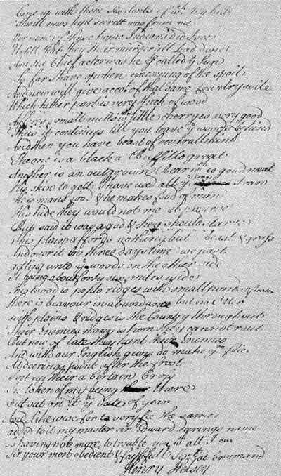
First page of Kelsey’s Journal, published in The Kelsey Papers, Public Archives of Canada, Ottawa, 1929.
The reason for this curious state of affairs is to be found in the circumstances of Kelsey’s 1690 trip inland from York Factory. Sent to “the Inland Country of Good Report” to seek out a certain tribe of Indians and persuade them to come and trade at the Bay, Kelsey found himself without writing materials. He was forced to commit to memory the important details of his trip inland, using a form of doggerel verse to assist himself. When the Indians went down to trade in 1691 Kelsey remained inland but sent a request for a notebook and writing materials. These were sent to him by the Company officials, and on 15 July, 1691, after writing down his doggerel summary of 1690, Kelsey recorded his departure from Deering’s Point. He said nothing about its location, however, and nothing in his record of the first day’s travel gives any indication of where Deering’s Point was. He wrote only that they “paddled about 18 miles and came too.”
I must point out here that entries in the journal for the following days make it clear that the Indians Kelsey was travelling with used the same route inland in 1691 that they had used in 1690. On several important occasions Kelsey made observations about a stretch of country before travelling through it. For example, his entry for 16 July records that he and the Indians with whom he was travelling “went through a little creek were we forc’d to track our Cannoes into an Island within wch is great ponds of water.” Many have recognized in this account the situation near The Pas where the Birch Creek joins the Carrot River, a short distance from where the Carrot joins the Saskatchewan. The “Island” in question is the long expanse of lake-studded country bounded by the Saskatchewan River, the Sipanok channel and the Carrot River.
Similarly, on 6 August Kelsey recorded an interesting topographical situation: “... this river breants away much to ye Southward & runneth through great part of the Cuntry & is fed by a lake wch feedeth another River wch runneth down to ye Southward of us.” This river must be the Etomami, and Kelsey must have been near the present-day town of Hudson Bay, Saskatchewan when he made his journal entry. Once known as the North Etomami, the Etomami gets its name from the fact that it rises in a lake at the “divide,” near which another river rises in a lake in the same valley and flows south. Now known as the Lilian, it joins the Assiniboine near Sturgis, Saskatchewan. In the following days Kelsey recorded his progress up the valley of the Etomami.
Later in August Kelsey and the Indians reached the open plains near present-day Preeceville and Sturgis, Saskatchewan. “This plain,” Kelsey observed, “affords Nothing but short Round sticky grass & Buffillo.” Then in succeeding days he made reference to “woods on the other side,” and, sure enough, on 27 August, they reached these woods, “ye plain being about 46 miles over.” Kelsey had reached the Beaver Hills, somewhere in the vicinity of Theodore, Saskatchewan. Readers who have studied carefully the doggerel verse of the 1690 summary will have noticed that there, too, was a reference to a plain “about forty sixe miles wide.”
These examples and others make it clear that Kelsey’s Indian friends had used the same route onto the plains in 1690 and 1691. Kelsey made enough specific references to landmarks that we can roughly reconstruct the prehistoric path to the plains which they followed: through the “island” now known as the Saskeram by canoe and setting off on foot at a point near the junction of the Sipanok channel and the Carrot River; south-westerly through “heavy mossy going” until they reached “good footing”; circling around the Pasquia hills and heading east to rendezvous with Indians near present-day Hudson Bay, Saskatchewan; south along the Etomami and Lilian rivers to reach the open prairies in the Preeceville-Sturgis area; in a southerly direction across the prairie to the Beaver Hills near Theodore; in a northerly direction to meet Indians near Fishing Lake; finally doubling back through the Beaver Hills to meet the “Naywatame poets” north-west of Yorkton. In a conversation with the Naywatame poet captain, agreement was made that the two would meet in the spring at the place which Kelsey had called Deering’s Point. Obviously there must have been something very distinctive about this location.
What do we know of Deering’s Point? Kelsey makes five references to the place, two in the rhymed summary and three in the daily journal for July-September, 1691. Only one of these references could be described as specific in any way. In his summary of 1690 Kelsey wrote:
Gott on ye borders of the Stone Indian country I took possession on the tenth instant July And for my masters I speaking for them all This neck of land I Deering’s Point did call.
I can imagine the Stone Indian leader speaking to Kelsey somewhat as follows: “This is the last portage. So far we have been travelling through the country of the Nahaythaways. From here on we are in our own country. We are at home now!”
Where might Kelsey have been told this? I think a case could be made for the ridge that lies on the old portage between Clearwater Lake and Watchi Bay of Reader Lake. It is not an eighteen-mile paddle from there to the junction of the Carrot River and the Saskatchewan, but it is precisely the type of place that Kelsey and the Naywatame poet chief could agree on as a place to meet in the spring of 1692.
One final point is worth considering in attempting to locate Deering ‘s Point. Kelsey wrote an entry in his rhymed summary that may be of interest:
At Deering’s Point after the frost
I set up their a certain cross
In token of my being thereIf Kelsey set up a cross on this ridge “on ye borders of ye Stone Indian Country,” and if he needed to build a small cairn of rocks to give added support to the cross, it is just possible that the cairn still exists. The old portage is barely visible in a fairly dense growth of brush, but it is not beyond the realm of possibility that such a cairn still remains beside this old portage trail.
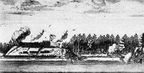
French bombardment of York Fort in 1697 from La Potherie’s Histoire de l’Amerique Septentrionale. This sketch illustrates York seven years after Henry Kelsey’s first trip inland from the post in 1690.
Source: Archives of ManitobaPage revised: 11 April 2010