MHS Transactions, Series 3, Number 28, 1971-72 season
|
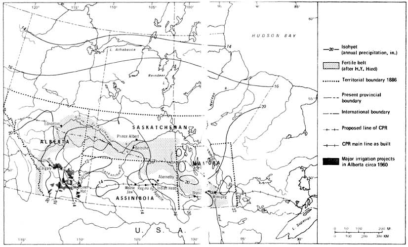
When Rupert's Land was transferred to Canada by the Hudson's Bay Company in 1869-70, the way was opened to the agricultural colonization of the vast interior grasslands and the adjacent parklands, consisting of a broad belt of meadows and aspen groves where the prairie passes into the boreal forest. Whether or not there was sufficient moisture for arable agriculture over this 800-mile wide zone of generally good soil extending from the Red river to the Rockies was a critical matter. The precipitation gradient declines ominously from 22" in eastern Manitoba to 14" and even less west of Moose Jaw and then rises again to 22" in the Foothills of Alberta (Figure 1). Erratic summer rainfall from one year to the next simply added to the perplexity of what to do with the plains; there was ample rain for crops in some years but in others there was a severe deficiency.
Mid-19th century strategic thinking on the area, based largely on two scientific exploring expeditions of the late 1850s, had suggested that there were two great contrasting zones in the interior: a Fertile Belt, extending in a great arc along the parklands from the Red river through the North Saskatchewan Country to the Foothills (Figure l), and an inhospitable extension of the so-called Great American Desert jutting across the 49th parallel into the plains where the South Saskatchewan flows. Precipitation too was low in the Fertile Belt, but since evaporation was less in those slightly higher latitudes it was adequate for agriculture. Late spring and early fall frosts could be a problem anywhere, but these hazards did not daunt the first settlers, and ultimately a variety of wheat with a shorter growing season, the famous Marquis wheat, was introduced to farmers in 1909, and largely solved the problem of a short frost-free period.
Farmers of European origin had been living at Red River since 1812, but they had little success in expanding their operations as long as they remained cut off from outside markets by poor transportation facilities. So population grew slowly. However, after 1872 when the transcontinental railroad route was planned to go through the Fertile Belt, settlers from humid eastern. Canada and Europe took up land at favoured localities in that zone all the way to Edmonton. Mixed farming proved an appropriate land use for those relatively well-endowed parklands, where moisture was more effective and wood and water conveniently close at hand, but the real test of agriculture was to come when settlers attempted to colonize the plains between the Fertile Belt and the international border. It is the innovations and defensive strategies devised for that zone. where water was a problem, which I will examine in this talk.
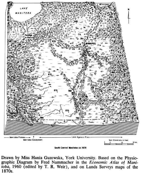
In the area close to the Red river, the difficulty was not lack of precipitation for crops, but the fact that water from the snow-melt in spring did not drain away quickly, delaying seeding and making farming impossible. The Red River Plain is one of the largest areas of flat land in North America, the bed of former glacial Lake Agassiz. From the Red, the land rises imperceptibly westward, starting at a slope of a foot and even less a mile, but gradually steepening near the Manitoba Escarpment which lies 35 to 55 miles west of the Red (Figure 2). Since the contraction of Lake Agassiz into present Lakes Winnipeg, Manitoba, and others, about 8,000 to 10,000 years ago, there has not been time for the tributaries of the Red to cut channels back across the flat lacustrine plain to connect with gullies carrying water down the Escarpment. Consequently in spring the snow-melt from the flat lands combined with the "foreign melt waters" coming down the scarp from the plateau beyond collected in vast marshes in what became a sump between the Red and the scarp. Sometimes the Red river itself floods in spring, as happened in 1826, '52, '61 and 1950, recreating former Lake Agassiz on a miniature scale in the lands adjacent to the Red. but this is a special problem which we won't deal with here.
Of concern to us is how the extremely fertile black earth soils were brought into production against such handicaps. Minor drainage work was begun in the 1840s, during the days of the Red River Colony, in an effort to drain the back swamps behind the natural levees of the Red. In the 1870s a few surface drains were dug, usually in connection with road or railroad building. In 1880, the Manitoba Department of Public Works started the attempt to drain the land between the Escarpment and the Red, by constructing a few ditches through the marshes. Accomplishments were limited, because comprehensive draining schemes extending over large areas and including many miles of lateral ditches, were what was needed, not piecemeal efforts. Consequently, in the '70s and '80s most settlers leapfrogged the poorly drained Lake Agassiz flats and moved to the higher lands above the Escarpment, except in a few townships along the 49th parallel where Mennonite settlers from South Russia established villages on somewhat higher land, though still subject to flooding.
The agricultural potential of the black earth soils was far too great to leave them as a breeding ground for mosquitoes. In 1895, the Province of Manitoba took a firm, positive stand toward rehabilitating those poorly drained areas. That year it passed "The Land Drainage Act 1895" providing for the creation of large "Drainage Districts" in order to plan and build comprehensive engineer-designed drainage systems, together with the authority to make long-term loans, backed by the government, to finance digging ditches and canals. The first Drainage District was created in 1896. By 1903, there were 13 districts, covering just over 1,000,000 acres. In 1920. they had increased to 20 districts, comprising 2,087,240 acres, with 2,552.1 miles of drains, extending over much of the southern part of the Lake Agassiz basin in Manitoba.
Large channels were excavated, connecting the marshes, into which the streams coming down the Escarpment debauched, to the short tributaries leading into the Red river. Feeder ditches led into these main drains. Significant agricultural improvements were made possible in many districts as the marshes were gradually drained. But the flooding problems were only partially solved, because the main channels all too often were clogged with snow and ice in spring when they were most needed, so that when the snow-melt from the upper watershed and the plateau entered the plugged drainage channels, the water simply spilled over and spread over the flat lands covering them once more. There the water would remain until it evaporated in late spring and early summer, delaying seeding until it was too late to put in a crop. This problem became worse as the wooded lands in the upper watershed were cleared, and as roads and ditches were built in that area, hastening the spring run off.
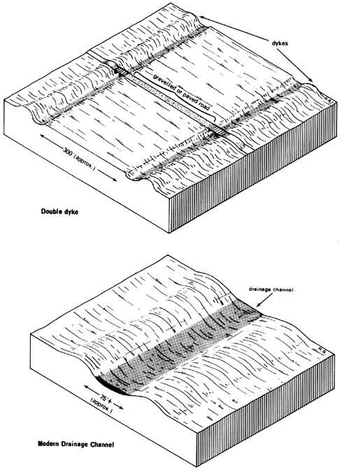
The tendency of the drainage ditches to be useless at the most critical time of the year was a technological problem solved in the second decade of the 20th century by introducing what was called the double-dyke system of drains. This scheme was referred to in at least one engineering report in 1917, but there is a record as well that farmers in one of the districts most drastically affected by "foreign water" were the first to suggest it, and that the idea was backed by them. Two parallel drainage channels were dug about 300 feet apart, with the spoil-banks heaped on the outside of each channel to form dykes (Figure 3). If the twin channels were clear of ice and snow in spring, water flowed freely within them, but if they were blocked because of special seasonal weather and run off conditions, the water spilled out of the ditches to be confined in the 300-foot wide spillway between the two dykes, thus saving thousands of acres of land beyond the dykes from flooding. The first double-dyke system was built in 1919-23, with dykes about 3½ feet high, and it helped to control flooding in 1924. The land within the spillway was used for summer pasture or haying if the flood waters did not subside soon enough to permit seeding of crops. In this way the "foreign water" from the upper watershed was controlled and conveyed across the flat lands to the Red river, so that great stretches of land could be brought safely into production.
By 1935, the surface land drainage system in southern Manitoba, consisting of 23 districts covering about 2,100,000 acres, had cost almost $7,000,000, but this investment was returned many times over by the benefits derived. Land often tripled in value after drainage, and cases are cited where its value even increased 10-fold.
Settlement had lagged significantly in the poorly drained flat areas of Manitoba, and some property, while idle, fell into the hands of speculators, often Americans, who assembled large holdings. Today this is fertile grain land. but the background of poor drainage, and its effect of retarding homesteading and substituting fewer large properties for many small farms, was evident for years in the fact that farm size on the flat lands near Winnipeg, the largest city on the prairies, was greater than that on the better drained slopes immediately below the Escarpment and on the plateau to the west.
Since World War II, great earth-moving machines have become available to dig channels, and the landscape between the Red river and the Manitoba Escarpment has changed again. Double-dyke systems proved expensive to maintain, and some have been replaced by single, very wide channels with gently sloping sides that are seeded in grass which is mowed in summer (Figure 3). These channels arc so wide that winds have a very good sweep within them and blow them clear of snow during the winter, so that they are ready to function in spring. The former lake bed, however, remains a distinctive landscape in Manitoba, with its many lesser ditches along the section roads interspersed at wide intervals by modern, spacious channels and the remaining double-dykes, all of which made farming possible on thousands of acres of fertile flat land.
Drainage is a minor problem west of the Lake Agassiz Plain and precipitation proved to be generally adequate for agriculture as far as Brandon and a little beyond. Farmers from Ontario and Britain established farms successfully in that area in the 1870s and '80s, largely following farm methods with which they were familiar.
West of Brandon, to Moose Jaw and Calgary, lies the sub-humid area where no one was quite certain whether arable farming was possible. In the 1870s, this area was still considered a desert in much of the literature, and settlers were avoiding it, preferring to settle along the route of the proposed Canadian Pacific railroad through the acclaimed Fertile Belt (Figure 1). Yet in the 1880s colonization of the southern area began, even though it was still regarded as a hazardous zone for farming. This reversal in general strategy in settlement resulted from the shift of the route of the transcontinental railroad line southward. In the spring of 1881 the newly formed Canadian Pacific Railway syndicate, which in 1880 had taken over from the government the task of constructing the transcontinental railroad, decided to build its main line directly westward from Winnipeg through the so-called desert (Figure 1).
No one has been able as yet to satisfactorily explain just why the C.P.R. route was changed to a more southerly line across the interior. Clearly, a factor such as blocking off possible United States branch railroads from across the international border was important, and, I believe, one of the main considerations was to build the line over as short a distance as possible between Winnipeg and the intended terminus on the Fraser estuary on the Pacific Ocean. Whatever the reason, the railroad was thrust through the arid zone in the early 1880s. Brandon was reached in 1881 and the Rockies in 1883, a phenomenal feat of rapid building. A land boom accompanied the construction of track, and the railroad played a great area-filling role as settlers streamed into the interior in 1881 and '82, naively following the rails into a region where no one was certain that permanent settlement based on arable farming would be possible.
In the first few years, weather conditions and crops fluctuated. There was a good crop in 1882, luring people onward, followed by poorer yields in '83, '84 and '85, because of limited precipitation in the summer months, compounded in '85 by a particularly severe early frost. Then in 1886 disaster struck; many parts of the West experienced one of the worst and most widespread droughts the region has ever had, at least since agricultural settlement began.
Even before the drought of 1886, farmers, agricultural writers and others could not escape the fact that these were new farming conditions, and that crops were not as dependable as in the humid regions they had known. There was a general realization that some adaptations in farm practices had to be made. In particular, men began to consider what ways of cultivating the land would produce the best crops, because it was soon apparent that slovenly tillage did not produce good returns. A major problem in cultivation, adding to all the other difficulties, was that all field operations had to be crammed into a short working season. In the '80s, there were debates on whether fall or spring ploughing was most effective in getting a good seed bed ready for early planting in spring; there were discussions over whether it might not be wise to summer fallow some fields, simply to have sufficient time in summer to prepare ground properly for seeding in the following spring. Indeed, in the mid-'80s. some farmers found that summerfallowing and more thorough cultivation had helped secure better and more assured yields.
Thus soon after settlement a sense of adaptive innovation existed among some farmers in western Manitoba and the territory of Assiniboia, and it is during the decade of the 1880s that a method of conserving moisture in the ground for the use of crops, by following certain tillage methods, was devised in the region. It is not known exactly how the technique originated, but I will give the story as it is popularly recorded.
'The discovery resulted, it is believed, from the association of two otherwise seemingly unrelated events, the North West Rebellion of 1885 and the drought of 1886. In the spring of 1885, the Métis living near the Forks of the Saskatchewan river and some Indians revolted over grievances arising out of the maladministration of land by the government and other events associated with the abrupt introduction of a new agrarian culture into the interior. Troops were sent from Manitoba and eastern Canada by the almost completed C.P.R. to crush the rebellion. The staging point for the main military force was the railroad station at Qu'Appelle, almost 200 miles from the uprising (Figure 1). Farmers in Assiniboia earned money by leasing their horses to the expeditionary force and by hauling supplies to the troops at Batoche, and elsewhere, on the South Saskatchewan river. Those farmers who were away earning money by teaming supplies, or who had leased their horses to the army, could not put in a crop that spring. The campaign, however, was over by early summer, and upon getting back to their fields in July, the farmers broke new ground, and harrowed the land, which they had involuntarily summerfallowed, in order to kill weeds and to get a good seed bed ready for the following year.
In 1886, as a result of these events, crops were seeded in the Ou'Appelle district and in nearby places such as Indian Head and Abernethy (Figure 1) on land which had in some cases been cropped in 1885 and in others kept in an unintentional fallow for the reason just described. That year there was barely 10" of precipitation in Qu'Appelle, with only 3" rain falling in the critical growing months of June, July and August. In fall, there was an almost complete crop failure on lands which had been cropped both in 1885 and '86. but it was noted that good yields were obtained on land which had been kept in fallow in the previous year. This observation was made by different observers at a number of places in the West, and it is said that a farmer from Indian Head, Angus Mackay, and another from Abernethy, W. R. Motherwell, both of whom had lived in the region since 1882. reasoned that there must be some direct connection between summerfallowing a plot of land in one year and getting good yields on it in the next despite a severe drought during the growing season.
I have not yet been able to find contemporary sources which verify the account given above. However, in the early 1900s, W. R. Motherwell was giving Angus Mackay credit for making the discovery in Canada that summerfallowing was a means of conserving moisture for plant growth, though he did not say, unfortunately, exactly how this idea had originated. The late Premier of Manitoba, John Bracken, who was the first Professor of Field Husbandry at the University of Saskatchewan and knew Angus Mackay well, believed the explanation which connected the Rebellion of 1885 and the farming events at Indian Head and district in '85 and '86 which led to summerfallowing to be generally correct. However, when I interviewed Mr. Bracken in 1962, he could not recall whether Angus Mackay had ever actually told him that there was a direct association between the two events. Mr. Bracken said that he had always just assumed that this was so, and had not thought to question Mackay specifically on the matter. Mr. Bracken wrote me in 1962 that:
... I have a clear recollection that Mr. McKay [sic] had learned earlier than 1886 that land left fallow had possibilities of larger and safer returns than where kept continuously in crops. My recollection from him was that the large number of fields left fallow by farmers absent on the trail in 1865 [sic] seemed to emphasize in his mind proof that the earlier ideas he had sensed had great possibilities in the field of practical crop growing in those dry areas. The year 1866 [sic] demonstrated to him what he had earlier sensed, and proved to him and others that summer fallowing had practical possibilities as a major step in meeting the problem of crop production in that vast region, only then commencing to fill up with settlers. There is no doubt but that 1866 [sic] was the year of the great step forward in the acceptance of summer fallowing.
One thing is clear; no matter how or where Angus Mackay got the idea for summerfallowing, he certainly followed it up as a means of improving grain farming on the plains when he became head of the new Dominion Government Experimental Farm for the Territories, established at Indian Head in 1887. In his first report of any length he wrote in 1889:
In this portion of the Territories at least, every settler knows the importance of properly preparing his land. For several years after the country became open for settlement every one imagined that grain would grow, no matter how put in, but now the man is devoid of reason who thinks he is sure of a crop without any exertion on his part ...
Our seasons point to only one method of cultivation by which we may in all years expect to reap something.
It is quite within the bounds of possibilities that some other and perhaps more successful method may be found, but at present I submit that "fallowing" the land is the best preparation to ensure a crop. Fallowing land in this country is not required for the purpose of renovating it, as is the case with the worn-out lands in the East; and it is a question as yet unsettled how much or how little the fallows should be worked, but as we have only one wet season during the year, it has been proved beyond doubt that the land must be ploughed the first time before this wet season is over, if we expect to reap a crop in the following year. The wet season comes during June and July, at a time when every farmer has little or nothing else to do, and it is then that this work should be done ... A good harrowing should succeed the ploughing and all weeds or volunteer grain be kept down by successive cultivations.
The relationship between summerfallowing and the storage of moisture in the ground is not stated explicitly, but Mackay soon began experimental work on this problem on the Government Experimental Farm.
For the next 30 years, Mackay preached the adoption of summerfallowing in the West as a basis of successful grain farming, and became known as "The Apostle of the Summer Fallow." Many explanations were offered on how moisture was conserved but generally it was thought that the water was stored in the ground during the June rains of the fallow year, and that careful field operations had to be practised to prevent its loss. It was emphasized that weeds had to be kept down to prevent loss of moisture by transpiration, and it was argued that the surface should be kept in a fine dust mulch or blanket to prevent additional loss of moisture to the air through capillary action. The basic instrument in accomplishing these objects was the harrow, and a mark of a good farmer was to have a well worked black summerfallow.
Summerfallowing was widely adopted from Manitoba to Alberta. In 1917, for instance, there were 6.29 million acres of summerfallow and 26.2 million acres of crops in the West. In the dryest zones farmers were reconciled to keeping nearly half of their land in fallow each year to store moisture, and the other half in crop, thus only getting one crop for every two years of precipitation. Not nearly all the rain which falls in the fallow year is stored in the ground. It has been established that although about 4" of water is stored in land which is fallowed over the 21 month period between crops, less than half of this accumulates during the actual season of summerfallow. About 5" to 6" of available moisture during the growing season is adequate to prevent failure of wheat in the dry area, and each additional inch of water adds about 4 bushels per acre to the yield. In a drought year the water stored in the ground becomes vital. Other factors are also important in making summerfallowing of value in the dry region. It is a good way of killing weeds effectively so they won't compete for moisture, and also during the time of fallow some plant nutrients are made available for future use by plants.
In such ways the technique of summerfallowing made wheat growing feasible in the large area of 14" to 18" of annual precipitation in the interior. This was a tremendous achievement, and the innovation making it possible was independently discovered in Assiniboia. Separate discoveries of a similar kind appear to have been made in South Dakota, Utah, and California in the United States. There the term dry farming was introduced to describe these techniques, and it also came to be adopted in Canada. Summerfallowing in time caused its own problems, because the constant harrowing of the land into a dust mulch hastened the loss of organic matter, making the soil very susceptible to wind erosion. This became very serious after 1920. Consequently other techniques of cultivation than harrowing were devised. These practices left a trash cover of plant residue on the surface to prevent soil from blowing. Summerfallowing is criticized because it takes so much land out of production, but it is still widely practised today as a means of conserving moisture in the want of other practical alternatives.
In connection with the origin of summerfallowing for moisture conservation it is of great interest that in 1846, a drought year in Red River Colony, the Rev. John Smithurst, a missionary in the Colony, made some remarks on the relationship between crop yields and fallow which are very similar to the observations made at Indian Head forty years later. Mr. Barry Kaye discovered these comments by Smithurst in the Church Missionary Society records, and I am thankful to him for drawing them to my attention and for supplying me with the following quotation. In his "Annual Report of the Indian Settlement" at St. Peters, Smithurst wrote on August 1, 1846, under the sub-heading "General State of the Settlement":
"The crops however this year will be very far below the average, in many cases indeed almost a total failure, scarcely yielding back a quantity equal to the seed sown. It is only wheat growing upon land that was fallowed last year that has grown well, and even this is now affected with the disease called rust, which makes the issue doubtful as ,the greatest part of the people do not fallow, by far the largest portion of the wheat crop will be a partial failure. In their poor crops nearly one half has been destroyed by the Hessian fly so that what remains is scarcely worth reaping. On the Mission farm about 2/3 of the wheat is upon land fallowed last year and was very fine, before the rust made its appearance. As however the grain in the ears is perfectly formed and beginning to harden I hope it may come to maturity."
Smithurst thus definitely noted the contrast between good and poor yields on fallowed and unfallowed land respectively, but he does not mention any relationship to drought, and there was no follow-up, as far as we know, to his observations.
West of Moose Jaw, where the precipitation drops to an average of 12" a year, the rainfall in the summer is so little and so erratic that it is hazardous in many years to grow crops, even when using dry farming methods. Indeed, well before summerfallowing was devised as a means of water storage, other forms of land use adapted to the special conditions of that area had been introduced, mainly from the United States.
In 1874, Major Samuel Anderson of the International Boundary Commission Survey was working his way westward across the virtually empty plains west of the Cypress Hills when he came across a few wild cattle bearing Texas brands. These animals were a miniscule part of the great herds which were driven north from Texas after the American Civil War to stock the ranges of Colorado, Wyoming and Montana. The ranching enterprise was a continuation, in a special way, of grazing which had prevailed for centuries on the plains when the buffalo and the Indians were in possession of the land. It was an obvious and suitable adaptation to the low precipitation of the interior, because it was not necessary to break the sod and then face hazards of drought in growing crops and risks of wind eroding the soil.
In 1874, at the time settlers were beginning to move to the North Saskatchewan Country, and even before the occupation of the area west of Brandon had begun, a few cattle were driven north from Montana by the Rev. John McDougall to a mission settlement in the Bow River valley. This was probably the first cattle drive into the territory of Alberta from Montana. However, ranching on the open range was not really possible in Alberta until North West Mounted Police posts were established, the first in 1874, making it safe for cattle to range freely and safely in their neighborhood. Animals at first were driven north from Montana to be sold for beef at the N.W.M.P. posts, not for the purpose of founding herds, but in 1877 the stocking of the Alberta range for raising cattle began. The grass was good, and in the dry weather of fall it was cured as it stood, ready for winter grazing. Winters were milder close to the Rockies than farther east, and the chinook winds kept the plains relatively bare of snow, so that the cattle could graze safely through most winters. Herds numbering hundreds of animals were driven in from the United States to take advantage of these conditions, long before the railroad reached the area in 1883. Not only much of the livestock, but most of the techniques associated with ranching, such as herding on horseback, the use of the corral, and the roundup were introduced from across the border, so that in this enterprise there was a close association with the United States. The market at first was local, with the government purchasing cattle for feeding the Indians and the N.W.M.P, although some beef was sold in the United States.
A system for leasing vast tracts of land for 21 years to ranchers was introduced in 1881, and much capital flowed in to establish these ranches as the railroad headed toward what was to become Calgary. By 1885, about 2 million acres of range land was under lease. After 1885, leasing arrangements were continued but the land was subject to immediate withdrawal for other settlement purposes. Nevertheless, by 1887, almost 4½ million acres were under lease for grazing. Once the railroad reached the area, it helped stock the range with animals brought in from British Columbia, Manitoba and Ontario, and it was the means of bringing livestock to markets in Europe, thus carrying the entire ranching enterprise forward.
The railroad was instrumental, as well, in introducing the competition of farmers to the ranching country of southern Alberta, particularly once they had learned the technique of summerfallowing for raising crops more safely in dry areas. Rainfall increases to 16"-20" annually in the belt immediately before the foothills and in the '80s and '90s farmers took up land in that area. As a result many ranchers were forced off their leased lands and gradually shifted eastward toward the driest areas of all, the districts near Medicine Hat and what is today southwest Saskatchewan, where farmers did not fallow. Ranching proved an admirable land use in those dryer districts. It also remained dominant in the rougher lands of the foothills.
Another adaptation to the dry environment of southern Alberta was irrigation. Like ranching, it was not a new discovery, but the introduction and application of a technique developed elsewhere. Again Canada was heavily dependent on the United States for technology.
Irrigation apparently was begun in Alberta, south of Calgary, in 1879, by a rancher who diverted river water over some of his valley bottom lands to irrigate hay meadows. Others carried out similar small-scale projects to ensure a more dependable supply of winter feed. People who came to the Calgary area with the railroad quickly became conscious that they lived in a semi-arid environment, and in the dry years of the 1800s there was increasing interest in introducing irrigation.
Physical conditions for irrigation are favourable in many parts of southern Alberta. Water is available from rivers flowing eastward from the Rockies, the soil is fertile, and the land above the incised river valleys is fairly level. Talk about irrigation is cheap and easy, and even with such physical advantages it is a difficult and costly innovation to introduce, and some technical knowledge is required. Mormons from Utah and Idaho who knew something of irrigation started to settle in southern Alberta in 1887, and they also saw the potential for more intensive agriculture by irrigating lands. Their presence intensified the campaign for irrigation and they were involved in the first major scheme developed.
The Dominion government, which administered the Crown land resources of the western interior until 1930, was repeatedly urged to pass enabling legislation for irrigation projects. It was reluctant to do so for fear that this would be to admit that the region was too arid for agriculture, and thus jeopardize Canada's immigration programme for settling the prairies. One of the federal civil servants, however, a well known land surveyor, William Pearce, tried to convince Ottawa of the necessity to proceed with irrigation in order to develop the resources of the West wisely. A few charters for particular enterprises were approved, permitting railroads and other groups with land grants to initiate plans. Then after increasing lobbying from the people in the region, including the dispatch of delegations to Ottawa, the government finally responded in 1894 and passed "The Northwest Irrigation Act," establishing general regulations under which irrigation works could be developed. The Act was drawn up after a very careful study of irrigation laws in the United States and Australia, and an extensive tour of many irrigated areas in the United States by a Canadian official.
Under the Act comprehensive irrigation schemes covering many thousands of acres were organized in the 1890s and early 1900s by corporations such as the Alberta Irrigation Company, which worked in conjunction with the Mormons, the C.P.R., other capitalists and local organizations. By 1924, over 370,000 acres were under irrigation in southern Alberta and Saskatchewan, of which 250,000 were in major irrigation systems. The larger schemes were not successful financially at this time because the carrying charges to pay for construction of dams and ditches were great, and the rents to farmers were so high that they could not pay them. Most of the schemes were eventually turned over to the farmers themselves, or to the provincial government which had backed some of the enterprises, with the companies writing off their losses. A fundamental reorganization of the irrigation districts was undertaken during the drought years of the 1930s, and since then irrigation has been of increasing importance, sponsored and administered by both the provincial and federal governments.
Pearce had predicted that irrigation works would be extended as far east as Manitoba, but in fact they were mainly confined to the southwestern part of the prairie region (Figure 1). In that special area there was a close grouping of dry farmers using the technique of summerfallowing to grow grain, ranchers producing beef, and irrigators growing feed and crops such as sugar beets, resulting in an extremely varied landscape. These diverse land uses have continued to this day, a mix of intensive and extensive forms of agriculture. Sometimes these contrasts are even carried to the level of the individual enterprise, such as those ranches where there are irrigated plots for growing winter feed.
While these various adaptations and innovations were taking place in the broad sub-humid zone along the international border, partly in response to the thrust of the C.P.R. main line, numerous farmers were still left sitting in the Fertile Belt to the north in the 1880s, marooned as it were by the re-routing of the railroad. Many stayed, realizing that they were living in an inherently good farming area, waiting impatiently for a railroad, and finally, in 1890-91, two branch lines were completed northward from the C.P.R. main line to Prince Albert and Edmonton. Between 1903 and 1906 an east-west railroad was constructed through the North Saskatchewan Country itself. This was in the period when the greatest flow of immigrants to ever come to Canada was rising to its height, and the region was quickly and relatively densely settled.
No great technological adaptations were necessary in occupying this area. Mixed farming was easily established with the help of summerfallowing, although there was not the same necessity for it as farther south, and soon the area had a denser population than the lands along the border.
The plains had been a tempting area to settle because breaking land was accomplished relatively easily compared with clearing forests in eastern Canada. A problem such as lack of wood for building was solved by bringing in lumber on the railroads, once they were built. Solutions to problems of water surplus or scarcity came through local innovations and the introduction of appropriate techniques from the outside. Land drainage, ranching and irrigation had particular applications in specific areas, but summerfallowing spread quickly from the Qu'Appelle/Indian Head area until the technique was widely used throughout the West for moisture conservation, weed control, and to improve tillage conditions and increase soil fertility.
These innovations, however, could only assist in solving some of the problems encountered in the initial agricultural settlement of the region. Summerfallowing, itself, as I have suggested, carried seeds of destruction with it, as revealed when the finely pulverized soil began to blow in dry years. Fortunately, in the 1920s and '30s new innovations, such as trash cover summerfallow and new techniques of cultivating were devised, and also comprehensive planning schemes for rehabilitating and taking care of the land were introduced. Institutional as well as technological changes were involved in these new approaches and the prairies have become a significant innovative ground for regional planning and cooperation in Canada through agencies such as the Prairie Farm Rehabilitation Administration (PFRA), the Wheat Pools and the Cooperatives. PFRA, for instance, has developed new irrigation schemes, built water reservoirs for recreational use and domestic and industrial water supply, organized community pastures, and the like. But the initial agricultural settlement of this region of persistent natural hazards was made possible by imaginative engineering by local civil engineers and surveyors, by innovations discovered partly through accident by observant and acute men, and by unabashedly adopting techniques and ideas from elsewhere.
Drainage
J. A. Griffiths. The History and Organization of Surface Drainage in Manitoba. A Paper Presented before the Winnipeg Branch, Engineering Institute of Canada, March 20, 1952. Mimeographed, 25 pp.
G. B. McColl, and S. E. McColl. Report on Drainage. Rural Municipality of Morris. Winnipeg, 1917. Typescript, 7 pp.
Summerfallowing
John Bracken to John Warkentin. Personal Communication, February 28, 1962.
Interview with John Bracken. Winnipeg, March 12, 1962.
Angus Mackay's Annual Report of 1889, is reprinted in J. H. Grisdale, Preparing Land for Grain Crops on the Prairies, Bulletin No. 15, Department of Agriculture, Ottawa, 1913, p. 12.
John Smithurst, Annual Report of the Indian Settlement, August 1, 1846, Church Missionary Society Records; Microfilm copy in Public Archives of Manitoba, Film A96.
Ranching
A. A. Lupton. Cattle Ranching in Alberta 1874-1910: Its Evolution and Migration, The Albertan Geographer, No. 3, 1967, pp. 48-53.
Irrigation
Lawrence B. Lee. The Canadian-American Irrigation Frontier, 1884-1914. Agricultural History, January, 1967, pp. 271-83.
* This essay is hosed on a talk delivered at the Society's Anniversary Dinner on January 15, 1972. A much shorter illustrated version of this paper has appeared in the Geographical Magazine, March 1973, pp. 44-50.
Page revised: 22 May 2010