by George Bryce, LL.D.
MHS Transactions, Series 1, No. 42
Read 26 November 1891
|
The Historical and Scientific Society of Manitoba met on Thursday evening, November 26th, 1891, in the city council chamber, to listen to a lecture on "The Older Geology of the Red River and Assiniboine Valleys". The lecturer of the evening was Rev. Dr. Bryce, who said:
Last year the writer had the honor of laying before the Historical Society many facts connected with the "Surface Geology" of these valleys. Tonight it may serve a good purpose to bring before the society, with as few technical details as possible, the characters of the underlying rocks. Our object is to describe, not so much the mineral or palaeontological features of these rocks, as to give their general relation to the contour of our prairies, the nature of the soil, and to the economic products of the precious metals, building stone, salt, petroleum, coal, natural gas, and water. There is a craze in some quarters for diverting capital into mad speculations, and for organizing companies to ransack the rocks for hidden treasure. To this even Winnipeg in the past has not been a stranger. Milton hits off this tendency with keen sarcasm in his description of Mammon:
"Mammon, the least erected spirit that fell
From Heaven; for e'en in Heaven his look and thoughts
Were always downward bent, admiring more
The riches of Heaven's pavement, trodden gold,
Than aught divine, or holy else enjoyed
In visions beatific; by him first
Men als, and by his suggestion taught,
Ransacked the centre, and, with impious hands,
Rifled the bowels of their mother earth
For treasures"
There is of course another standpoint than that of Milton. We need to know the powers and resources of the good, new country in our possession, and we are bound as Western Canadians to make the most of our opportunities. At the same time we ought to examine and develop our land intelligently; and the geologist may often prevent useless expenditure - and prick the bubble of wild speculation.
Below the drift or soil, with which our former lecture dealt, there are limestone and sandstone beds; but below these again there is the hard Laurentian formation that we must describe. All of us know that when we go east of Winnipeg on the Canadian Pacific Railway, at a distance of forty or fifty miles from the city the prairie is left behind, and a rocky region is entered upon. This rocky region, which we call Laurentian, or in some places Huronian, appears as the surface rock first in R. 7. Tp. 9, some thirty miles east of Winnipeg. This is the farthest extent of the original island stretching from Labrador, north of the great skins, for more than 1,600 miles, and reaching to western limit at the point named. This formation runs northward along the east shore of Lake Winnipeg and then to the Arctic Sea See (Fig. 1).
The vast wilderness represented by the dark portion of the diagram is the oldest part of the North American continent, and consists of reds of granite, greenstone, Labradorite, trap, and crystalline limestone. These after being deposited were hardened by a metamorphic process through intense heat; by great pressure they have been bent and twisted. Out of such rocks, hard as they may be, the soil, as also the limestones and sandstones of our prairies have been made by the wearing down by streams, and by atmospheric and other agencies. From this island the hard rocks sloped away in all directions, and for us, hundreds of feet below the spot where we are standing tonight became the rocky ocean bed, on which were deposited the limestones and sandstones which we are more fully to describe. The above diagram represents, as we have said, the Laurentian island, the dotted outline being that of the present continent of North America. If priority of formation gives any claim to the continent, Canada has the advantage of her American cousins to the south, in owning the whole of the original Laurentian island.
Of exposed rocks, lying upon the Laurentian foundation the lowest are those of the basin of Lake Winnipeg. Many parts of the west shore of the lake are solid rock, uncovered by drift. This west coast has been well observed. An early observer, Dr. Richardson (1851) examined it on his way to the Arctic Sea. By this geologist the rock was fixed as Bird's-eye limestone. Sir Henry Lefroy, for the Royal Society, also visited this shore. The best description of it yet given is that by Professor H. Y. Hind, in his report of 1857 to the Canadian government; and, by the way, this report, though made so early, is one of the most reliable sources of information we have of the Northwest. Prof. Hind describes the sandstone layers at Grindstone Point, and also the limestone, which be declares to belong to the Chazy division of rocks. Recently Mr. J. B. Tyrrell, of the Canadian Geological Survey, has explored the site and published notes on its geology. Lake Winnipeg is now definitely known to be a broad trough hollowed out by glacial action, in the east shore consisting of the hard granite and conglomerate of the Laurentian, and in the west in its lower rocks of the Calciferous, and probably Potsdam series, now classed as Cambrian rocks lying upon the Laurentian.
Along the banks of the Red river in the cuttings made by streams and in quarries, beds of limestone are exposed. One of the most notable of these exposures is the quarry at East Selkirk. Near Lower Fort Garry there are also extensive limestone deposits, and the limestone has been burnt here, and shipped as lime to Winnipeg. Toward the upper end of St. Andrew's parish another rock locality may be noted. The limestones along the river are often buff colored, and as they contain a good deal of magnesia belong to the Dolomitic series. They are of the same age as the Trenton rocks of Ontario, and probably include series corresponding to the Utica shale as well. These rocks have been examined with some care by Messrs. J. H. Panton and A. McCharles, members of this society, and by other local geologists.
Stony Mountain is the most interesting geological monument in the Red River Valley. It is some twelve miles northwest of Winnipeg, and is an outlier of limestone beds, sixty or seventy feet high, on its west side showing a steep escarpment. Its stone has been extensively quarried for building stone and for making lime. The rock in view is of two kinds - the upper forty feet or so on being tested is found to be a dolomite, while the lower is a red limestone, colored by iron. The red layer abounds in fossils, containing coral remains and a great number of ancient bivalves (Brachiopods). One exceedingly hard and quite thin, flinty layer is seen running along the escarpment. This will not burn into lime. The accepted explanation as to the history of Stony Mountain is that it is the survival of the vast beds of rock worn away by the glaciers; and when the two lines of glaciers, one from the northwest, the other from the northeast, met, they left Stony Mountain behind as the island remains at the junction of two rivers. About five miles northwest of Stony Mountain is the village of Stonewall, where there are quarries. This spot is considerably higher than Stony Mountain, so that between the two is the trough ploughed out by the old N. W. glacier. At Stonewall is perhaps the finest example of glaciated rock with which we are acquainted. The glacial striae are seen on the rock surface, wherever the drift, here only eight or ten feet deep, is removed. Mr. J. H. Panton, of this society, has worked out the Stony Mountain and Stonewall geology, and while with all others he makes the lower Stony Mountain beds to be of Hudson River horizon, he is inclined to regard the higher strata here, as well as the upper Stonewall beds, as Niagara limestone. Certainly the lithological characters of these deposits incline one to this opinion. It is somewhat interesting to notice that the rocks underlying our fertile prairies along the Red River are much the same as those below the soil in the part of Ontario stretching down to Ottawa from the Laurentian axis which crosses the St. Lawrence at Kingston, and those west of the same axis to Hamilton.
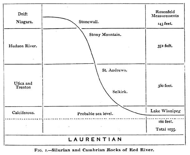
Perhaps the most useful operation we have had for obtaining an accurate knowledge of our Red River valley rocks was the boring conducted by the Canadian Pacific railway in 1885 at Rosenfeld Station, 60 miles southwest of Winnipeg. By the use of a percussion drill, after boring a little more than a thousand feet, the Laurentian foundation was reached. The logbook kept by the drilling party has enabled the geologists to make out a complete section of the limestone and sandstone rocks, such as we have from no other source. It is true that these rocks at this point are thicker than had been supposed, and there are grounds for thinking that as we come northward to Winnipeg they will not be so thick. The revelations made by the drill quite fit in with the geological observations made of the Stony Mountain, Red River, and Lake Winnipeg exposures. It is now possible to make out a general view of the rock formations from the boundary line to the basin of Lake Winnipeg. Figure 2 is an attempt at this, showing the rocks of the various ages, and their localities as observed in this valley and basin. It is based chiefly on Dr. G. M. Dawson's article (Transactions Royal society, 1886).
From the facts indicated in the above diagram, it may be inferred, that at one time the higher rocks extended over the whole valley and basin, and that some mighty agency hollowed out this vast Silurian and Cambrian trough. Undoubtedly this powerful agent was the great glacier or ice sheet of Lake Agassiz. The whole valley shows signs of this denuding and crushing power in the striae which are observed The fine drift deposit or soil which covers the rocks on our Red River prairies, if examined with the microscope will be seen to be largely of limestone rocks ground down to powder, as well as crushed rocks from the Laurentian area. The erratics or boulders found in this drift are simply larger fragments of these same rocks. Much of the material which was dug up and hurried along, no doubt, went down the glacial lake, and was carried away by the Mississippi, into which the Red River then flowed. What the surface of the Laurentian, on which the later rocks rest, may be, is unknown to us. Probably it is not flat like our prairies, but is diversified by what were once great granite ridges which had lakes lying between them.
We ought all to be familiar with the character of the rocks from the several exposures mentioned, for the limestones are largely used as building stones in our better buildings. The stone is rather pretty with its mottled varieties of yellow and white, and is at places very hard, being rather Dolomitic in composition. No doubt its greatest defect is the presence in it of fossils which prevent it chiseling well. The fossils are largely of coralline formation and suggest to us that in Silurian days these rocks were a vast coral reef, and that a tropical climate then prevailed in our northern latitudes. Our limestone in former days was used for headstones, as may be seen in St. John and Kildonan cemeteries, but it is ill suited for that purpose, being neither sufficiently hard nor homogeneous. The same thing applies to our volunteer monument erected by the people of the city, and to the Seven Oaks memorial placed in position last summer by the Historical Society. It will no doubt be thought unpatriotic to say that for such purposes our Red River stone is not suitable.
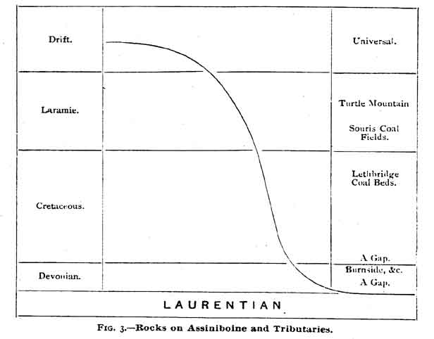
When it is remembered that the word Assiniboine means in Cree the "Stone river of the Sioux," it might be supposed it would be a favorite hunting ground for geologists. And yet this is not the case. While here and there there are gravel beds and boulders at the rapids, the rocks are generally heavily covered with drift. At Burnside, some seventy miles west of Winnipeg, on the Canadian Pacific Railway, on the banks of what is still known as Rat Creek, a diamond-drill was set agoing in 1874, (see Geological Survey reports, 1874-5) and the boring revealed rocks of a higher horizon than any we have yet seen. These have been made out to be Devoniau, but there is at this point a very thin layer, and this, strange to say, has no Silurian below it, but lies immediately on the Laurentian. To the northwest of this point, on the lakes, Devonian rocks have been described by Mr. Tyrrell and other geologists. To the west of this we reach the foot of the escarpment marked by the S.E. to N.W. trend of the Pembina, Riding and Duck Mountains. This escarpment marks the eastern edge of the second great prairie steppe, which lies one, two or more hundreds of feet above our Red River prairie level. This upper level has underlying rocks of a still higher horizon, and rocks with which as Canadians we had no acquaintance till we came to the Northwest. Figure 3 may show the sequence of rocks and their localities.
In Fig. 3 it will be noticed, that at two different stages a gap is marked This is the case in the lower instance at Burnside. Here the borers found, after penetrating 103 feet of drift beds of Devonian rock 42 feet thick, lying directly on the hard Laurentian (or Huronian). It does not of course follow that everywhere in this region the Silurian rock should be missing as in the case before us. The Laurentian rock struck in boring at Burnside is nearly as high above the sea as the top of the drift at Winnipeg, so that there was evidently a great ridge of Laurentian rock, at this point standing up as an island or cliff in the old Silurian ocean. Another gap will be noticed between the Devonian and Cretaceous. Here should have been the Carboniferous rocks, containing the coal measures, and the deposits of the New red sandstone period. No doubt the explanation of their absence is, that during those ages when the Nova Scotia and Pennsylvania great coil beds were being formed in the swamps, this region was an island standing above the ocean. It will be seen also that in the Upper Cretaceous rocks occur the deposits of coal, from which are sold in Winnipeg large quantities of Galt Mine coal, while in the Laramie just above these are found the coal beds of the Souris River, which promise to give us cheaper coal of fair quality.
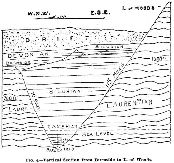
These underground revelations which we have been enabled to make on the first prairie level, may be embodied in a diagram (Fig. 4) showing the relation of the Lake of the Woods, the trough of the Red River, and the Burnside rocks. This figure indicates, taking a section of the country running in direction E.S.E. from Burnside, through the Rosenfeld rocks, and then to the south end of the Lake of the Woods, an enormous Laurentian trough. It shows also that while the Laurentian at Lake of the Woods is 1,060 feet above the level of the sea, this fundamental bed descends in the course of 115 miles to a depth of 265 feet below the sea level at Rosenfeld, or in all 1,325 feet, and rises again at Burnside, 70 miles away, to 700 feet above the sea. The probabilities, as has been said, are, that at Winnipeg the trough is not so deep. It seems highly probable that between the city and Lake Winnipeg there runs from east to west below the Silurian and Cambrian a ridge of Laurentian (or Huronian) rock connecting Burnside and the old Laurentian island, lying to the northeast of us. It may be explained that in the northern half of the Lake of the Woods there occur the metalliferous rocks now called Huronian. We have preferred to use the well known term Laurentian rather than Archaean, which some are now employing to include both Laurentian and Huronian.
It may be well now to discuss the economic products of the region under consideration. It is evident that if we are to seek for gold and silver this must be done by going eastward toward Lake of the Woods, or on the east of Lake Winnipeg. Many claims have been taken up on the Lake of the Woods, companies formed, and reducing works at Rat Portage begun. From assays made by Mr. Hoffman, the Government analyst at Ottawa, and by others, it is quite certain that there are gold and silver in that region. A number of assays have been made of rock from that district for nickel, but so far as known to the writer without result. As to iron, the deposits on Lake Winnipeg in the rocks lie near the base of the Cambrian, and are very large. Many specimens of Hematite, seemingly of excellent quality, have been exhibited. A good deal of trouble has arisen in the development of our mines from the dispute between the Dominion and Ontario Governments as to the title of the land. Our great lack, however, is that of capital to develop these mineral resources. Probably the requisite means must come from Britain or the United States, for it is unwise to divert the limited means at the disposal of our people from legitimate business to this precarious industry.
In the possession of the Historical Society are three collections of the building stone of the Red River valley. These almost all belong to the limestone rocks we have been describing, which are of Trenton and Hudson River age. While this stone is perhaps our only present resource, it is plainly rather unsuitable for finer kinds of work. Sandstone also is found at Grindstone Point on Lake Winnipeg, but it is rather brittle. Some marbles occur on Lake Manitoba, and it is altogether likely that as our northern lakes and water courses are explored building stone of superior quality will be obtained.
Judging by the occurrence of salt in Western Ontario and looking at our Silurian rocks we should not expect it to occur until we pass some distance west of Stonewall, where as we have seen what appears to be the Niagara limestone is found. Salt in Ontario and New York state is found in the Onondaga or Salina formation lying above the Niagara. Seventy years ago as we learn, there were salt springs known near Pembina. The nearest salt springs to Winnipeg city are in the valley of Riviere Sale, a few miles this side of the railway station of Oakville on the Northern Pacific Portage branch. Other springs are found on Lake Manitoba, while near the Marais river, some 55 miles south of the city well known springs occur, and in the Rosenfeld boring a great flow of brine was struck. From these indications we can infer that, though the rocks are not visible on account of the drift, salt bearing strata run across the country from Lake Manitoba, east of Poplar Point, east of Oakville, and near the town of Morris. Of course the lower rocks, may have brine filtered through them from above, where the upper rocks are salt bearing. This was actually the case at Rosenfeld, where the strongest flow of brine was met below the Trenton. The force of the brine at Rosenfeld was so great that it rose in a pipe eighteen feet above the surface of the prairie. This Rosenfeld salt was examined by Mr. Hoffman, of Ottawa, and was declared to contain paying quantities of excellent salt. Indeed the old Fort Garry salt, which was sold twenty years ago, though black with impurities, was of good quality. In old Red River days, a manufactory of salt was carried on from 25 salt wells on Lake Winnipegosis by James Monkman for the Hudson Bay company. The old price was 12 shillings sterling a bushel. No doubt salt making will become one of our industries, but to compete with eastern salt it will probably have to be worked with sawmills on Lake Manitoba and Lake Winnipegoosis, as is done in the Saginaw district of Michigan, where the refuse from the mills is utilized for providing a fuel without cost.
The great value of petroleum to the country, and the fact that on the Mackenzie river there are petroleum springs, and large areas of maltha or mineral tar, has led to the speculation, even among geologists, that coal oil might be found in our province. In the east, petroleum is found in the Middle Devonian, or Erian, as it is now beginning to be called. Accordingly it is impossible that petroleum should be found east of Lake Manitoba. As, however, Devonian rocks occur, as we have seen, at Burnside and at a number of places on Lakes Manitoba and Winnipegosis, it would seem worthwhile to search for petroleum in that western region. Companies have been formed, one especially, of which the writer remembers, to bore for oil in the Lake Dauphin district. Theoretically it is right enough to examine this region thoroughly, but surface indications and the opinion of practical miners should be taken as well.
The first determined effort to seek coal in Manitoba was made nearly twenty years ago, when a party of the Geological survey spent a summer in the Swan Lake district on the slope of Riding Mountains. Here geology held out hope in the gap between the Devonian and the Cretaceous where the Carboniferous rocks of Eastern Canada and the United States are found. The search proved vain. But in 1872 Dr. G. M. Dawson, the geologist accompanying the boundary expedition, came upon coal beds upon the Souris river. The writer remembers well a company of Winnipeg gentlemen shortly after taking coal claims at the Souris. The coal was unfortunately classed as poor Lignite, and was rather despised. As the west was opened up it began to dawn upon explorers that Northwest coal had some value in it. It was found that the "Galt mine" at Lethbridge was of Cretaceous age, and indeed of the same horizon as the famous Nanaimo coal on Vancouver Island. The beds of the Pembina Mountains escarpment seem of the same age, but are of deep sea origin. It was noticed that the Laramie beds lying in the neighborhood of Blackfoot Crossing contained good coal, and the Souris beds proved to be of the same age. The beds on Turtle Mountain, which is another deposit of Laramie age, also contain a fair coal. Some years ago Mr. Hugh Sutherland brought a scow load of coal down the Souris from the coal region, and in another season the railway will carry this coal all over Manitoba. The exposure on the Souris river is one of remarkable thickness, and is very accessible. No doubt as the seam is penetrated the coal will improve in quality.
A visit of the writer last year to Indiana gave him an excellent opportunity of seeing the importance and uses of natural gas as a fuel and light-producer. Great use is being made of it to some parts of China, and it has been found in large quantities in Ontario near the Niagara river. It is said to arise from the Trenton beds, and is accounted for by the vast number of fossils found in that formation. Its origin is as mysterious as that of petroleum. At Langevin Station on the C.P.R., 33 miles west of Medicine Hat, the writer saw a stream of natural gas, rising from a boring, which had been used for several years in the section house for fuel. In this case the gas has its origin in the Cretaceous. So far as finding natural gas below Winnipeg is concerned, our underlying rook is Trenton, and it is a perfect mass of animal remains, but there have as yet been no surface indications of there being natural gas in the Red River valley, unless it be the stream struck at Dominion City last summer, and this has not yet been scientifically investigated.
A very important question for us is that of water supply. Not only comfort and convenience, but health also, demand that we face this question. Our city water works supply is from the Assiniboine, which contains a large proportion of chemical salts, and is somewhat trying for newcomers who use it freely. Wells in a city after a few years become unfit for use. Many well authenticated instances are found of typhoid fever and other diseases coming from the use of water tainted by drainage. A number of our wells, especially those west of Colony creek, are artesian. They are all in the drift and probably gain their water supply from the area exposed by Little Stony Mountain. These can hardly be relied on for supplying us with plenty of water. Figure 4 is a suggestive one in this connection. Winnipeg is 764 feet above the level of the sea; Lake of the Woods is 1,060 feet. There is consequently a difference in our favor of some 300 feet, and should there be beds of a porous nature in the Laurentian, there would be a sufficient amount of pressure to give us a good head of water. There is no way of assuring ourselves of the presence of water or of natural gas except by boring. It is by no means certain that we should get either, but, judging from the experience, especially of some points in Dakota, it would be worthwhile trying. As to the other objects spoken of, viz., salt, petroleum, coal, and precious or useful metals, the probabilities are entirely against use. The absence of salt, however, is more favorable to our getting an artesian well of good water.
When the applause which greeted Dr. Bryce on resuming his seat had subsided, President MacBeth invited an informal discussion which followed in the responses of the lecturer to enquiries and suggestions by Prof. Hart, of Manitoba College, Prof. Laird, of Wesley College, and Consul Taylor.
It was first explained that all the formations of the Red River valley, resting on the Laurentian development, corresponded with the upper and lower Silurian of the English geologists. Then, looking westward, Consul Taylor expressed his great unwillingness to believe, that the carboniferous Devonian formation - the seat of bituminous coal in the United States would be found wanting, or "a fault," between the Red River valley and the cretaceous formation clearly recognizable beyond Brandon. He would rather expect that by further exploration, the true coal measures as developed at Pittsburgh and by deep-sinking in Iowa and Missouri, would yet be traced from the Pembina to the Riding Mountains of Manitoba. A further point of interest, which Dr. Bryce fully admitted, was that the great Laurentian Island was succeeded northward, as he had illustrated southward through the Red River valley, by the development in even fuller extent of the Silurian and successive geological strata, with the highest probability - unless all geological analogy elsewhere shall fail of application to the districts in the vicinity of Hudson's Bay - of the existence of bituminous coal fields and valuable minerals in the far Northeast of Canada.
Prof. Laird, in expressing his high appreciation of the learning and exposition of the lecturer, dwelt briefly upon the great accessions to the materials of geological science by the elaborate surveys of the world; and joined heartily in the recognition of Dr. Bryce's zeal and intelligence in giving a popular form to a discussion of great public interest.
On motion of Consul Taylor, seconded by Prof. Hart, a vote of thanks was heartily tendered by the audience, and appropriately acknowledged by the lecturer.
Sir, - In your issue of Christmas morning appeared a letter from Mr. Tyrrell of the Geological Survey criticizing my lecture on the "Oldest Geology of the Red River and Assiniboine Valleys." I have not until the present time had an opportunity of noticing it. With your permission I shall quote the various criticisms one by one, that none may be omitted.
1. Mr. Tyrrell says: "The original Archaean continental nucleus, spoken of as the 'Laurentian Island,' extends southward into Minnesota, Wisconsin, Michigan and New York, and therefore Canada should not be said to own the whole of this Laurentian Island, but rather the greater part of it. The use of the term Laurentian, instead of Archaein to include both the Laurentian and Huronian, is not correct, any more than it would be correct to group both men and horses as horses. Laurentian and Huronian were names applied by Sir William Logan to separate geological groups or systems, and as they have not been shown to be the same the one named cannot be used to include them both without causing bite utmost confusion."
The use of Laurentian instead of Archaean was simply to prevent confusion in a popular discussion of the subject. I said distinctly as follows: "We have preferred to use the well known term Laurentian rather than Archaean which some are now employing to include both Laurentian and Huronian." The terms "Laurentian island" and "Laurentian lakes" have now become well known, including as everyone knows the Huronian. The distinction between Laurentian and Huronian is not easily drawn. Prof. Chapman (page 298) says: "The stratigraphical relations of two series, Laurentian and Huronian have not yet been clearly made out. The mineral characteristics and especially the presence of conglomerates holding gneissoid and other fragments lead undoubtedly to the conclusion that the Huronian beds are of later formation than the Laurentian, but as pointed out by Dr. Selwyn, the Huronian appear in many places to pass under the latter." It is well known that members of the geological staff form the opinion that the Laurentian series are not metamorphic sedimentary rocks, and their relation to the Huronian is very uncertain. How absurd it is then to be dogmatic, the more that it has been found necessary to invent the colorless word "Archaea" to include the Laurentian and Huronian. As to the event of the "Laurentian island" the portion of the Laurentian uncovered by Palaeozoic which is outside of Canada is utterly trifling compared with the vast area within our borders.
2. Mr. Tyrrell says: "The iron ore on Lake Winnipeg does not occur in "Cambrian" rocks, but, as has been pointed out by the writer several times, in the highly altered schists of the Huronian system. There is no known natural outcrop of "Cambrian" rocks in Manitoba, and the only record of this system in the province is in Dr. Dawson's paper on the boring at Rosenfeld where he correlates the lowest 110 feet of his section with the Lower Magnesium Limestone or Calciferous, adding a (?) to indicate a certain amount of doubt in the correctness of the determination."
Here Cambrian is used to mean the lowest of what were formerly called Silurian, and must now be admitted to be at least Campro-Silurian. Dr. Dawson is correct in identifying the rocks immediately above the Laurentian at Rosenfeld as Calciferous, which is Cambrian. As in the case of the Quebec rocks of Eastern Canada, it is difficult to separate chalky and Calciferous, and especially in Manitoba is it difficult to get a horizon corresponding exactly with that of Ontario. As to the iron bearing rates my statement was that they "lie near the base of the Cambrian," lie on the Laurentian island of which I had been speaking, very near the point of union of the Palaeozoic and underlying rocks.
3. Mr. Tyrrell says: "Possibly the most unfortunate sentence in the whole paper is the following: "Lake Winnipeg is now definitely known to be a broad trough hollowed out by glacial action, on the east shore consisting of the hard granite and conglomerate of the Laurentian, and on the west of its lower rocks of the Calciferous, and probably Potsdam series, now classed as Canadian rocks lying upon the Laurentian.
Lake Winnipeg is not definitely known to have been hollowed out by glacial action. It is much more probable that it is an old pre-glacial river valley, of the general character of that of the Mississippi of the present day, with its northern end blocked by drift and alluvial deposits, or a depression has been formed in the bottom of this old valley by movements of the earth's crust; evidence of these crusted warpings being seen in the high beaches along the foot of the Manitoba escarpment. On the east shore of Lake Winnipeg there is no "conglomerate" known in the Laurentian, and in fact it is more or less doubtful whether there is conglomerate anywhere in the Laurentian. On the west shore no "Calciferous" or "Potsdam" is known, and there is no reason to suppose that there are any palaeozoic rocks in that vicinity below the St. Peter's sandstone (chazy) which is there found resting directly on the archaean."
The last first. After the explanation to regard to Laurentian it seems mere trifling to deny the presence of conglomerates. Prof. Chapman (page 297) says: "The Huronian representatives although distinct enough in their entirety, closely resemble in many cases the Laurentian rocks of the district, and cannot always be readily separate from them. As a rule, however, the texture is less crystalline or less granitoidal, and slaty or semi-crystalline conglomerates appear among them." Mr. Tyrrell seems to especially object to Lake Winnipeg being so decidedly put down as hollowed out by glacial action. In my lecture of last year I had occasion to point out the distinguished service in geologizing Manitoba, performed by Prof. Upham, of Boston. So completely did Prof. Upham's theory satisfy the conditions that impartial observers immediately set it down as a proved hypothesis. The fact of its being so is shown in the unusual course of the Canadian Government geological survey in publishing Mr. Upham's report of 156 pages, though the author belonged to a foreign service. This course seems to have displeased some members of our geological staff. To any one who examines the two pages (113 and 114) of observations as to glacial striae, and finds such an entry as "Between the Hudson bay and Lake Winnipeg, along the Severn, Fawn, Poplar and Beren's rivers, on almost all exposed rock surfaces (A. P. Low) the glacial striae run S. W." ; and also (page 115) "On the east shore of Lake Winnipeg between the Narrows and the mouth of Winnipeg river at numerous localities the glacial striae are S W.," it must be evident than in its course the tremendous ice sheet could not have done other than scoop out Lake Winnipeg. We may, however, admit the possibility of there having been in the pre-glacial age a river valley to begin with.
4. Mr. Tyrrell says: "Finally, it would be interesting to know if the lecturer has any evidence of the "Trenton" age of the rocks beneath the city of Winnipeg, as a specimen received from a well bored at the water works at Armstrong's point consists of soft and argillite, the same as that at Stony mountain, and clearly indicates, in default of evidence to the contrary, the Hudson river age of the rock immediately underlying the drift and alluvium on which Winnipeg is built."
The discussion at this point was as to the occurrences of the "Trenton" rock from which natural gas is supposed to come. Dr. Dawson shows that there is "Trenton" at Rosenfeld south of Winnipeg; it is shown by Prof. Panton and others that the Trenton is found at St. Andrews (north of Winnipeg). Mr. Tyrrell says probably Hudson river bed immediately underlying the drift at Winnipeg; and since Trenton underlies Hudson river it is almost a certainty that the Trenton lies below Winnipeg and can be reached by boring.
5. Mr. Tyrrell says: "It is also stated that 'some marbles occur on Lake Manitoba,' whereas it is quite certain that no such rock is found anywhere around that lake, and, in fact, there is no crystalline limestone or 'marble' known anywhere in Manitoba up to the present time."
Prof. Hind states that he found on St. Martin's lake, which is connected with Lake Manitoba by the short Partridge Crop river, and which is also connected with Lake Winnipeg, "partially metamorphosed sandstone rocks," at one point the "rock approaches the character of gneiss," "an inland consists of gneiss with large quartz veins meandering through it," while further on were found "fragments of silicious limestone." It is locally believed that there is crystalline limestone in that region, and certainly the conditions described by Prof. Hind favor this view. These are all the matters raised in Mr. Tyrrell's criticism, and it will be seen that they are almost all debatable points.
George Bryce.
Manitoba college,
Winnipeg, Dec. 31.
Page revised: 22 May 2010