by Gordon Goldsborough
Winnipeg, Manitoba
|
The MHS is compiling an inventory of historic sites around Manitoba as an encouragement to tourism and management. Some sites in that inventory are featured in issues of Manitoba History. Eds.
 |
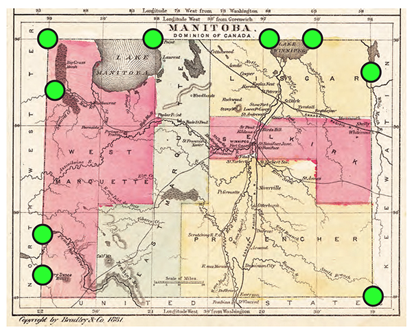
The locations of nine monuments commemorating the “postage stamp” boundaries of Manitoba are superimposed on this 1881 map of that smaller province. |
Manitoba is sometimes called the “Keystone Province,” not because its shape vaguely resembles a key but because, when it was first established in 1870, its shape was reminiscent of the essential stone in a Roman stone arch. A keystone with its slightly bevelled edges, sitting in the arch’s centre, held up the entire structure. In an analogous way, the Manitoba keystone linked western and eastern Canada as one nation.
Early Manitoba was also called the “postage stamp province” for its proportions were approximately like those of a stamp. It measured just 130 miles (210 kilometres) wide and 110 miles (177 kilometres) tall. Travellers heading west from Winnipeg entered the North West Territories just past Gladstone on the west and Winnipeg Beach on the north.
In 1881, Manitoba’s eastern boundary extended to its present junction with Ontario, and it went west to meet what is now Saskatchewan, and northward to near the top of Lake Winnipegosis. Then, in 1912, the northern boundary extended to its present meeting with Nunavut. Only in 1955 was the angled border between Manitoba and Ontario to Hudson Bay finally resolved.
Nine monuments around the province mark the edges of the original “postage stamp.” Six were erected by the provincial government; the others were installed by local groups. They remind us that Manitoba was once a small experiment on the Canadian landscape that has blossomed and grown.
We thank Clara Bachmann for assistance in preparing the online version of this article.
We thank S. Goldsborough for assistance in preparing the online version of this article.
Page revised: 14 April 2020