by Norma Hall
Winnipeg, Manitoba
|
The maritime component of the Hudson’s Bay Company (HBC), though fundamental to its trade, is an aspect of its influence in the North-West that is often overlooked, despite readily apparent clues. The Company’s yearly outfit, for example, was set when ships were outfitted to voyage to Hudson Bay at the beginning of June. The posts built on the shores of Hudson and James bays were first of all ports—built by ships’ crews and located where ships could go. “Ship time” marked the beginning of the trade season in the North-West. The master-servant relationship on shore was a reflection of a long-standing relation aboard ship, and, historically, masters ashore (at least those stationed bayside) were often mariners—people like Richard Norton, his son Moses Norton, and Joseph Isbister—as were Company founders and committee members such as Prince Rupert, Pierre-Esprit Radisson and Captain George Spurrell. Inland surveyors of renown were trained in mariner methods as well—from Henry Kelsey and Samuel Hearne to David Thompson. [1]
The nature of HBC seafaring can be gleaned from ships’ logs that indicate where ships were and what work was being done, from journals that impart glimpses of the social life aboard ship, and by comparing data—about ships, routes and sailors—with what is known about seafaring that took place elsewhere. [2] Surveying transatlantic shipping to Hudson Bay, from the late 1600s to the early 1900s, reveals that each voyage was unique in terms of conditions, a ship’s complement, and encounters. Nevertheless, Company records show enough regularity to support a general description, broadly representative of HBC ocean crossings of the northernmost extent of the North Atlantic. Such a description follows: defining the Northern North Atlantic as a distinct portion of the maritime world, then furnishing an unrealistically brief view of an ocean crossing, followed by a description of the ships that were workplaces and social spaces, and finishing with a mention of seafarers associated with Red River Settlement.
The point made is that the Western Canadian present is not an arbitrary circumstance, but a context arising out of a historical process with an ocean-crossing dimension. When contemplating the dynamics of this process, notably at Red River, but in other locations as well, there is merit in thinking beyond shorelines to take seafaring experience into account.
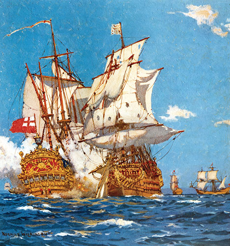
Battle in the Bay, 1697. This painting by Norman Wilkinson was featured on a 1937 HBC calendar. It portrays a battle for fur trade supremacy between the French ship Pelican under the command of Pierre Le Moyne d’Iberville and three British ships.
Source: Archives of Manitoba, Hudson’s Bay Company Archives, HBC Calendar Series, P-401, 1937.
Ocean crossings to Hudson Bay shared aspects of merchant voyages on shipping lanes, just to the south, that connected European ports and those of the Eastern Seaboard of North America. Nevertheless, HBC seafaring was distinct. First, sailors and seafarers dealt with a different set of natural features. Second, their ships, as workplaces, were more crowded and in some respects more complicated to handle. Third, they underwent a singular social experience, due to the first two factors and because the people who made up a ship’s community were overwhelmingly “Company” people—including individuals who were native to North America.
The space traversed by HBC ships was markedly northern. Canadian historians generally situate the North between 54° and 66°33′35″ North latitude, above the fertile belt of the prairies, and below the “eternal ice and snow” of the Arctic. [3] Company voyages also dipped into Canada’s Middle North in James Bay. And, at their eastern end, voyages crossed what maritime historians have designated the North Atlantic. Geographically speaking, the oceanic space of historical HBC sea voyages was not properly a region, because that term applies to land. Rather, the space of Company voyages was an ocean arc—a term for a continuous watery plain over which sailors repeatedly sailed their ships. The sailors on transatlantic HBC ships to the Bay, in working across a HBC ocean arc, made it a known place—naming it, mapping it, and recording its features in logs, journals, and pilot books.
Natural features made the HBC ocean arc distinctive. The East- and West-Greenland currents were convenient, carrying ships across the Atlantic at the rate of ten to fourteen kilometres a day around the southern tip of Greenland and thence to the entrance of Hudson Strait. Sailors also took advantage of the wind. On the Northern North Atlantic, it blew more consistently as a fair wind (sending a ship in the right direction), than did the highly variable winds just to the south. Wind was nowhere near as reliable as currents, however. Charts that show prevailing winds illustrate high-altitude patterns, not the surface winds generated by local weather systems. Because sea winds could blow from any point on the compass, voyages did not necessarily follow the unwavering lines commonly laid down on maps showing shipping routes. Though sometimes a captain was lucky, the wind was regarded as a “fickle lady,” and voyages were much more zig-zaggy affairs, often with stalls, and even reversals. [4] One spot where stalls occurred was known as the Stormy Forties. The name, however, did not refer to weather, rather it signalled water conditions. Three major currents (the West Greenland, Labrador, and North Atlantic Drift), met in “aqueous mountains”, just below Cape Farewell, Greenland, situated longitudinally between about 40° and 50° West. [5]
The location of the Forties was somewhat provisional. Although the Greenwich meridian was established as 0° longitude in 1750, up until about 1888 HBC captains customarily set 0° longitude at Hoy Head, in the Orkneys. On reaching Hatten’s Head on Resolution Island, Hudson Strait (somewhere around 65° W), they would “resolve” longitude, by resetting it to 0°. Regardless of whether the Hoy Head or Greenwich meridian system was adopted, the Stormy Forties, as a point of transition, could be felt. If ships to Hudson Bay stalled there due to foul (meaning unfavourable) winds, or to no wind, all on board were subject to a “boisterous” experience — endured by Selkirk Settlers for fifteen days in 1811. [6]
Even on a rapid transit, in crossing the Forties seafarers bid “farewell” to the kind of sailing encountered elsewhere in the North Atlantic, because they met with ice. Carried down from Arctic seas by currents, through spring break-up to late summer, ice—as bergs, fields and shattered remnants of both—was a primary determinant when it came to the distinctiveness of Northern voyaging. Icebergs were eagerly looked for by passengers, as visual evidence of having entered decidedly Northern space. On the other hand, by the time ice was encountered, sailors were more interested in sighting land, to know where they were relative to “home.”
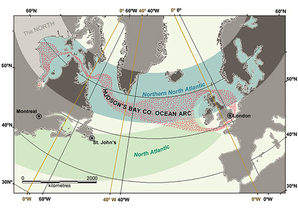
The Hudson’s Bay Company Ocean Arc.
For mariners, determining whereabouts was at all times a primary concern. They set out on HBC voyages from the London River. The Pool below London Bridge marked the inland end of the home port for deep-sea ships. The nautically minded called the river above the bridge the Thames. The lower stretch, to the river’s mouth, they called the London River, after the port. The river was congested, and marked by very bad smells emanating from sewage, rotting garbage, and drowned “river waifs.” [7]
HBC ships bound for the Bay moored at Gravesend Reach. There, the vessels were outfitted with crew and cargo, and took on passengers. From Gravesend, depending on weather conditions, it could take from two days to two weeks to get down the river to its estuary, thread the channels and pass the sand bars into open seas.
Sailing “north about,” up the east coast of England to Stromness on the Orkney mainland, took approximately two weeks, perhaps a few days more. It all depended on whether a ship put into a port along the way, how long it stayed in port, and whether wind was blowing in the right direction. Occasionally, ships instead went “west about” through the English Channel, or departed from other harbours, such as Stornoway, on the Isle of Lewis, Hebrides archipelago, and Sligo, Ireland (with Selkirk Settlers aboard, in 1811 and 1812, respectively). But, assuming a ship took the north about passage, on reaching Stromness it might anchor for one week or three, depending on tasks that remained to be done—from loading supplies, to hiring additional crew, to waiting for consort vessels to arrive. For safety, HBC ships crossed the Atlantic in convoys. During times when warfare was of concern, which was fairly often, Admiralty vessels would escort the convoy.
Ships would take leave of the Orkneys at Hoy Head, about 58°55’ N. By this point, a Company ship might have been at sea for as much as a month or more of difficult sailing, the crew contending with troublesome tides, rocks and shoals that marked all passages around the British Isles. Once on the Atlantic, however, sailors could anticipate uninterrupted sailing ahead, holding to a course along the bands between 56° and 60° N. for approximately 2,250 kilometres to Cape Farewell, Greenland. Covering an additional 1,125 kilometres would bring them to Hatten’s Head, Resolution Island.
While mariners might hope to make the entire crossing in as few as nineteen days (as Captain William Kennedy managed in 1851), or in a record-breaking seven days (set by Captain David Herd in 1861), the passage was more likely to take three or four weeks. In terms of visual points of interest, seafarers tended to record the Atlantic crossing as “long, monotonous and dreary.” [8] They also reported getting wet, especially in the Forties—in high seas ships leaked. As they rounded Cape Farewell, Greenland, and approached Hudson Strait, the cold became intense, which seafarers attributed to the presence of ice.
It was no mean feat to enter Hudson Strait, because currents carried massive amounts of ice southward across its opening. However, currents also dipped into the strait at Resolution Island. If collision with large bergs (and the island) was avoided, then drifting into the strait surrounded by the “small ice” of late July was a relatively safe entrance to effect.
Once in Hudson Strait, passage through it could take as many as six weeks or as few as four days, depending on whether the strait was closed by ice, or open. From at least the early 1700s, ships would pause midway, to trade with Inuit for whalebone. Trade was not always possible. Ice could limit manoeuvrability and prevent a ship from stopping, because the ice was always moving. It flowed westward along the north side of the strait, and eastward along the south. For this reason, fortuitously for the HBC, even ships thoroughly beset in ice would eventually exit the strait.
Once out into Hudson Bay, ships could take from three days to four weeks to cross to Churchill Harbour or Port Nelson, and longer still to get to the Bottom of the Bay. Here again, timing depended principally on the presence or absence of ice. The voyage home, in September, was usually—not always—shorter. A late arrival in the Bay, or an early onset of winter freeze-up, could force a ship to over-winter.
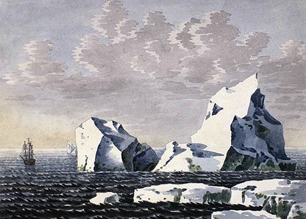
Greenland Ice. Peter Rindisbacher’s watercolour painting portrayed the encounter of ships with icebergs in the vicinity of Greenland on 26 June 1821.
Source: Library and Archives Canada, Acc. No. 1988-250-3.
HBC ships carried sail into the 20th century. Although the size of Company ships increased over time, they began and remained small in comparison to merchant vessels in other seas—ice sailing required tight turns and rowing and towing by crews. HBC ships had rounded bottoms to lift them up and out, if ice crushed inward, and they were shallow in draught to deal with the shallowness of Hudson and James bays. Consequently, they were tricky to handle in rough seas—they could roll alarmingly and sometimes travelled sideways as readily as forward.
Sail ships with auxiliary steam engines were not typical HBC transatlantic vessels. Instead, sail-steamers travelled a coastal circuit from Montreal to the Bay. Coal in their holds limited cargo capacity. By 1920, the company’s newer ocean-crossing ships were fully steam-driven and significantly larger. As workplaces, however—whether steam or sail—the ships were crowded. They had confined quarters, with equipment, livestock, and people stowed everywhere. Additionally, although the ships were small compared to merchant vessels elsewhere, they carried a greater number of officers and crew—as many as a third more.
Partly to maintain order in crowded conditions, the space aboard ship was highly structured socially. Depending on one’s job, there were places one was allowed to be and places one was not. Nonetheless, even with these restrictions, there was opportunity, and time, to mingle with people from all over the globe. Seafaring was integrative, in that sailors of different geographical and cultural origins worked together, a condition that was the norm throughout the Atlantic World. On the foredeck—the sailors’ space for working, relaxing and interacting with passengers—stories, songs, and jokes were exchanged. Seafarers, who were native to North America and working or travelling from place to place in the Bay, or across the ocean, participated in this exchange.
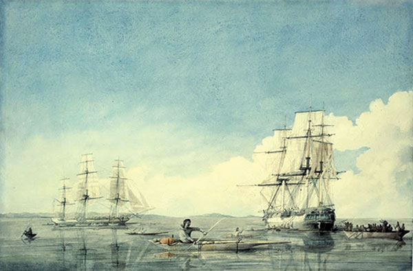
Inuit Barter. In this Robert Hood watercolour from 1819, the HBC ships Prince of Wales and Eddystone are shown bartering with Aboriginal people off the Upper Savage Islands in Hudson Strait.
Source: Library and Archives Canada, W. H. Cloverdale Coll. of Canadiana, Acc. No. 1970-188-1271.
Before the mid-18th century, men, women and children from Europe and from North America—working and non-working—mingled aboard HBC ships for months at a time. HBC sailors and seafarers were mobile people, circulating widely in North America and around the world. Not a few “swallowed the anchor” to settle as landsmen in Red River, where they contributed to the mix of information about the wider world at that settlement.
Among accomplished former Company sailors to retire to Red River, there was Captain William Kennedy. Born in 1813 at Cumberland House, to Chief Factor Alexander Kennedy and Aggathas, he was sailing the seas off Labrador in HBC vessels by 1838. By 1848, he was master aboard his own ship on Lake Superior. From 1851 to 1856, he commanded two sailing expeditions to the Arctic in search of Sir John Franklin, during which he crossed from New York to Liverpool, Aberdeen and London; wintered in the Arctic; and sailed round the Horn to Valparaíso. As of 1861, he resided at Red River, building Kennedy House in 1866. [9]
There was also Captain Colin Robertson Sinclair, born in 1816 at Norway House to Chief Factor William Sinclair and Nahoway. By 1830, he was working on transatlantic voyages through Hudson Strait and out of Newfoundland. By 1840, he was master and owner of a ship in the China and East India trade. He retired to Winnipeg in 1897 to reside at his sister’s family home—Seven Oaks House. [10]
And then there was Ranald Macdonald. Born in 1824 at Fort George on the Pacific Slope to Chief Trader Archibald McDonald and Koale Koa, he was grandson of Chief Comcomly, who was harbour pilot for the HBC on the Columbia River. Macdonald lived at Red River while attending school from 1834 to 1838. By 1841, he had begun working his way to Japan by sea. He set the experience down, circa 1888, in a manuscript that was finally published in 1923. [11]
The Hudson’s Bay Company Archives has compiled biographies that indicate there were many more transatlantic sailors, coastal sloopers and boatmen, along with servants working passage aboard ship, who migrated from the Bay and elsewhere to live at Red River. They began making an impression there at least as early as 1815 and continued to do so until well after Winnipeg’s incorporation as a city in 1873. Passengers of HBC vessels did likewise. [12]
Along with the ocean-going Selkirk Settlers, there were men, women and children of families inextricably woven into the history of the Settlement and of Western Canada, who depended upon the HBC transatlantic link to Europe for the movement of people and supplies. Many were directly acquainted with the Northern North Atlantic in ways that 21st-century Canadians are not and perhaps never can be. Seafarers aboard HBC ships spoke, worked, and travelled their way into historical process, learning by experience that seas, as seeming barriers, could also be bridges.
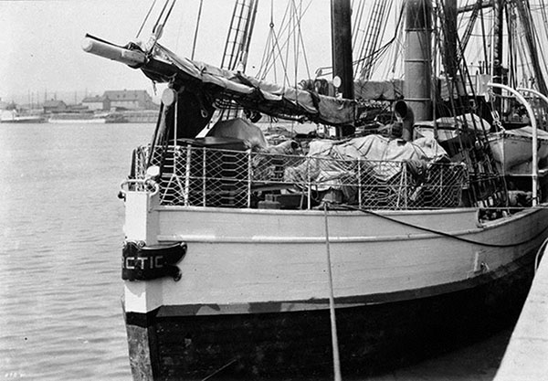
Loaded for commerce. This 1908 photo by John Woodruff shows the heavily loaded decks of the steamer Arctic as it prepares to get under way for travels between HBC posts in the Canadian North.
Source: Library and Archives Canada, W. H. Cloverdale Coll. of Canadiana, Acc. No. 1970-188-1271.
1. See Norma Hall, “Seafarers”, Dictionary of Canadian Biography and Hudson’s Bay Company Biographical Sheets, Northern Arc: the Significance of Seafaring to Western Canadian History, doing canadianhistory n.0, http://hallnjean.wordpress.com, accessed 2 January 2013.
2. See Norma Hall, Northern Arc: The Significance of Shipping and Seafarers of Hudson Bay, 1508–1920, Ph.D. dissertation, St. John’s: Memorial University of Newfoundland, 2009, available on-line from Electronic Theses and Dissertations, Digital Archives Initiative, Memorial University Libraries, http://collections.mun.ca/cdm4/document.php?CISOROOT=/theses4&CISOPTR=69051&CISOSHOW=68398, accessed 2 January 2013.
3. William Dennis, “The Sources of North-Western History,” MHS Transactions, Series 1, No. 6, read 1883, p. 2.
4. William Coats, The Geography of Hudson’s Bay, ed. John Barrow, London: Hakluyt Society, 1852, p. 10.
5. Isaac Cowie, The Company of Adventurers, Toronto: William Briggs, 1913, p. 86.
6. Library and Archives Canada, Thomas Douglas, 5th Earl of Selkirk Fonds, Microfilm A.27, Selkirk Papers, vol. I, Miles Macdonell, letter to Lord Selkirk (York Factory, 1 October 1811), p. 46.
7. Walter Thornbury, “The River Thames”, Old and New London, vol. 3, New York: Cassell, Petter and Galpin, 1878, p. 303.
8. Cowie, Company of Adventurers, p. 84.
9. See William Kennedy, A Short Narrative of the Second Voyage of the Prince Albert, in Search of Sir John Franklin, London: W. H. Dalton, 1853; Scott Polar Research Institute, University of Cambridge, GB 0015, William Kennedy collection (1851–1856), MS 248/433/1;D Letter to Sophia Cracroft (n.d.), and MS 248/433/2-8;D Letters to Jane, Lady Franklin, 6 July 1851 to 23 January 1856; Edward C. Shaw, “Captain William Kennedy, An Extraordinary Canadian,” MHS Transactions 27, Series 3 (1970–1971 season); and Edward Charles Shaw, Captain William Kennedy, Winnipeg: Manitoba Culture, Heritage and Recreation, Historical Resources Branch, 1985.
10. See Norma Hall, “Captain Colin Robertson Sinclair,” doing canadianhistory n.0, http://wp.me/Pz2Dv-iu, accessed 2 January 2012.
11. Ranald MacDonald, Ranald MacDonald: The Narrative of his early life on the Columbia under the Hudson’s Bay Company’s regime; of his experiences in the Pacific Whale Fishery; and of his great Adventure to Japan, ed. William S. Lewis and Naojiro Murakami, Spokane: Eastern Washington State Historical Society, 1923.
12. See Hudson’s Bay Company Archives [HBCA], Biographical Sheets, www.gov.mb.ca/chc/archives/hbca/biographical/index.html, accessed 2 January 2013. Early arrivals include ship’s surgeon and factor, Thomas Thomas, in 1815; sailor and sloop master, Joseph Brown, 1816; and ship’s surgeon, William Todd, 1818–1819. See also HBCA, E.5/1, 1827 Red River Settlement Census, which lists sailor ‘Jack Tar’ Saunders and boatman Soowamis.
Page revised: 6 January 2018