by Graham A. MacDonald
Parks Canada, Calgary
|
At the time of the 1885 Métis Resistance around Batoche, Saskatchewan, an event long-associated with the name of Louis Riel, a detachment went to the front from the Rockwood District of Manitoba’s Interlake country. They were part of the 95th Battalion D Company and it included men with such familiar western Canadian names as Ellis, Lusted, and Rutherford. The Captain of D Company was an Irish immigrant, Samuel Jacob Jackson, a man of considerable past and future achievement in the young province of Manitoba. When Jackson led his contingent to the valley of the Saskatchewan River he already had behind him experience as a Winnipeg merchant, alderman, and member of the Provincial Legislature. Jackson had come to Manitoba from Ontario in 1871. He undertook a number of jobs before accepting a clerk position with John Higgin’s dry goods store in Winnipeg. By 1876 Jackson was homesteading in the Grassmere area a few miles northwest of the city near present-day Stonewall, and he quickly came to take an interest in the abundant limestones which characterized that vicinity. At the time much excitement surrounded the route selection of the Canadian Pacific Railway and this encouraged Jackson to purchase lands in that area where limestone lay close to the surface. The railway would require great quantities of crushed stone for road bed establishment across the prairies. Jackson became one of the main forces behind the founding of the new town of Stonewall. Local tradition has it that surveyors working on the definition of town plots bestowed on Jackson the nickname “Stonewall” in recognition of his affinity with the American Confederate General of that name. In return, Jackson decided to give the name to the new town. His calculation that the land around Stonewall represented a favourable location for a town site from which to produce ballast for railway enterprise was sound. Even though the CPR route was relocated further south through Winnipeg rather than through Selkirk, his quarry lands were still well positioned to contribute to the construction effort. The needs of the railway provided a stimulus for town development.
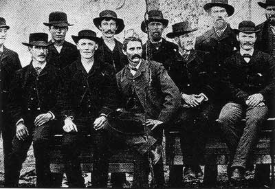
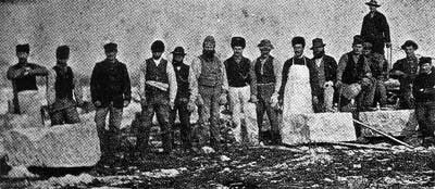
Workers at the Stonewall Quarry, circa 1900.
Source: Archives of Manitoba
In the late 1870s Jackson financed the construction of the first kilns in the town, thus initiating systematic quick-lime production, an industrial commodity for which the town would gradually achieve fame. At the same time, he made building stone available free-of-charge to any intending settlers interested in establishing homes and farms around Stonewall. By the time a colonization rail line reached Stonewall from Winnipeg in 1881, A. H. Clarke and John Gunn had already entered into cut-stone quarry work in the southern part of the town. The new line thus stimulated an even more disciplined development of building stone operations, useful for servicing the building demand in Winnipeg.
The actual location of Jackson’s original lime kilns is uncertain, but they were near the setting of today’s Stonewall Quarry Park in the north end of the town. These kilns were dismantled or altered in 1882 after two experienced limeburners from the Great Forest of Dean in Gloustershire arrived in Stonewall. Enoch Williams came to Canada in that year, joining his brother, Joseph, who was already working in Selkirk. Samuel Jackson could not have been more pleased with this development, for as a businessman, soldier, and politician, he undoubtedly viewed himself as a rank amateur in the art of lime production. The Williams brothers on the other hand, had been reared to a practice which was of great antiquity in the Welsh borderland country of the Severn and Wye Rivers. It is not clear if the Williams men were in a direct line to that elusive ‘John Williams called by the name of Skimmington’ who played such a prominent role in the revolt of the miners in the Forest of Dean between 1628 and 1631. This particular Williams was ‘the most Principal Offender and Ringleader in those Rebellions and Ryotts’, a time when aristocratic movements were afoot to ‘enclose’ large portions of the forest from its customary users. [1] Regardless of pedigree, the two immigrant brothers prosecuted their ancient trade to good and long effect. In the early 1980s, the Town of Stonewall opened its new Quarry Park, and among other industrial remains, vestiges of the Williams ‘pot kilns’ are preserved here.
In 1982 the Town of Stonewall in Manitoba’s Interlake country sought to expand its industrial and tourism capacity through an approved development plan and with the guidance of a tourism feasibility study. One of the important proposals was that the town consider expansion of the existing Kinsman Lake facility in the north end of the town. This small recreation park had grown out a project which saw the rehabilitation of a derelict quarry in the years between 1956 and 1963. The Winnipeg Supply and Fuel Company, a dominant force in the local lime production industry for many years, had donated an abandoned quarry, one which many years before had been a pond. The creation of Kinsman Lake then, with its sand beaches, was in a partial sense a return to the past. The idea in the early 1980s was to build on this earlier achievement by doing something further with the adjoining quarry properties and landmark kilns, shut down since 1968. A preliminary conceptual plan for a new quarry park was developed by students at the University of Manitoba School of Landscape Architecture and, in modified form, it was incorporated by the town into its development proposals. After further feasibility studies and planning, the park with its new trails, landscape modifications and Visitor Centre opened its doors to the public in 1985.
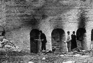
Early kilns at the Stonewall Quarry.
Source: Archives of Manitoba
Manitoba’s landscape is represented by several of the major time periods in the geological time scale. The formations are arranged in a general north-west to south-east orientation. The oldest rocks are in the Precambrian Shield which enters the province from the east around the Lake of the Woods and runs a course north-west towards Lake Winnipeg, eventually entering Saskatchewan around Flin Flon. Much of the land south of the Shield is composed of younger rocks of a sedimentary nature. These layered formations were built up from centuries of decaying vegetative and animal life, compressed into layers at the bottom of ancient inland seas. In Manitoba these rocks were formed in the Ordovician, Silurian, Devonian, Jurassic and Cretaceous periods of geological time.
The systematic mapping of these formations can be traced back to the mid-nineteenth century fur trade and the field work of Alexander K. Isbister. Having abandoned the fur trade in 1842 for the academic life of Aberdeen and Edinburgh, Isbister came under the influence of Rober Jameson who in turn had been trained by one of the leading geologists of the day, A. G. Werner. As Isbister’s biographer Barry Cooper has pointed out, these were lively and controversial times in the field of geological study. Regardless of where one stood on the interminable debates being waged between ‘neputunists’ and ‘plutonists’, the knowledge of Rupert’s Land which young Isbister had amassed made publication of his geological map a significant event. Isbister was modest and took the view that knowledge of the geology of Rupert’s Land was so basic that ‘even the most cursory classification of its formations’ would represent a useful contribution. On the Geology of the Hudson’s Bay Territories and of Portions of the Arctic and North-Western Regions of America appeared under Isbister’s name in the prestigious Quarterly Journal of the Geological Society of London in 1855. As early as 1846 however, he had published a short piece on Sir Roderick Murchison, and was well acquainted with that great geologist’s understanding of ‘Silurian’ formations and the theory of sedimentary action. Isbister’s map of the western interior was rapidly amplified in the 1860s as a result of the surveys of Dawson and Hind and of the Palliser Expedition, but as an early effort the map remained current and was frequently cited during the second half of the century. [2]
Alexander Kennedy Isbister
|
Stonewall’s post-1880 prosperity was derived from a practical encounter with the ancient legacy of the Silurian and Ordovician periods of the geological time-scale. Murchison had so labelled these limestone formations in recognition of their appearance in the home territories of the ‘Ordovics’ and ‘Silures’, those war-like Celtish tribes of ancient Wales who stoutly resisted the Roman invaders. The outcrops of greatest interest in the Interlake area are those associated with the so-called ‘Stonewall Formation’ a term first employed by E. M. Kindle in 1914. Long bands of Ordovician and Silurian limestone run in a north to south orientation and can be followed far to the north. Along the western shore of Lake Winnipeg the Ordovician sometimes surfaces at interesting outlook spots such as Grindstone Point in Hecla Island Provincial Park. Interlake limestone commerce then, owes everything to a period when much of the interior of North America was covered by warm shallow seas teaming with shell life. The constant accumulation of the shells on the Ordovician and Silurian ocean floors provided the basis of the layered limestones found throughout the great interior plains regions. The town of Stonewall is located on the boundary of Silurian and Ordovician deposits. The diorama in the Visitor Centre completed by Betsy Thorsteinson of the Manitoba Museum of Man and Nature, captures the varied undersea life which contributed to the formation of the local limestones.
Around Stonewall, these bands of rock define a gentle dome and therein lies the secret of the vicinity’s good fortune. More recent geological events played a part in revealing the limestone. With the retreat of the last glacial ice sheet from the central plains, meltwater channels often carried away softer materials leaving exposed more resistant escarpments such as the prominent one defining the eastern edge of Riding Mountain National Park in western Manitoba. These escarpment features are more subtle at Stonewall, Stony Mountain, and Garson, but the washing away of top soils left limestones exposed and waiting for later enterprising individuals to use them as they would.
Of the many quarries in the Interlake country, some produced a good quality building stone, while others were better suited for lime production. The ‘best-use’ is related to the chemical composition, the surface qualities, and band depth. In chemical terms geologists usually distinguish three main types:’ calcium limestones’ the ‘dolomites’ and the ‘magnesium limestones.’ Calcite is an essential constituent of all limestones except the dolomites. The French geologist Dolomieu distinguished ‘dolomite’ in 1791 as a rock combining calcium carbonate and magnesium carbonate, such as warranted its identity as a specific mineral. The authority M. F. Goudge described ‘the creamy white dolomite’ in the park quarries as a band about 28 inches deep, an occurrence considered to be of very high quality for quicklime production. The exploitation of this band of rock became an important part of the economy of Stonewall until 1968.
Lime production was an old and established tradition in pioneer society throughout much of North America. Settlers were accustomed to producing “batches” of lime for domestic and building purposes from simple farm-based kilns. At early seventeeth century Jamestown on tide-water Virginia, a variation of the quarry process developed based on the abundant compressed layers of coastal sea shells of that quarter. ‘For at broken Banks they discover themselves to be continued many Yards perpendicular.’ [3] In 1610 we are told that among the tradesmen who arrived at Jamestown under the command of Thomas Gates, were two ‘lymeburners.’ In rural areas ever since, variations of lime producing technology were perfected, oriented towards local conditions. Such kilns were variants of those developed in England, France and other old world centres. [4] At its simplest, little more was required to provide a modest supply of quicklime than to pile pieces of limestone on top of a good base of logs and cover the rock with clay in order to build up the heat. Survivals of the kind of farm-based technology employed by Métis and European settlers in Manitoba can still be found today by the inquisitive rural traveller.
At a somewhat denser level of social organization, the ‘pot kiln’ or ‘periodic kiln’ developed in response to community needs. Examples of this type, such as the old Williams Kiln in the park, were widespread in the years before 1900. They were usually built into a hill so that they could be fed limestone from above by horse cart. The Stonewall Pot Kiln was considerably larger than its current ruins would suggest. Stokers would fire up the kiln and lime would be produced in ‘batches’ on a ‘periodic’ basis. Much trial and error entered into this old craft, for the trick was to understand the heating qualities of the stone, to keep a new supply coming into the kiln at the correct rate, and to maintain heat in the proper manner. Errors in this respect could lead to a greatly reduced and poor quality return of quicklime. Where demand warranted, the development of large draw kilns helped to provide much greater quality control. The system once fired could be kept going at the correct temperature for weeks on end. After 1895, these larger vertical ‘draw’ or ‘continuous’ kilns were coming into operation at certain centres, including Stonewall.
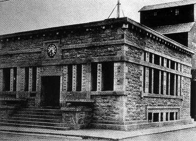
The Stonewall Post Office (now the town library) built with stone from the local quarry.
Source: Archives of Manitoba
With a steady influx of settlers to the area after 1880, Samuel Jackson was able to give more time to his other business and political interests. By 1905, when he had been elected to the Federal House of Commons, several independent quarries had come into operation, associated with names such as Fulbrooke, Higginbotham, Patterson, Bowles and Clarke. In June of 1904 the Stonewall Argus reported on the activities of the Winnipeg Supply Company which had bought out Fulbrooke and Higginbothom. ‘A draw-kiln is being erected which will burn 500 to 600 bushels of lime daily.’ In the same year the veteran quarry operator John Gunn gave his opinion about future prospects for the company’s quarry: ‘It has the distinction of being the only really white lime in the province’ and since ‘white is necessary for plaster, and Stonewall is the only source of supply’ a good future was evident. From his own quarries in 1904 Mr. Gunn had produced 100,000 bushels of lime, 10,000 chords of rubble and given work to 150 men. In the years that followed, the stone industries of Stonewall moved towards even greater consolidation, the key to which was to be found in the advantages of the ‘white’ limestone.
By 1917 the contraction of the Manitoba limestone quarry industries into the hands of a few entrepreneurs was well underway. At Stonewall, business was dominated by two firms: the Winnipeg Supply and Fuel Company and Manitoba Quarries Limited. By that year five large draw kilns had been built, three in today’s park and two in a quarry a short distance to the east. After World War I, Winnipeg Supply entered into a relationship with the Moosehorn Lime Company which was advantageous to both, and kept each company specializing in those areas where it had strength. By 1927, Winnipeg Supply and Fuel controlled all of the local quarries.
Samuel J. Jackson Samuel Jackson was born in Stradbailey, Queen’s County, Ireland in 1848. As a two year old he was brought to the Brampton area west of Toronto by his father. By 1867 the young Jackson had gained commercial experience in Norwich and then departed for Manitoba in 1871 via the St. Paul route. Almost immediately he showed interest in the Grassmere area where he made ‘pencil entries’ for land. In 1872 he worked as a clerk for Mr. John Higgins of Winnipeg but In 1876 he left Higgins to join Cue, Stobart and Co. He was then sent abroad to London to buy import goods for the retail trade. Upon his return he bought in with his old employer, becoming a partner in the firm Higgins, Young and Jackson. Their business was apparently the first to ship grain out the west to eastern Canada. Jackson maintained the partnership until he relocated to Stonewall in 1878. Politics was very much in Jackson’s blood. Between 1877 and 1880 he served as an alderman in the young city of Winnipeg. He then turned to provincial politics and was returned six times to the House between 1883 and 1899 when he was defeated. In that period he served two terms as Speaker of the House. In 1904 he was elected to the House of Commons for the constituency of Selkirk. By the time of his death in 1942 he had become one of Manitoba’s elder statesmen and an institution in the town which he had done so much to found. At the time of his death, Stonewall, with its many finally crafted buildings and its large draw kilns, had become the most concentrated social and industrial expression of the Interlake limestone landscape.
|
Lime had long been recognized by farmers in the British Isles and elsewhere as good substance for the treatment of alkaline soils for purposes of reducing acidity. In 1810 the newly formed British Board of Agriculture, commissioned a series of Country Surveys. In response, Sir John Sinclair produced the massive survey for Dumfriesshire in 1812, a report containing valuable advice on the liming of soils as practiced by Scots who, over the previous forty years, had vastly improved the productivity of lowland agriculture. [5] Many of the nineteenth century immigrants to Canada came bearing knowledge of such useful practices, and the availability of local limestone was therefore an important aspect of land appraisal and selection.
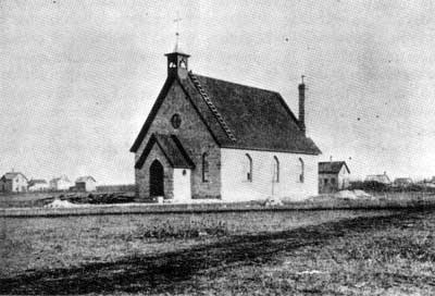
Anglican Church at Stonewall, 1884.
Source: Glenbow Archives
There were many uses for Interlake lime, in addition to its use in agricultural soil treatments for reducing soil acidity. One writer noted in 1927 that the local produce of lime ‘is well adapted to the sulphite pulp process’ as ‘a finishing lime for plaster work’ while ‘for mortar it has a high reputation.’ These various demands were reflected in the local additions to the operations. At the Number Three Quarry east of the park, a large stonecrusher was put in place for the production of primary construction material. The five kilns continued to produce quicklime much of which was shipped to Canada Gypsum and Alabasine Ltd. for hydration in its Winnipeg plant.
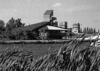
The Stonewall Quarry site today.
Many of the displays in the Visitor Centre provide some insight into the daily life of those who made the quarries function along with the kinds of tasks involved. It was hard and dirty work requiring proper dress to prevent lime burns but the character of the work changed somewhat with improvements in technology and altered product demands. Power drills had come into use by the 1930s along with other labour-saving devices. The great white bluffs of slag from the kilns which are visible in the park testify to the great amount of material quarried and burned in the kilns up to the year 1967.
At Stonewall there are many examples of the stonemason’s art. The home of John Gunn built in 1900 and still stands on the edge of town. The old post office building, now serving as the library, was designed by Francis C. Sullivan, a student of Frank Lloyd Wright, and is an excellent example of the “prairie school” style. One of Manitoba’s finest stone churches, the Anglican Church of the Ascension, dates from 1882, the materials having been donated from the quarry of the Williams brothers.
The great building boom in Winnipeg between 1890 and 1920 provided a steady market for the regional quarry supply towns, including those of Garson and Tyndall. The Manitoba Legislature was constructed from a variety of local limestones. Many other famous buildings in Canada were made from these quarries including Eaton’s College Street Store in Toronto, portions of the Canadian Parliament Buildings, and many of the great railway hotels such as the Banff Springs and Ottawa’s Chateau Laurier. The mottled limestone or “Tyndall Stone” was in particular demand for finishing aspects of these buildings and achieved wide recognition in the building trades. The ‘Gunn” stones from Stonewall were in demand more for foundation work.
In addition to detailing aspects of the geological, social and industrial aspects of quarry enterprise, another guiding idea for the new park was to draw the visitor’s attention to some of the natural and cultural values of the local landscape. Thus, in the Visitor Centre displays deal with the uses made of the escarpment by earlier generations of Aboriginal hunters in their quest for game. The artist and museum display designer, Duane Harty provided a detailed painting on the interrelationships of the flora and fauna, characteristic of the local limestone environment. One early chronicler of Stonewall observed that the pioneer generation encountered a land mostly ‘covered with a growth of scrub willow, pin-cherry, choke-cherry, wild plum, hawthorne, hazelnut, saskatoon, and such trees as maple, poplar, and last but not least, the sturdy oak.’ The park has sought to preserve certain natural areas where such species may thrive, providing cover for birds and smaller animals. Visitors are provided with informative trail guides and outdoor signage useful for plant and wildlife identification. While S. J. Jackson died in 1942, a mannequin of this interesting personage at his desk looks out at visitors in the centre. The surroundings of contemporary Stonewall would not be totally foreign to him today.
1. Cf. Cyril E. Hart, Royal Forest: A History of Dean’s Woods as Producers of Timber. Oxford: Clarendon Press, 1966, 107,114,124; and D. G. O Allan, “The Rising in the West, 1628-1631”, Economic History Review, 5(1952),76-85.
2. Cf. Barry Cooper, Alexander Kennedy Isbister: A Respectable Critic of the Honourable Company. Ottawa: Carlton University Press, 198S, 39-46.
3. Worth Bailey, “Lime Preparation at Jamestown in the Seventeenth Century”, William and Mary Quarterly, 18(1), 1938, 1-16.
4. Robert Plot, The Natural History of Oxfordshire, Oxford: 1676 and The Natural History of Staffordshire, Oxford, 1686; Charles Spackman, Some Writers on Lime and Cement from Cato to the Present Time. Cambridge: 1929; Charles Lindsay, Lime Preparation in Eighteenth Century Louisbourg. Canadian Historic Sites: Occasional Papers in Archaeology and History, no. 12. Ottawa: Department of Indian Affairs and Northern Development, 1975.
5. W. G. M. Dobie, Old Time Farming in Dumfriesshire. Dumfries: Robert Dinwiddie, 1949, 1-3.
Page revised: 26 September 2012

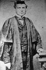 Alexander Kennedy Ibister’s place in the history of Canada has not been forgotten, but the range of his contributions was quite astonishing. Geology is not normally associated with his name, owing to the important role he played, from distant England, in gaining acceptance for the right of his fellow Métis and settlers of all backgrounds during the years of transition from the Husdon’s Bay Company rule to that of the new Dominion. This talented son of Rupert’s Land was born in 1822 at Cumberland House to the Orkneyman Thomas Isbister and his wife Mary Kennedy. Mary was the daughter of the fur trader Alexander Kennedy and his Native wife Agatha. Young Alex was educated in the Orkney Islands and at Red River. It had been expected that Alexander would follow in the family footsteps of the fur trade life, which he did indeed do for some time, having apprenticed at age sixteen and sent into the MacKenzie District. After six years in the high country, Isbister decided that his life should follow a different course. Against the counsel of his superiors he left for Scotland and enrolled at the University of Aberdeen. His past experiences informed his first literary contributions. In 1845 his published in the Journal of the Royal Geographical Society an article entitled’ ‘Some Account of the Peel River, N. America.’ After that his achievements were many as a teacher, critic of the Hudson’s Bay Company, advocate for the rights of the original residents of the northwest, and a call to the British Bar. One of his less known but important achievements was in geological mapping based on his travels as a young man. In 1855 he published On the Geology of the Hudson’s Bay Territories and of Portions of the Arctic and North-Western Regions of America which appeared in the Quarterly Journal of the Geological Society of London.