View the route taken by the 1870 Wolseley expedition from Lake Superior to the Red River Settlement using Google Earth.
INSTRUCTIONS
|
Once the Dawson’s Road 1870 Google Earth file has been downloaded you can begin exploring the information associated with the file by clicking on the various folders found under the Dawson’s Road file title. The following is a list of the contents of each folder.
Legend - Just like a traditional map the Legend explains the meaning of the symbols. However, unlike a paper map these icons can be clicked on to display more information. For the 1870 Dawson’s Road map the legend icons represent depots, bridges, shanties and a listing of additional resources that went into construction the visualization.
Map Overlays - These are various printed maps from 1870 that were used to reconstruct the route of the road and include a section of the main 1870 map by S. J. Dawson along with various maps by Captain Huyshe’s that show building footprints of the river depots and encampments. It is important to note that theses overlays can not be matched exactly on the modern landscape and as such are for illustration only.
Paintings - This folder contains the images of paintings by William Armstrong and others that are available online. The images have been added to the pop-up balloons and set at the approximate angle of view at which they were painted in order to see the landscape today along side the paintings from 1870.
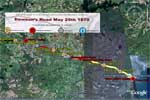
Dawson’s Road - This folder consists of five road segments that are broken down according to Captain Huyshe’s description of the road as it was when Colonel Wolseley arrived at Prince Arthurs Landing May 25th 1870.
Map Elements - This folder consists place marks that highlighting depots, bridges, mile markers and other important features found on the 1870 map and in various first hand accounts. Where possible the accounts have been added to place marks.
GIS Data (Rivers) - This Folder highlights the important rivers that had to be crossed by Dawson’s road and navigated when moving supplies to the depots. Video Serves a depository for video clips that highlight some of the natural features of the area, for example Kakabeka Falls.
3D Elements - The folder will eventually house any 3D models that might be added to the file, included reconstructed depots showing buildings and other aspects of the encampment.
Page revised: 1 May 2025